

The last avalanche forecast for the 2023-2024 season will post on April 21st. Thank you to all who contributed to the avalanche center this season through observations, volunteer time, and/or financial contributions.
In partnership with: 
The last avalanche forecast for the 2023-2024 season will post on April 21st. Thank you to all who contributed to the avalanche center this season through observations, volunteer time, and/or financial contributions.
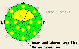
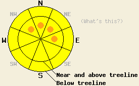
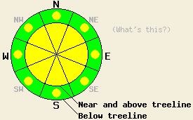
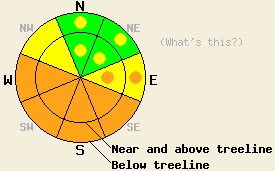
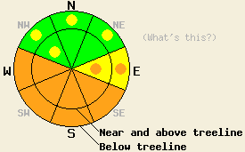
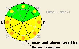
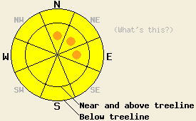
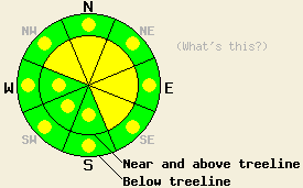
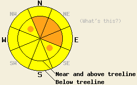
Use this page to view archived advisories. The table below shows the overall danger rating and the bottom line for the 20 most recent advisories. Click on the time and date link above each danger rating icon to view the full advisory for that day. Use the date chooser or the pager at the bottom to scroll through the older advisories.
|
Date the forecast was published: |
Bottom Line | |
|---|---|---|
|
Click here to see the full forecast for 2010-02-23 |
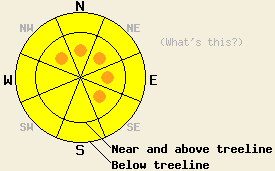
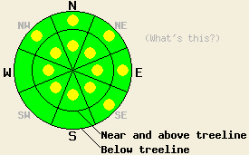
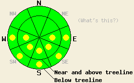
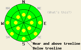
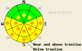
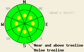
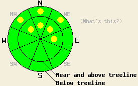
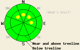
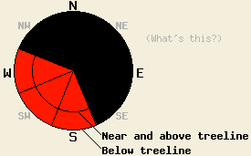
February 23, 2010 at 7:48 Near and above treeline, pockets of MODERATE danger linger in recently wind loaded areas on NW-N-NE aspects, 35 degrees and steeper. Below treeline, avalanche danger is LOW in wind protected areas. Increasing avalanche danger is expected overnight into Wednesday. |
 |
|
Click here to see the full forecast for 2010-02-24 |
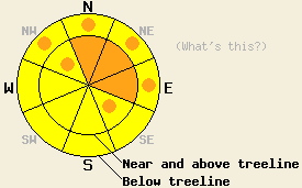
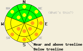
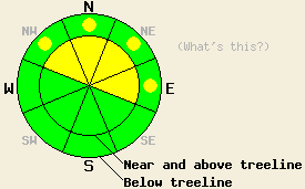
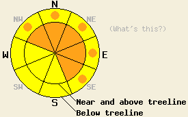
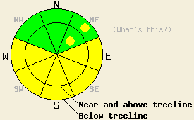
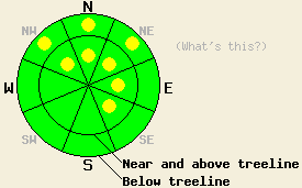
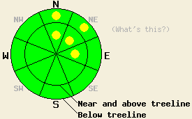
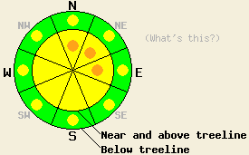
February 24, 2010 at 8:01 Near and above treeline on slopes 35 degrees and steeper, pockets of CONSIDERABLE danger exist on wind-loaded N-NE-E aspects and on cross-loaded NW and SE aspects. MODERATE avalanche danger exists on all other slopes steeper than 35 degrees. |
 |
|
Click here to see the full forecast for 2010-02-25 |
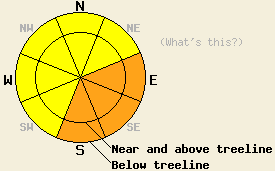
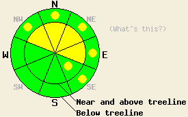
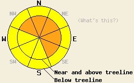
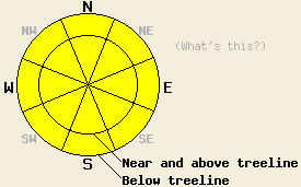
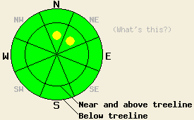
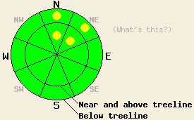
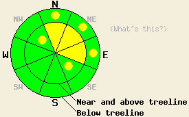
February 25, 2010 at 8:01 MODERATE avalanche danger exists on all slopes steeper than 35 degrees. Careful snowpack evaluation and terrain choices are a must for today due to variability in the snowpack. |
 |
|
Click here to see the full forecast for 2010-02-26 |
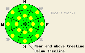
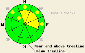
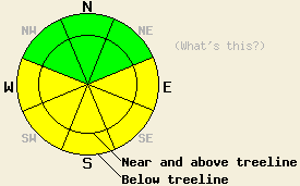
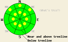
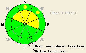
February 26, 2010 at 8:01 MODERATE avalanche danger exists on all slopes steeper than 35 degrees today. The avalanche danger will increase to CONSIDERABLE tonight on wind-loaded NW-N-NE-E-SE slopes steeper than 35 degrees both above and below treeline as more snow and wind impact the forecast area. |
 |
|
Click here to see the full forecast for 2010-02-27 |
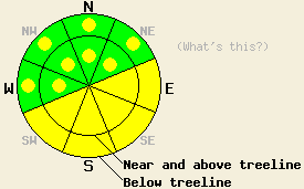
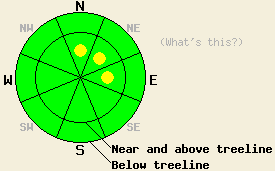
February 27, 2010 at 7:58 Near and above treeline, avalanche danger is MODERATE with pockets of CONSIDERABLE danger on N-NE-E aspects 35 degrees and steeper. Below treeline, avalanche danger is MODERATE on all slopes 35 degrees and steeper. Large destructive avalanches are possible today. |
 |
|
Click here to see the full forecast for 2010-02-28 |
February 28, 2010 at 7:52 Avalanche danger is LOW with pockets of MODERATE danger at all elevations, on all aspects, on slopes 35 degrees and steeper. This is due to lingering new and old snow instabilities on mid and high elevation NW-N-NE aspects and warming instability involving the new snow at all elevations on E-SE-S-SW-W aspects and mid to lower elevation NW-N-NE aspects. |
 |
|
Click here to see the full forecast for 2010-03-01 |
March 1, 2010 at 8:01 Near and above treeline, avalanche danger is MODERATE on NW-N-NE aspects, 35 degrees and steeper due to deep slab instability. Avalanche danger is LOW with pockets of MODERATE danger due to warming instability involving the recent new snow at all elevations on E-SE-S-SW-W aspects and mid to lower elevation NW-N-NE aspects, on slopes 35 degrees and steeper. Large destructive avalanche remain possible. |
 |
|
Click here to see the full forecast for 2010-03-02 |
March 2, 2010 at 8:02 Near and above treeline, avalanche danger is MODERATE on NW-N-NE-E aspects with pockets of MODERATE danger on SE aspects, 35 degrees and steeper due to deep slab instability and new wind loading. Below treeline, the avalanche danger is LOW with pockets of MODERATE danger on NW-N-NE-E-SE aspects on slopes 35 degrees and steeper. Large destructive avalanches remain possible. |
 |
|
Click here to see the full forecast for 2010-03-03 |
March 3, 2010 at 8:00 Near and above treeline during the day today on slopes 35 degrees and steeper, the avalanche danger will rise to CONSIDERABLE on N-NE-E aspects with pockets of CONSIDERABLE on the NW and SE aspects. Below treeline pockets of CONSIDERABLE danger will also develop on the NW-N-NE-E aspects on slopes steeper than 35 degrees. In all other areas the avalanche danger is MODERATE. Large destructive avalanches remain possible. |
 |
|
Click here to see the full forecast for 2010-03-04 |
March 4, 2010 at 8:00 Near and above treeline on slopes 35 degrees and steeper, the avalanche danger is MODERATE on all aspects. Below treeline pockets of MODERATE danger exist on all aspects on slopes steeper than 35 degrees. Large destructive avalanches remain possible. |
 |
|
Click here to see the full forecast for 2010-03-05 |
March 5, 2010 at 7:40 Avalanche danger is LOW for all elevations and aspects. Human triggered avalanches are unlikely but not impossible on NW-N-NE aspects near and above treeline and below 8,000' on sun exposed E-SE-S-SW aspects. |
 |
|
Click here to see the full forecast for 2010-03-06 |
March 6, 2010 at 7:52 Avalanche danger is LOW for all elevations and aspects. Very isolated areas of instability may exist. Snowfall amounts greater than forecast expectations could create isolated areas of locally higher avalanche danger today. |
 |
|
Click here to see the full forecast for 2010-03-07 |
March 7, 2010 at 8:03 Avalanche danger is LOW with pockets of MODERATE danger due to wet snow instability developing below 8,000' on E-SE-S-SW-W aspects 35 degrees and steeper in response to daytime warming. Very isolated areas of deep slab instability linger above treeline on NW-N-NE aspects in rocky terrain, 40 degrees and steeper. |
 |
|
Click here to see the full forecast for 2010-03-08 |
March 8, 2010 at 8:02 Near and above treeline, pockets of MODERATE avalanche danger will develop on NW-N-NE-E facing slopes steeper than 35 degrees as more snow and wind impact the forecast area this afternoon. Very isolated areas of deep slab instability linger above treeline on NW-N-NE aspects in rocky terrain, 40 degrees and steeper. Below treeline the avalanche danger should remain LOW. If more snow falls than the forecast calls for, the avalanche danger will increase and become more widespread. |
 |
|
Click here to see the full forecast for 2010-03-09 |
March 9, 2010 at 7:57 Pockets of MODERATE avalanche danger exist on NW-N-NE-E-SE facing slopes steeper than 35 degrees on wind-loaded slopes at all elevations. Very isolated areas of deep slab instability linger near and above treeline on NW-N-NE aspects in rocky terrain, 40 degrees and steeper. |
 |
|
Click here to see the full forecast for 2010-03-10 |
March 10, 2010 at 8:00 Near and above treeline, pockets of MODERATE avalanche danger exist on all aspects steeper than 35 degrees due to shifting winds wind loading a variety of slopes. Very isolated areas of deep slab instability linger near and above treeline on NW-N-NE aspects in rocky terrain, 40 degrees and steeper. Below treeline pockets of MODERATE danger remain on wind-loaded NW-N-NE-E-SE aspects steeper than 35 degrees. |
 |
|
Click here to see the full forecast for 2010-03-11 |
March 11, 2010 at 7:21 Areas of MODERATE avalanche danger will exist today at all elevations on sun exposed E-SE-S-SW-W aspects, 35 degrees and steeper. For all other areas, avalanche danger is LOW. |
 |
|
Click here to see the full forecast for 2010-03-12 |
March 12, 2010 at 7:44 Near and above treeline, avalanche danger will rise to MODERATE this afternoon and on to CONSIDERABLE this evening on NW-N-NE-E-SE aspects, 35 degrees and steeper. Below treeline, avalanche danger is LOW with areas of MODERATE avalanche danger forming during the afternoon and evening hours on all aspects, 35 degrees and steeper. Natural slab avalanche activity is expected beginning late this afternoon and continuing overnight. If the top end of forecast snowfall amounts are reached, a short period of HIGH avalanche danger is possible after sunset. |
 |
|
Click here to see the full forecast for 2010-03-13 |
March 13, 2010 at 7:43 Avalanche danger is CONSIDERABLE below 8,500' on E-SE-S aspects 35 degrees and steeper due to warming instability. Avalanche danger is MODERATE both above and below treeline on all other aspects 35 degrees and steeper. |
 |
|
Click here to see the full forecast for 2010-03-14 |
March 14, 2010 at 7:00 Pockets of CONSIDERABLE avalanche danger will form on E-SE-S-SW aspects 35 degrees and steeper due to warming instability today. Pockets of MODERATE avalanche danger will exist both above and below treeline on all other aspects 35 degrees and steeper. |
 |
|
Click here to see the full forecast for 2010-03-15 |
March 15, 2010 at 7:00 The avalanche danger will rise to MODERATE on the sun-exposed E-SE-S-SW slopes steeper than 35 degrees due to daytime warming today. Pockets of MODERATE danger linger on the most heavily wind loaded W-NW-N-NE aspects steeper than 35 degrees. |
 |
|
Click here to see the full forecast for 2010-03-16 |
March 16, 2010 at 7:00 On slopes steeper than 35 degrees, the avalanche danger will rise to MODERATE on the sun-exposed E-SE-S-SW-W aspects due to daytime warming today. On the NW-N-NE aspects the avalanche danger will remain LOW. |
 |
|
Click here to see the full forecast for 2010-03-17 |
March 17, 2010 at 6:53 Early this morning, avalanche danger is LOW for all elevations and aspects. Pockets of MODERATE avalanche danger will form at all elevations on E-SE-S-SW-W aspects 37 degrees and steeper in response to daytime warming. |
 |
|
Click here to see the full forecast for 2010-03-18 |
March 18, 2010 at 6:35 Early this morning, avalanche danger is LOW for all elevations and aspects. Isolated pockets of MODERATE avalanche danger will form mainly below 8,500' on E-SE-S-SW-W aspects 37 degrees and steeper in response to daytime warming. |
 |
|
Click here to see the full forecast for 2010-03-19 |
March 19, 2010 at 6:40 Early this morning, avalanche danger is LOW for all elevations and aspects. Pockets of MODERATE avalanche danger will develop at all elevations on E-SE-S-SW-W aspects 37 degrees and steeper in response to daytime warming. |
 |
|
Click here to see the full forecast for 2010-03-20 |
March 20, 2010 at 7:01 This morning, LOW avalanche danger exists for all elevations and aspects. Pockets of MODERATE avalanche danger will quickly develop at all elevations on E-SE-S-SW-W aspects 37 degrees and steeper in response to daytime warming. |
 |
|
Click here to see the full forecast for 2010-03-21 |
March 21, 2010 at 7:00 LOW avalanche danger exists for all elevations and aspects. Some isolated pockets of MODERATE avalanche danger may develop on sun-exposed E-SE-S-SW-W aspects 37 degrees and steeper below 9000' due to daytime warming if the forecast area receives more sun than forecasted or the temperatures climb higher than forecasted. |
 |
|
Click here to see the full forecast for 2010-03-22 |
March 22, 2010 at 6:50 This morning, LOW avalanche danger exists for all elevations and aspects. Some pockets of MODERATE avalanche danger may develop today on sun-exposed E-SE-S-SW-W aspects 37 degrees and steeper below 9000' due to daytime warming. |
 |
|
Click here to see the full forecast for 2010-03-23 |
March 23, 2010 at 6:58 Early this morning, avalanche danger is LOW for all elevations and aspects. Some pockets of MODERATE avalanche danger will develop today on sun-exposed E-SE-S-SW-W aspects 37 degrees and steeper in response to daytime warming. |
 |
|
Click here to see the full forecast for 2010-03-24 |
March 24, 2010 at 7:00 Early this morning, avalanche danger is LOW for all elevations and aspects. Pockets of MODERATE avalanche danger will develop today on sun-exposed E-SE-S-SW-W aspects 37 degrees and steeper in response to daytime warming. |
 |
|
Click here to see the full forecast for 2010-03-25 |
March 25, 2010 at 6:54 North of Lake Tahoe, avalanche danger is MODERATE in near and above treeline terrain on NW-N-NE-E aspects, 35 degrees and steeper. Below treeline avalanche danger is LOW with pockets of MODERATE danger in wind affected areas on NW-N-NE-E aspects 35 degrees and steeper. From Lake Tahoe southward, avalanche danger is LOW with pockets of MODERATE danger near and above treeline in wind loaded areas on NW-N-NE-E aspects 35 degrees and steeper. Below treeline avalanche danger is LOW. |
 |
|
Click here to see the full forecast for 2010-03-26 |
March 26, 2010 at 7:00 MODERATE avalanche danger exists in near and above treeline terrain on NW-N-NE-E aspects, 35 degrees and steeper with pockets of MODERATE danger on SE aspects. Below treeline avalanche danger is LOW with pockets of MODERATE danger in wind affected areas on NW-N-NE-E-SE aspects 35 degrees and steeper. |
 |
|
Click here to see the full forecast for 2010-03-27 |
March 27, 2010 at 7:02 Pockets of MODERATE avalanche danger exist on all aspects on slopes 35 degrees and steeper at all elevations. Shifting winds causing wind loading on various slopes and increased daytime warming will comprise the main avalanche concerns today. |
 |
|
Click here to see the full forecast for 2010-03-28 |
March 28, 2010 at 6:54 Pockets of MODERATE avalanche danger will form on the sun-exposed E-SE-S-SW-W aspects on slopes 35 degrees and steeper due to daytime warming today. Near and above treeline a few isolated pockets of MODERATE danger may still exist on the most wind-loaded NW-N-NE aspects steeper than 37 degrees north of Lake Tahoe. |
 |
|
Click here to see the full forecast for 2010-03-29 |
March 29, 2010 at 7:03 Avalanche danger is LOW for all elevations and aspects. Very isolated areas of instability may exist. Normal caution is advised. A significant increase in avalanche danger is expected to occur on Tuesday. |
 |
|
Click here to see the full forecast for 2010-03-30 |
March 30, 2010 at 6:57 Near and above treeline, avalanche danger will rise to CONSIDERABLE as the day progresses on NW-N-NE-E-SE aspects, 35 degrees and steeper. Below treeline, avalanche danger will rise to MODERATE with pockets of CONSIDERABLE danger in open wind affected areas on NW-N-NE-E-SE aspects, 35 degrees and steeper. |
 |
|
Click here to see the full forecast for 2010-03-31 |
March 31, 2010 at 6:57 Along the Sierra Crest north of Hwy 50, avalanche danger is CONSIDERABLE near and above treeline on NW-N-NE-E-SE aspects 35 degrees and steeper. For all other areas, avalanche danger is MODERATE on all aspects on slopes 35 degrees and steeper. Large destructive avalanches are possible. |
 |
|
Click here to see the full forecast for 2010-04-01 |
April 1, 2010 at 7:00 Near and above treeline MODERATE avalanche danger exists on the NW-N-NE-E aspects 35 degrees and steeper. Below treeline pockets of MODERATE danger exist on the NW-N-NE-E aspects on slopes steeper than 35 degrees. |
 |
|
Click here to see the full forecast for 2010-04-02 |
April 2, 2010 at 6:59 Near and above treeline MODERATE avalanche danger exists on the NW-N-NE-E aspects 35 degrees and steeper. Below treeline LOW avalanche danger exists. As another storm impacts the forecast area this afternoon and tonight, the avalanche danger will increase and could reach CONSIDERABLE on wind-loaded slopes near and above treeline during the night. |
 |
|
Click here to see the full forecast for 2010-04-03 |
April 3, 2010 at 7:00 Near and above treeline pockets of CONSIDERABLE avalanche danger exist on the wind-loaded, NW-N-NE-E aspects 35 degrees and steeper with MODERATE avalanche danger on the other aspects. Below treeline pockets of MODERATE avalanche danger exist on all aspects on slopes steeper than 35 degrees. |
 |
|
Click here to see the full forecast for 2010-04-04 |
April 4, 2010 at 6:50 Near and above treeline, avalanche danger is LOW with pockets of MODERATE danger on NW-N-NE aspects, 37 degrees and steeper. Below treeline, avalanche danger is LOW with pockets of MODERATE danger in open wind affected areas on NW-N-NE aspects, 37 degrees and steeper. Destructive avalanches are possible today in very isolated areas. A significant and widespread increase in avalanche danger is expected to occur during the evening and overnight hours. |
 |
|
Click here to see the full forecast for 2010-04-05 |
April 5, 2010 at 6:45 Near and above treeline, avalanche danger is CONSIDERABLE on NW-N-NE-E-SE aspects, 35 degrees and steeper. Below treeline, avalanche danger is MODERATE in open areas 35 degrees and steeper. Large human triggered avalanches should be expected in steep wind loaded terrain. |
 |
|
Click here to see the full forecast for 2010-04-06 |
April 6, 2010 at 6:42 Avalanche danger is CONSIDERABLE at all elevations on E-SE-S-SW-W aspects 35 degrees and steeper due to warming instability. Pockets of MODERATE danger linger on NW-N-NE aspects 37 degrees and steeper both above and below treeline due to recent storm snow instability. |
 |
|
Click here to see the full forecast for 2010-04-07 |
April 7, 2010 at 7:00 Pockets of CONSIDERABLE avalanche danger will form at all elevations on E-SE-S-SW-W aspects 35 degrees and steeper due to daytime warming. Small isolated pockets of MODERATE danger linger on NW-N-NE aspects 37 degrees and steeper near and above treeline in complex wind-loaded terrain. |
 |
|
Click here to see the full forecast for 2010-04-08 |
April 8, 2010 at 6:54 This morning the avalanche danger is LOW. The avalanche danger will quickly increase to MODERATE at all elevations on E-SE-S-SW-W aspects 35 degrees and steeper due to daytime warming. |
 |
|
Click here to see the full forecast for 2010-04-09 |
April 9, 2010 at 6:57 This morning the avalanche danger is LOW. The avalanche danger will increase to MODERATE at all elevations on E-SE-S-SW-W aspects 35 degrees and steeper due to daytime warming. |
 |
|
Click here to see the full forecast for 2010-04-10 |
April 10, 2010 at 6:47 Avalanche danger is LOW with pockets of MODERATE danger in open areas at all elevations on E-SE-S-SW-W aspects 37 degrees and steeper. |
 |
|
Click here to see the full forecast for 2010-04-11 |
April 11, 2010 at 6:56 This morning, avalanche danger is LOW for all elevations and aspects. After the onset of snowfall, pockets of MODERATE danger will form near and above treeline on NW-N-NE-E aspects 35 degrees and steeper. Avalanche danger will likely to increase to CONSIDERABLE during the evening and overnight hours with natural avalanche activity possible. |
 |
|
Click here to see the full forecast for 2010-04-12 |
April 12, 2010 at 6:40 South of Hwy 50 along the Sierra Crest, avalanche danger near and above treeline is CONSIDERABLE on NW-N-NE-E-SE aspects 35 degrees and steeper. Below treeline, avalanche danger is MODERATE on all aspects, 35 degrees and steeper. North of Hwy 50 along the Sierra Crest and for the Carson Range, avalanche danger near and above treeline is MODERATE on NW-N-NE-E-SE aspects 35 degrees and steeper. Below treeline, avalanche danger is LOW with pockets of MODERATE danger on all aspects, 35 degrees and steeper. |
 |
|
Click here to see the full forecast for 2010-04-13 |
April 13, 2010 at 7:00 MODERATE avalanche danger exists on all aspects and at all elevations on slopes 35 degrees and steeper due to lingering wind slabs, poor bonding between the new snow and the crusts below it, and the formation of warming instabilities during the day today. If slopes receive more sunshine than forecasted the avalanche danger on sun-exposed southerly slopes may increase. |
 |
|
Click here to see the full forecast for 2010-04-14 |
April 14, 2010 at 7:00 MODERATE avalanche danger will form on E-SE-S-SW-W aspects at all elevations on slopes 35 degrees and steeper due to daytime warming. Isolated pockets of MODERATE avalanche danger may also form on some NE aspects that warm up today. If slopes receive more sunshine than forecasted the avalanche danger may increase. |
 |
|
Click here to see the full forecast for 2010-04-15 |
April 15, 2010 at 6:49 MODERATE avalanche danger will form on E-SE-S-SW-W aspects at all elevations on slopes 35 degrees and steeper due to daytime warming. |
 |
|
Click here to see the full forecast for 2010-04-16 |
April 16, 2010 at 6:43 Avalanche danger is MODERATE on E-SE-S-SW-W aspects at all elevations on slopes 35 degrees and steeper due to warming instability and poor overnight refreeze. Very, very isolated pockets of instability linger on northerly aspects. Normal caution is advised. |
 |
|
Click here to see the full forecast for 2010-04-17 |
April 17, 2010 at 6:45 Early this morning, avalanche danger is LOW for all elevations and aspects. Pockets of MODERATE danger will form at all elevations on E-SE-S-SW-W aspects in response to daytime warming. Very isolated areas of instability may exist on northerly aspects. Normal caution is advised. |
 |
|
Click here to see the full forecast for 2010-04-18 |
April 18, 2010 at 6:49 Very early this morning, avalanche danger is LOW for all elevations and aspects. Pockets of MODERATE danger will develop quickly today at all elevations on E-SE-S-SW-W aspects 35 degrees and steeper in response to daytime warming. |
 |
|
Click here to see the full forecast for 2010-04-19 |
April 19, 2010 at 6:15 Early this morning, the avalanche danger is LOW for all elevations and aspects. As the sun hits the snow and the day warms up, pockets of MODERATE danger will quickly form on the E-SE-S-SW-W aspects 35 degrees and steeper at all elevations. |
 |
|
Click here to see the full forecast for 2010-04-20 |
April 20, 2010 at 6:56 This morning, avalanche danger is MODERATE below 9,000' on all aspects on slopes 37 degrees and steeper due to wet snow instability. After the onset of precipitation, concerns will gradually shift to storm snow instability with avalanche danger remaining at MODERATE above and below treeline on all aspects on slopes 35 degrees and steeper. Pockets of CONSIDERABLE danger may form in wind loaded areas on NW-N-NE-E aspects 37 degrees and steeper this afternoon or tonight if the upper end of forecast snowfall amounts are reached. |
 |
|
Click here to see the full forecast for 2010-04-21 |
April 21, 2010 at 6:46 Near and above treeline, avalanche danger is MODERATE in recently wind loaded areas on all aspects on slopes 35 degrees and steeper. Below treeline, pockets of MODERATE danger exist on all aspects in open areas on slopes 35 degrees and steeper. |
 |
|
Click here to see the full forecast for 2010-04-22 |
April 22, 2010 at 6:47 Near and above treeline, avalanche danger is MODERATE in recently wind loaded areas on all aspects on slopes 35 degrees and steeper. Below treeline, pockets of MODERATE danger exist on all aspects in open areas on slopes 35 degrees and steeper. |
 |
|
Click here to see the full forecast for 2010-04-23 |
April 23, 2010 at 7:00 The avalanche danger will rise to CONSIDERABLE today on the sun-exposed SE-S-SW-W aspects steeper than 35 degrees due to rapid daytime warming. Some pockets of CONSIDERABLE danger may also form on E aspects. On the NW-N-NE aspects areas of MODERATE avalanche danger still remain on wind-loaded slopes. |
 |
|
Click here to see the full forecast for 2010-04-24 |
April 24, 2010 at 7:00 The avalanche danger will rise to CONSIDERABLE again today on the sun-exposed SE-S-SW-W aspects steeper than 35 degrees due to daytime warming. Pockets of CONSIDERABLE danger may also form on E aspects. On the cross-loaded NW aspects near and above treeline and the NW-N-NE aspects below treeline pockets of MODERATE avalanche danger exist. |
 |
|
Click here to see the full forecast for 2010-04-25 |
April 25, 2010 at 7:00 Near and above treeline, the avalanche danger will rise to MODERATE on the sun-exposed E-SE-S-SW-W aspects steeper than 35 degrees due to daytime warming. Below treeline pockets of CONSIDERABLE danger will form on the E-SE-S-SW-W aspects. Pockets of MODERATE avalanche danger may also form on NW-N-NE aspects below treeline. |
 |
|
Click here to see the full forecast for 2010-04-26 |
April 26, 2010 at 7:39 We have stopped issuing daily avalanche advisories until the fall of 2010. The avalanche danger can and will change quickly during this spring. Continue to monitor changing conditions and use caution when traveling in the backcountry. For general spring avalanche information read the full spring avalanche statement. |
|
|
Click here to see the full forecast for 2010-10-04 |
October 4, 2010 at 17:50 Fall Avalanche Statement Daily avalanche advisories will resume in mid November or later as conditions dictate. Occasional intermittent early season updates to this page may occur earlier if conditions warrant and resources are available. |
|
|
Click here to see the full forecast for 2010-11-19 |
November 19, 2010 at 7:44 For most of today, avalanche danger is LOW for all elevations and aspects. Isolated areas of instability may form this evening after the onset of snowfall sometime this afternoon. A significant increase in avalanche danger is expected overnight into Saturday. |
 |
|
Click here to see the full forecast for 2010-11-20 |
November 20, 2010 at 7:43 Near and above treeline, avalanche danger is MODERATE with pockets of CONSIDERABLE danger on N-NE-E aspects, 35 degrees and steeper. Below treeline, avalanche danger is MODERATE in open areas, 35 degrees and steeper. Rocks, down trees, and stumps will present a significant hazard to backcountry travelers today due to the overall shallow snow cover. An increase in avalanche danger is expected to occur tonight in response to high intensity snowfall. |
 |
|
Click here to see the full forecast for 2010-11-21 |
November 21, 2010 at 7:55 Near and above treeline, avalanche danger is CONSIDERABLE danger on NW-N-NE-E-SE aspects, 35 degrees and steeper. Below treeline, avalanche danger is MODERATE in open wind affected areas, 35 degrees and steeper. |
 |
|
Click here to see the full forecast for 2010-11-22 |
November 22, 2010 at 7:46 Near and above treeline, avalanche danger is MODERATE on NW-N-NE-E-SE aspects 35 degrees and steeper. For all other areas, avalanche danger is LOW with isolated pockets of MODERATE danger in open wind loaded areas on all aspects, 35 degrees and steeper. An increase in avalanche danger in expected to occur during the overnight hours into Tuesday. |
 |
|
Click here to see the full forecast for 2010-11-23 |
November 23, 2010 at 7:58 Near and above treeline on slopes steeper than 35 degrees, CONSIDERABLE avalanche danger exists on N-NE-E aspects with pockets of CONSIDERABLE danger on the NW and SE aspects. On all other aspects above treeline and on all aspects below treeline the avalanche danger is MODERATE. The most likely time for natural avalanches and easily human-triggered avalanches will be during the period of intense snowfall and strong winds forecasted to occur through midday today. |
 |
|
Click here to see the full forecast for 2010-11-23 |
November 23, 2010 at 7:59 Near and above treeline on slopes steeper than 35 degrees, CONSIDERABLE avalanche danger exists on N-NE-E aspects with pockets of CONSIDERABLE danger on the NW and SE aspects. On all other aspects above treeline and on all aspects below treeline, the avalanche danger is MODERATE. The most likely time for natural avalanches and easily human-triggered avalanches will be during the period of intense snowfall and strong winds forecasted to occur through midday today. |
 |
|
Click here to see the full forecast for 2010-11-24 |
November 24, 2010 at 7:30 Near and above treeline on slopes steeper than 35 degrees, MODERATE avalanche danger exists on all aspects. Below treeline pockets of MODERATE avalanche danger exist on open slopes steeper than 35 degrees. Human-triggered avalanches are possible today. |
 |
|
Click here to see the full forecast for 2010-11-25 |
November 25, 2010 at 6:36 Isolated pockets of MODERATE avalanche danger remain on the most heavily wind-loaded N-NE-E-SE aspects and on newly wind-loaded NW-W-SW-S-SE aspects near and above treeline on slopes steeper than 35 degrees. Below treeline the avalanche danger is LOW. |
 |
|
Click here to see the full forecast for 2010-11-26 |
November 26, 2010 at 7:57 Near and above treeline, very isolated pockets of MODERATE avalanche danger may exist on N-NE aspects, 37 degrees and steeper. For all other areas, avalanche danger is LOW. |
 |
|
Click here to see the full forecast for 2010-11-27 |
November 27, 2010 at 7:57 As the day progresses, avalanche danger near and above treeline will increase to MODERATE with pockets of CONSIDERABLE danger on N-NE-E aspects, 35 degrees and steeper. Below treeline, avalanche danger is LOW with pockets of MODERATE danger forming on all aspects in open areas, 35 degrees and steeper. |
 |
|
Click here to see the full forecast for 2010-11-28 |
November 28, 2010 at 7:48 Near and above treeline, avalanche danger is LOW with pockets of MODERATE danger on NW-N-NE-E-SE aspects 35 degrees and steeper. Below treeline, avalanche danger is LOW with pockets of MODERATE danger on NW-N-NE aspects, 35 degrees and steeper. |
 |
|
Click here to see the full forecast for 2010-11-29 |
November 29, 2010 at 8:02 Isolated pockets of MODERATE avalanche danger exist on all aspects 35 degrees and steeper near and above treeline. Below treeline isolated pockets of MODERATE avalanche danger exist on NW-N-NE aspects on slopes 35 degrees and steeper. |
 |
|
Click here to see the full forecast for 2010-11-30 |
November 30, 2010 at 7:30 Isolated pockets of MODERATE avalanche danger exist on NW-N-NE-E aspects 35 degrees and steeper near and above treeline. Below treeline very isolated pockets of MODERATE avalanche danger exist on NW-N-NE aspects on slopes 35 degrees and steeper where a persistent weak layer exists near the base of the snowpack. |
 |
|
Click here to see the full forecast for 2010-12-01 |
December 1, 2010 at 7:49 Isolated pockets of MODERATE avalanche danger exist on N-NE-E aspects 37 degrees and steeper near and above treeline. Below treeline very isolated pockets of MODERATE avalanche danger exist on N-NE aspects on slopes 35 degrees and steeper where a persistent weak layer exists near the base of the snowpack. |
 |
|
Click here to see the full forecast for 2010-12-02 |
December 2, 2010 at 7:58 For nearly all areas, avalanche danger is LOW for all elevations and aspects. Very isolated pockets of MODERATE danger exist near and below treeline on N-NE aspects on slopes 35 degrees and steeper where a persistent weak layer exists near the base of the snowpack. Additional pockets of MODERATE danger may form later today if rain falls on the remaining areas of cold unconsolidated snow on N-NE aspects. |
 |
|
Click here to see the full forecast for 2010-12-03 |
December 3, 2010 at 7:49 For areas north of Hwy 88, avalanche danger near and above treeline is MODERATE on NW-N-NE-E aspects, 35 degrees and steeper. Below treeline, avalanche danger is LOW with pockets of MODERATE danger on N-NE aspects 35 degrees and steeper. South of Hwy 88, avalanche danger is LOW for all elevations and aspects. |
 |
|
Click here to see the full forecast for 2010-12-04 |
December 4, 2010 at 7:50 North of Hwy 88, avalanche danger near and above treeline is LOW with pockets of MODERATE danger lingering on recently wind loaded NW-N-NE-E aspects 35 degrees and steeper. Below treeline and all areas south of Hwy 88, avalanche danger is LOW. Please keep in mind that LOW danger means human trigger avalanches are unlikely, which is different than impossible, especially in highly complex or extreme terrain. |
 |
|
Click here to see the full forecast for 2010-12-06 |
December 6, 2010 at 7:57 Near and above treeline pockets of CONSIDERABLE avalanche danger exist on N-NE-E aspects 35 degrees and steeper with MODERATE danger on other aspects. Below treeline pockets of MODERATE danger exist on open slopes steeper than 35 degrees. |
 |
|
Click here to see the full forecast for 2010-12-07 |
December 7, 2010 at 7:55 Near and above treeline MODERATE avalanche danger exists on N-NE-E aspects 35 degrees and steeper with pockets of MODERATE danger on NW and SE aspects. Below treeline the avalanche danger is mostly LOW with pockets of MODERATE danger on wind-loaded N-NE-E slopes steeper than 35 degrees. |
 |
|
Click here to see the full forecast for 2010-12-08 |
December 8, 2010 at 7:59 Near and above treeline, avalanche danger is LOW with the possible formation of isolated pockets of MODERATE danger above 7,500' after the onset of snowfall on N-NE-E aspects 37 degrees and steeper. For all other areas, avalanche danger is LOW. |
 |
|
Click here to see the full forecast for 2010-12-09 |
December 9, 2010 at 7:55 Near and above treeline, avalanche danger is LOW with pockets of MODERATE danger on NW-N-NE-E-SE aspects, 37 degrees and steeper. Below treeline, avalanche danger is LOW with pockets of MODERATE danger in open areas 37 degrees and steeper. |
 |
|
Click here to see the full forecast for 2010-12-10 |
December 10, 2010 at 7:53 Near and above treeline, avalanche danger is LOW with pockets of MODERATE danger on NW-N-NE-E-SE aspects, 37 degrees and steeper. Below treeline, avalanche danger is LOW with pockets of MODERATE danger in open areas 37 degrees and steeper. |
 |
|
Click here to see the full forecast for 2010-12-11 |
December 11, 2010 at 8:17 Near and above treeline, LOW avalanche danger exists in most areas with isolated pockets of MODERATE danger on N-NE-E aspects, 37 degrees and steeper. Below treeline, pockets of MODERATE avalanche danger exist in open areas 37 degrees and steeper. |
 |
|
Click here to see the full forecast for 2010-12-12 |
December 12, 2010 at 7:51 LOW avalanche danger exists in most areas this morning. Pockets of MODERATE avalanche danger will quickly develop on sun-exposed E-SE-S-SW-W aspects steeper than 37 degrees at all elevations due to daytime warming. |
 |
|
Click here to see the full forecast for 2010-12-13 |
December 13, 2010 at 7:49 LOW avalanche danger exists in most areas this morning. Pockets of MODERATE avalanche danger will quickly develop on sun-exposed E-SE-S-SW-W aspects steeper than 37 degrees at all elevations due to daytime warming. |
 |
|
Click here to see the full forecast for 2010-12-14 |
December 14, 2010 at 7:58 A continual increase in avalanche danger is expected to occur now through midnight tonight. This morning, avalanche danger both above and below treeline will rise to MODERATE danger in open areas 35 degrees and steeper. This afternoon, avalanche danger is expected to further increase to CONSIDERABLE danger near and above treeline on NW-N-NE-E-SE aspects 35 degrees and steeper. Late this afternoon and evening, areas of locally higher avalanche danger may exist if the upper end of forecast snowfall amounts are met or exceeded. |
 |
|
Click here to see the full forecast for 2010-12-15 |
December 15, 2010 at 7:58 Near and above treeline, avalanche danger is MODERATE on NW-N-NE-E-SE aspects, 35 degrees and steeper. Below treeline, avalanche danger is LOW with isolated pockets of MODERATE danger in open areas on NW-N-NE-E-SE aspects, 37 degrees and steeper. |
 |
|
Click here to see the full forecast for 2010-12-16 |
December 16, 2010 at 8:02 Avalanche danger is LOW for the vast majority of all elevations and aspects. Very isolated pockets of MODERATE danger may exist on N-NE-E aspects, 37 degrees and steeper due to developing deep slab concerns. |
 |
|
Click here to see the full forecast for 2010-12-18 |
December 18, 2010 at 8:03 The avalanche danger will remain at EXTREME on NW-N-NE-E-SE aspects and HIGH on S-SW-W aspects steeper than 30 degrees at all elevations due to a combination of heavy snow and rain, high winds, and a very widespread weak layer of buried surface hoar. Widespread large natural and human-triggered avalanches are certain to continue today. Travel in or near avalanche terrain including low elevation road cuts and other steep hillsides is not recommended. |
 |
|
Click here to see the full forecast for 2010-12-19 |
December 19, 2010 at 8:03 The avalanche danger is HIGH on NW-N-NE-E-SE aspects and CONSIDERABLE on S-SW-W aspects steeper than 30 degrees at all elevations due to a combination of heavy snow and rain, high winds, and uncertainty surrounding the weak layer of buried surface hoar. Widespread, large natural and human-triggered avalanches are likely to continue today. Travel in or near avalanche terrain including low elevation road cuts and other steep hillsides is not recommended. |
 |
|
Click here to see the full forecast for 2010-12-20 |
December 20, 2010 at 7:46 Near and above treeline, avalanche danger is CONSIDERABLE on NW-N-NE-E-SE aspects, 35 degrees and steeper. Below treeline, avalanche danger is MODERATE in open areas on all aspects, 35 degrees and steeper. |
 |
|
Click here to see the full forecast for 2010-12-21 |
December 21, 2010 at 7:49 Avalanche danger is MODERATE above and below treeline on NW-N-NE-E-SE aspects 35 degrees and steeper. Avalanche danger is LOW with pockets of MODERATE danger on S-SW-W aspects above and below treeline on slopes 37 degrees and steeper. |
 |
|
Click here to see the full forecast for 2010-12-22 |
December 22, 2010 at 7:30 Near and above treeline, avalanche danger is MODERATE on NW-N-NE-E aspects, 35 degrees and steeper. Below treeline, avalanche danger is LOW with pockets of MODERATE danger in open areas on NW-N-NE-E aspects 35 degrees and steeper. |
 |
|
Click here to see the full forecast for 2010-12-23 |
December 23, 2010 at 7:59 Near and above treeline, pockets of MODERATE avalanche danger linger on NW-N-NE-E aspects, 37 degrees and steeper. Below treeline, the avalanche danger is LOW in most areas. |
 |
|
Click here to see the full forecast for 2010-12-24 |
December 24, 2010 at 7:57 LOW avalanche danger exists in most areas above and below treeline. Some isolated pockets of MODERATE avalanche danger remain near and above treeline on NW-N-NE-E aspects, 37 degrees and steeper. |
 |
|
Click here to see the full forecast for 2010-12-25 |
December 25, 2010 at 7:58 The avalanche danger remains LOW in most areas above and below treeline. Pockets of MODERATE avalanche danger exist near and above treeline on wind-loaded NW-N-NE-E aspects, 35 degrees and steeper. As more snow and wind impact the forecast area tonight, expect the avalanche danger to increase. |
 |


This website is owned and maintained by the non-profit arm of the Sierra Avalanche Center. Some of the content is updated by the USDA avalanche forecasters including the forecasts and some observational data. The USDA is not responsible for any advertising, fund-raising events/information, or sponsorship information, or other content not related to the forecasts and the data pertaining to the forecasts.