


For 7000 ft. to 8000 ft.
| Monday | Monday Night | Tuesday | |
|---|---|---|---|
| Weather: | Partly cloudy skies. | Partly cloudy skies. | Sunny skies. |
| Temperatures: | 53 to 61 deg. F. | 23 to 30 deg. F. | 51 to 57 deg. F. |
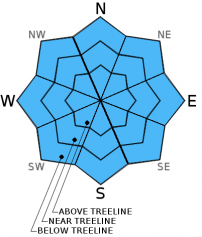
| Mid Slope Winds: | W | SW | E |
| Wind Speed: | 10 to 15 mph | 10 to 15 mph | 10 to 15 mph |
| Expected snowfall: | 0 | 0 | 0 |
For 8000 ft. to 9000 ft.
| Monday | Monday Night | Tuesday | |
|---|---|---|---|
| Weather: | Partly cloudy skies. | Partly cloudy skies. | Sunny skies. |
| Temperatures: | 44 to 54 deg. F. | 23 to 30 deg. F. | 46 to 52 deg. F. |
| Ridge Top Winds: | W | W to NW | NE |
| Wind Speed: | 15 to 20 mph with gusts to 35 mph. | 20 to 25 mph with gusts to 40 mph, decreasing to 10 to 15 mph with gusts to 25 mph after midnight. | 15 to 20 mph with gusts to 30 mph. |
| Expected snowfall: | 0 | 0 | 0 |


