


For 7000 ft. to 8000 ft.
| Saturday | Saturday Night | Sunday | |
|---|---|---|---|
| Weather: | Sunny | Clear | Sunny |
| Temperatures: | 24 to 29 deg. F. | 7 to 13 deg. F. | 25 to 30 deg. F. |
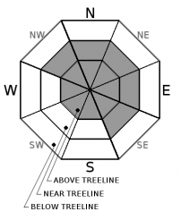
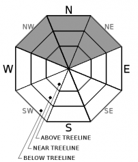
| Mid Slope Winds: | North | West shifting to the northeast after midnight | East |
| Wind Speed: | Light winds with gusts to 30 mph in the morning | Light | Light winds with gusts to 25 mph in the afternoon |
| Expected snowfall: | 0 | 0 | 0 |
For 8000 ft. to 9000 ft.
| Saturday | Saturday Night | Sunday | |
|---|---|---|---|
| Weather: | Sunny | Clear | Sunny |
| Temperatures: | 22 to 27 deg. F. | 11 to 16 deg. F. | 25 to 30 deg. F. |
| Ridge Top Winds: | North | West shifting to the northeast after midnight | East |
| Wind Speed: | 15 to 25 mph with gusts to 50 mph decreasing to gusts to 35 mph in the afternoon | 10 to 15 mph with gusts to 40 mph decreasing to gusts to 30 mph after midnight | 15 to 25 mph with gusts to 35 mph increasing to gusts to 45 mph in the afternoon |
| Expected snowfall: | 0 | 0 | 0 |


