THIS AVALANCHE FORECAST EXPIRED ON February 24, 2017 @ 6:59 am
Avalanche Forecast published on February 23, 2017 @ 6:59 am
Issued by Andy Anderson - Tahoe National Forest - Sierra Avalanche Center

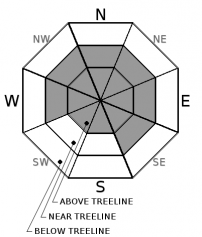
MODERATE avalanche danger exists in near and above treeline terrain today with LOW danger in below treeline areas. Human triggered wind slab avalanches and loose snow sluffs will remain possible today. Carefully evaluate snowpack and terrain before committing to any slopes and use this information to avoid slopes where avalanche problems may exist.

2. Moderate

?

Above Treeline
Heightened avalanche conditions on specific terrain features. Evaluate snow and terrain carefully; identify features of concern.

2. Moderate

?

Near Treeline
Heightened avalanche conditions on specific terrain features. Evaluate snow and terrain carefully; identify features of concern.

1. Low

?

Below Treeline
Generally safe avalanche conditions. Watch for unstable snow on isolated terrain features.
    Heightened avalanche conditions on specific terrain features. Evaluate snow and terrain carefully; identify features of concern.
Avalanche Problem 1: Wind Slab
  • Type ?
  • Aspect/Elevation ?
  • Likelihood ?
    Certain
    Very Likely
    Likely
    Possible
    Unlikely
  • Size ?
    Historic
    Very Large
    Large
    Small

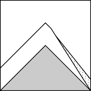
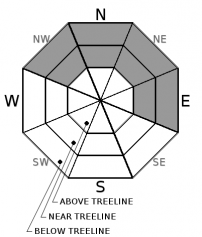
Human-triggerable wind slabs will remain possible on wind-loaded slopes in near and above treeline areas. The lingering wind slabs left over from the recent storm that exist on NW-N-NE-E-SE-S aspects will represent the largest of these wind slabs. Due to shifting winds today and yesterday some smaller wind slabs may exist on other aspects near ridgelines. Large fragile cornices also still exist along many of the ridgelines.

Use clues such as blowing snow, cornice formations, and wind pillows to help identify recently wind-loaded slopes where unstable wind slabs may exist. Then use this information to plan a backcountry travel route that avoids the potentially unstable wind-loaded slopes and utilizes more sheltered terrain where better snow for recreation will exist.

Avalanche Problem 2: Loose Dry
  • Type ?
  • Aspect/Elevation ?
  • Likelihood ?
    Certain
    Very Likely
    Likely
    Possible
    Unlikely
  • Size ?
    Historic
    Very Large
    Large
    Small

Some loose snow sluffs that involve the cold unconsolidated snow that exists in the upper foot of the snowpack could be possible today on steep sheltered slopes. Most of these would occur where the coldest and least cohesive snow exists on NW-N-NE-E aspects

recent observations

Observations on Silver Peak, Powderhouse Peak, and in the Horse Meadows/Blue Lakes area found little evidence of slab formation on near and below treeline sheltered slopes. Soft, cold, unconsolidated snow existed on the surface in in all three areas on sheltered slopes. Snowmobile cuts did produce a loose dry sluff on a steep test slope in the Horse Meadows area. In near and above treeline wind-exposed areas, wind affected snow existed in all three areas. Some slopes held scoured surfaces some held firm wind slabs and some held softer wind slabs. Cornices also existed on leeward aspects. On Powderhouse Peak, snowboard cuts did produce wind slab failures on some wind-loaded test slopes and shooting cracks on others. Ski cuts on wind-loaded test slopes on Silver Peak only produced small cracking and some sluffing in the new snow.  On Silver Peak and in the Blue Lakes area, observers noted some natural wind slab avalanches that had new snow covering the debris indicating that they likely occurred on Tuesday at the latest.

Weather and CURRENT CONDITIONS
weather summary

Mostly cloudy skies and a chance for some more scattered snow showers will continue today as a weak low pressure moves through the area. Snow accumulations should remain limited with only up to 5 inches predicted through tonight. By tomorrow chances for additional snow decrease and the winds should shift back to the southwest ahead of another storm system approaching the forecast area. Temperatures will remain cold with daytime highs in the teens and 20's and overnight lows in the single digits above 7000 ft. through tomorrow. 

CONDITIONS ALONG THE SIERRA CREST BETWEEN 8200 FT. AND 9200 FT. IN THE LAST 24 HOURS
6am temperature: 7 to 13 deg. F.
Max. temperature: 14 to 20 deg. F.
Average ridgetop wind direction: Southwest to northwest
Average ridgetop wind speed: 25 mph
Maximum ridgetop wind gust: 79 mph
New snowfall: 4 inches
Total snow depth: 140 to 190 inches
Two-Day Mountain Weather Forecast Produced in partnership with the Reno NWS
For 7000 ft. to 8000 ft.
Thursday Thursday Night Friday
Weather: Mostly cloudy with a 30% chance of scattered snow showers Mostly cloudy becoming partly cloudy with a 25% chance of scattered snow showers in the evening Partly cloudy becoming mostly cloudy with a 5% chance of snow showers in the afternoon
Temperatures: 21 to 26 deg. F. 2 to 10 deg. F. 24 to 29 deg. F.
Mid Slope Winds: West Variable Variable
Wind Speed: 10 to 15 mph in the morning becoming light in the afternoon Light Light
Expected snowfall: up to 2 up to 2 0
For 8000 ft. to 9000 ft.
Thursday Thursday Night Friday
Weather: Mostly cloudy with a 30% chance of scattered snow showers Mostly cloudy becoming partly cloudy with a 25% chance of scattered snow showers in the evening Partly cloudy becoming mostly cloudy with a 5% chance of snow showers in the afternoon
Temperatures: 16 to 24 deg. F. 4 to 9 deg. F. 20 to 26 deg. F.
Ridge Top Winds: Northwest North Southwest
Wind Speed: 10 to 15 mph with gusts to 35 mph 10 to 15 mph in the evening becoming light overnight. Gusts to 30 mph. Light in the morning increasing to 15 to 20 mph with gusts to 40 mph in the afternoon
Expected snowfall: up to 3 up to 2 0
Disclaimer

This avalanche advisory is provided through a partnership between the Tahoe National Forest and the Sierra Avalanche Center. This advisory covers the Central Sierra Nevada Mountains between Yuba Pass on the north and Ebbetts Pass on the south. Click here for a map of the forecast area. This advisory applies only to backcountry areas outside established ski area boundaries. This advisory describes general avalanche conditions and local variations always occur. This advisory expires 24 hours after the posted time unless otherwise noted. The information in this advisory is provided by the USDA Forest Service who is solely responsible for its content.

For a recorded version of the Avalanche Advisory call (530) 587-3558 x258