THIS AVALANCHE FORECAST EXPIRED ON February 10, 2017 @ 7:00 am
Avalanche Forecast published on February 9, 2017 @ 7:00 am
Issued by Andy Anderson - Tahoe National Forest - Sierra Avalanche Center

The avalanche danger will rise to CONSIDERABLE today at all elevations as hurricane force winds and heavy precipitation impact the region. Human triggered wind slab avalanches and wet loose avalanches will become likely today. As snow levels lower this afternoon and evening, wind slabs will become more widespread and larger and loose wet snow instabilities will become smaller and more isolated. Natural avalanches will become possible this afternoon and during the night as more snow accumulates. 

3. Considerable

?

Above Treeline
Dangerous avalanche conditions. Careful snowpack evaluation, cautious route-finding and conservative decision-making essential.

3. Considerable

?

Near Treeline
Dangerous avalanche conditions. Careful snowpack evaluation, cautious route-finding and conservative decision-making essential.

3. Considerable

?

Below Treeline
Dangerous avalanche conditions. Careful snowpack evaluation, cautious route-finding and conservative decision-making essential.
    Dangerous avalanche conditions. Careful snowpack evaluation, cautious route-finding and conservative decision-making essential.
Avalanche Problem 1: Wind Slab
  • Type ?
  • Aspect/Elevation ?
  • Likelihood ?
    Certain
    Very Likely
    Likely
    Possible
    Unlikely
  • Size ?
    Historic
    Very Large
    Large
    Small

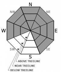
More snow and hurricane force winds will build new wind slabs on leeward aspects. The largest of these wind slabs will exist on wind-loaded N-NE-E aspects and cross-loaded SE and W-NW aspects above 8500 ft. where more precipitation falls as snow. As snow levels start to fall this afternoon and evening, wind slabs will form on lower elevation slopes and become larger and more widespread. Due to the strength of the winds at all elevations, wind slabs could exist in below treeline terrain as well as near and above treeline terrain. Human triggered wind slab avalanches will become likely on any slopes exposed to wind loading where significant snow accumulates today. Some natural wind slabs avalanches may become possible this afternoon and evening in areas where the most wind loading occurs. In areas where the precipitation falls as rain, wind slabs will be unlikely.

Looks for signs of recent wind loading such as cornice features and wind pillows to help identify where problematic wind slabs are likely to exist.

Avalanche Problem 2: Loose Wet
  • Type ?
  • Aspect/Elevation ?
  • Likelihood ?
    Certain
    Very Likely
    Likely
    Possible
    Unlikely
  • Size ?
    Historic
    Very Large
    Large
    Small

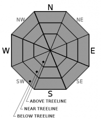
Wet loose avalanches and instabilities like point releases, pinwheels, and roller balls will remain possible today on steep slopes below 8500 ft. that receive additional rain. If snow levels climb higher than 8500 ft. these wet snow instabilities will become more widespread; if the snow levels fall lower than 8500 ft. the wet snow issues could become less widespread. Since the snowpack has well-established drainage to deal with the additional rain, wet slab avalanches remain unlikely, but they are not impossible in some areas. 

Most loose wet snow avalanches should remain small, but they could still knock a person off balance or cause a twisting fall. Be aware of terrain traps that could magnify the consequences of loose wet avalanches

recent observations

Yesterday observations on Tamarack Peak and Elephant's Hump revealed wet rain-soaked snow up to ~9500 ft. Some loose wet instabilities like point releases, roller balls, and pinwheels occurred on steep slopes. In both areas, evidence of well-established snowpack drainage existed including rain runnels up to ~9000 ft, free water flowing out of the bottom of the snowpack, and rapid increases in nearby stream flows. Ski cuts and cornices dropped onto steep test slopes did not trigger signs of instability. Settlement cracks, hand pits, and probing all also pointed to consolidation and settlement in the snowpack.

Weather and CURRENT CONDITIONS
weather summary

Another storm has arrived over the region with hurricane force southwest winds along the Sierra Crest. The winds will become stronger and more widespread today as this storm builds. Even winds at lower elevations could reach into the 40 to 60 mph range with gusts to 100 mph. At the upper elevations expect to see sustained wind speeds in the 60 to 80 mph range with gusts to145 mph. Winds should start to decrease some after midnight and into tomorrow. Rain and snow will increase over the region today with periods of heavy precipitation from midday onward. Most of today's precipitation should fall as 1 to 2 inches of rain below 8000 ft. due to snow levels that remain between 8000 and 8500 ft. for much of the day. Temperatures should start to cool this afternoon and evening and the forecast calls for snow levels to drop to around 7000 ft. tonight allowing for 6 to 12 inches of snow to accumulate. By tomorrow this storm should start to wind down and colder air should push into the region. Expect another 3 to 6 inches of snow tomorrow with snow levels at or below Lake Level. 

CONDITIONS ALONG THE SIERRA CREST BETWEEN 8200 FT. AND 9200 FT. IN THE LAST 24 HOURS
6am temperature: 37 to 40 deg. F.
Max. temperature: 39 to 43 deg. F.
Average ridgetop wind direction: South to southwest
Average ridgetop wind speed: 55 to 65 mph
Maximum ridgetop wind gust: 124 mph
New snowfall: Rain: 1.4 to 2 inches
Total snow depth: 110 to 147 inches
Two-Day Mountain Weather Forecast Produced in partnership with the Reno NWS
For 7000 ft. to 8000 ft.
Thursday Thursday Night Friday
Weather: Cloudy with a chance of rain in the morning. Rain becoming widespread this afternoon. Snow levels between 7500 and 8500 ft. Rain and snow. Snow level falling to 7000 ft. overnight Snow in the morning with snow decreasing in the afternoon
Temperatures: 43 to 49 deg. F. 27 to 33 deg. F. 33 to 38 deg. F.
Mid Slope Winds: Southwest Southwest Southwest
Wind Speed: 25 to 35 mph increasing to 40 to 60 mph with gusts to 100 mph 30 to 45 mph decreasing to 20 to 35 mph after midnight. Gusts to 60 mph in the evening 15 to 25 mph with gusts to 40 mph
Expected snowfall: Rain: .6-1.6 Rain: .6 to 1.6 in. | Snow: 6 to 12 3 to 6
For 8000 ft. to 9000 ft.
Thursday Thursday Night Friday
Weather: Cloudy with a chance of rain or snow in the morning. Rain and snow becoming widespread this afternoon. Snow levels between 7500 and 8500 ft. Snow Snow in the morning with snow decreasing in the afternoon
Temperatures: 35 to 43 deg. F. 24 to 29 deg. F. 28 to 33 deg. F.
Ridge Top Winds: Southwest Southwest Southwest
Wind Speed: 60 to 80 mph with gusts to 145 mph 45 to 60 mph with gusts to 135 mph decreasing to 35 to 50 mph with gusts to 120 mph after midnight 25 to 35 mph with gusts to 85 mph
Expected snowfall: Rain: .6 -1 in. | Snow: 4 to 8 6 to 12 3 to 6
Disclaimer

This avalanche advisory is provided through a partnership between the Tahoe National Forest and the Sierra Avalanche Center. This advisory covers the Central Sierra Nevada Mountains between Yuba Pass on the north and Ebbetts Pass on the south. Click here for a map of the forecast area. This advisory applies only to backcountry areas outside established ski area boundaries. This advisory describes general avalanche conditions and local variations always occur. This advisory expires 24 hours after the posted time unless otherwise noted. The information in this advisory is provided by the USDA Forest Service who is solely responsible for its content.

For a recorded version of the Avalanche Advisory call (530) 587-3558 x258