THIS AVALANCHE FORECAST EXPIRED ON January 27, 2017 @ 6:45 am
Avalanche Forecast published on January 26, 2017 @ 6:45 am
Issued by Steve Reynaud - Tahoe National Forest

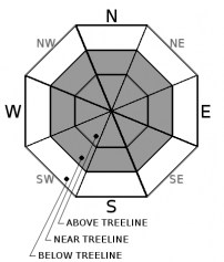
Moderate avalanche danger exists in near treeline and above treeline terrain due to the possibility of a wind slab avalanche problem.  Low avalanche danger continues in wind protected below treeline terrain.  Identify and avoid areas where active wind loading is occurring or has previously occurred.

2. Moderate

?

Above Treeline
Heightened avalanche conditions on specific terrain features. Evaluate snow and terrain carefully; identify features of concern.

2. Moderate

?

Near Treeline
Heightened avalanche conditions on specific terrain features. Evaluate snow and terrain carefully; identify features of concern.

1. Low

?

Below Treeline
Generally safe avalanche conditions. Watch for unstable snow on isolated terrain features.
    Heightened avalanche conditions on specific terrain features. Evaluate snow and terrain carefully; identify features of concern.
Avalanche Problem 1: Wind Slab
  • Type ?
  • Aspect/Elevation ?
  • Likelihood ?
    Certain
    Very Likely
    Likely
    Possible
    Unlikely
  • Size ?
    Historic
    Very Large
    Large
    Small

Wind slabs are possible on all aspects in near treeline and above treeline terrain on slopes 35 degrees and steeper.  SW/W winds began to increase in speed yesterday afternoon to the moderate range with gusts into the strong range.  These winds continued on and off throughout the night and are forecasted to shift to the North today and remain in the moderate to strong range.  Plenty of recent storm snow is available for transport if wind speeds do materialize.

Look for active signs of wind loading including blowing snow, cornice formation, and wind pillows.  Snow surface scouring may offer clues as to how much wind transport previously occurred overnight as wind direction and speed change today.

recent observations

Observations were made and received from Hidden Peak (West Shore area) and Castle Peak (Donner Summit area).  Both areas showed that the recent storm snow continues to settle and gain strength.  On Hidden Peak, very little wind with no wind transport of snow was observed along the summit ridge.  Winds did increase in speed by early afternoon in this area.  Snowpack tests and informal observations gave no indications of ongoing instabilities within the snowpack.

Weather and CURRENT CONDITIONS
weather summary

Light snow showers are possible throughout the day with minimal accumulations expected.  Winds will shift from the SW/W to N today and be in the moderate to strong range.  Strong high pressure will build into the area tonight and through the weekend with warming conditions and valley inversions.  A return to unsettled weather is possible by Wednesday of next week.

CONDITIONS ALONG THE SIERRA CREST BETWEEN 8200 FT. AND 9200 FT. IN THE LAST 24 HOURS
6am temperature: 13 to 20 deg. F.
Max. temperature: 26 deg. F.
Average ridgetop wind direction: SW to W
Average ridgetop wind speed: 15 to 25 mph
Maximum ridgetop wind gust: 38 mph
New snowfall: Trace to 1 inches
Total snow depth: 115 to 139 inches
Two-Day Mountain Weather Forecast Produced in partnership with the Reno NWS
For 7000 ft. to 8000 ft.
Thursday Thursday Night Friday
Weather: Mostly cloudy. Isolated snow showers in the morning then scattered snow showers in the afternoon. Mostly cloudy then becoming clear. Slight chance of snow showers in the evening. Sunny.
Temperatures: 23 to 28 deg. F. 9 to 15 deg. F. 29 to 30 deg. F.
Mid Slope Winds: E
Wind Speed: Light winds. Light winds becoming East 10 to 15mph with gusts to 30mph after midnight. Light winds. Gusts up to 30mph in the morning.
Expected snowfall: Trace 0 0
For 8000 ft. to 9000 ft.
Thursday Thursday Night Friday
Weather: Mostly cloudy. Isolated snow showers in the morning then scattered snow showers in the afternoon. Mostly cloudy then becoming clear. Slight chance of snow in the evening. Sunny
Temperatures: 19 to 25 deg. F. 8 to 13 deg. F. 29 to 34 deg. F.
Ridge Top Winds: N NE shifting to E. E
Wind Speed: 15 to 20mph with gusts to 40mph. 15 to 20mph shifting to the East 20 to 30mph after midnight. Gusts up to 55mph. 15 to 20mph with gusts to 45mph.
Expected snowfall: Trace 0 0
Disclaimer

This avalanche advisory is provided through a partnership between the Tahoe National Forest and the Sierra Avalanche Center. This advisory covers the Central Sierra Nevada Mountains between Yuba Pass on the north and Ebbetts Pass on the south. Click here for a map of the forecast area. This advisory applies only to backcountry areas outside established ski area boundaries. This advisory describes general avalanche conditions and local variations always occur. This advisory expires 24 hours after the posted time unless otherwise noted. The information in this advisory is provided by the USDA Forest Service who is solely responsible for its content.

For a recorded version of the Avalanche Advisory call (530) 587-3558 x258