In partnership with: 
|
December 29, 2012 at 8:01 am |
|
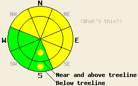
MODERATE avalanche danger exists today on slopes steeper than 35 degrees in both above and below treeline on NW-N-NE-E-SE aspects with pockets of MODERATE danger on the S aspects. Heavy snow loads sitting on top of weak persistent deep slabs will allow large destructive human triggered avalanches to remain possible. Even though these avalanches have become less likely, the consequences of such a slide would be very high. |
|
|
|
Another weak low pressure moving down the east side of the Sierra should keep temperatures cold and winds light for through tomorrow afternoon. This low should also bring light snow showers to the area over the next 24 hours. The forecast calls for snow amounts between 0 and 4 inches with the mountains south and east of Lake Tahoe receiving the most snowfall. The snow showers should decrease on Sunday as a small high pressure ridge begins to replace the low pressure.
Settlement and consolidation continued in the upper snowpack yesterday. Snowpit data and observations from Third Creek (snowpit, more info), Castle Peak (photos, more info), Andesite Ridge (photos, more info), Echo Summit (more info), and Rubicon Peak (more info) all showed that a strong snowpack exists above the deeply buried persistent weak layers. Ski cuts and pieces of cornice dropped onto steep test slopes in the Third Creek area, on Castle Peak, and Andesite Ridge did not reveal any signs on instability. In the Echo Summit area some minor surface sluffing did occur on steep N facing slopes; however observers reported no other signs of instability. 180-220 cm (5-7 ft) below all of this strong snow the old weak layers still exist in the form of a facet layer above a rain crust (Dec. 12th facets) and a facet layer below the rain crust (Dec. 2nd facets). The strong snow above these layers has made it less likely for a single person to cause a failure in these old persistent weak layers. However, tests on these layers near Kirkwood showed that they can still fail when a larger trigger hits the slope. When these old layers do fail, very large, deep, and destructive avalanches occur.
Reports of avalanches that occurred between Dec 24th and Dec 26th continue to trickle in. As these reports come in, the details will appear on the observations page (photos from Pole Creek).
Avalanche Problem #1: Persistent Deep Slabs
It has become less likely for a single person on a slope to cause a failure in the persistent weak layers represented by the Dec. 2nd and Dec. 12th facets because of the 4-7 ft of strong cohesive snow resting above these layers. However, larger triggers such as multiple people on a slope, other avalanches, or large cornice collapses could cause failures in these deep weak layers. The resulting avalanches would fracture across wide areas and could easily propagate far above or far to the side of the trigger. The most well developed and weakest facets exist on NW-N-NE aspects between 7,500 ft. and 10,000 ft. However, they have been noted on some southerly and easterly aspects as well. Variability in the strength and distribution of the persistent weak layers means uncertainty remains as to exactly where and when persistent deep slab failure could occur. In summary, triggering an avalanche on these deeply buried layers has become less likely, but if one does occur it will be very large, deep, destructive, and dangerous.
Avalanche Problem #2: Wind Slabs
Tests, observations, and other data indicate that the upper sections of the snowpack have consolidated. Triggering an avalanche due to a failure in the upper snowpack will be unlikely today in most areas. However, some fragile wind slabs may still exist on very isolated wind loaded slopes in complex or extreme terrain or on unsupported slopes. Human triggered avalanches involving these slabs remain possible in these very isolated areas. The largest and most fragile wind slabs will exist on wind loaded and cross loaded NW-N-NE-E-SE aspects.
MODERATE avalanche danger exists today on slopes steeper than 35 degrees in both above and below treeline on NW-N-NE-E-SE aspects with pockets of MODERATE danger on the S aspects. Heavy snow loads sitting on top of weak persistent deep slabs will allow large destructive human triggered avalanches to remain possible. Even though these avalanches have become less likely, the consequences of such a slide would be very high.
| 0600 temperature: | 14-20 deg. F. |
| Max. temperature in the last 24 hours: | 16-24 deg. F. |
| Average wind direction during the last 24 hours: | Southwest |
| Average wind speed during the last 24 hours: | 0-15 mph |
| Maximum wind gust in the last 24 hours: | 40 mph |
| New snowfall in the last 24 hours: | 0-2 inches |
| Total snow depth: | 65-91 inches |
For 7000-8000 ft: |
|||
| Saturday: | Saturday Night: | Sunday: | |
| Weather: | Cloudy with 40% chance of scattered snow showers | Cloudy with a 25% chance of light snow showers | Mostly cloudy with a 20% chance of snow flurries with clouds and snow decreasing in the afternoon |
| Temperatures: | 19-26 deg. F. | 6-13 deg. F. | 15-22 deg. F. |
| Wind direction: | Variable | Variable | Variable |
| Wind speed: | Light | Light | Light |
| Expected snowfall: | up to 1 in. | up to 1 in. | O in. |
For 8000-9000 ft: |
|||
| Saturday: | Saturday Night: | Sunday: | |
| Weather: | Cloudy with 40% chance of scattered snow showers | Cloudy with a 25% chance of light snow showers | Mostly cloudy with a 20% chance of snow flurries with clouds and snow decreasing in the afternoon |
| Temperatures: | 14-21 deg. F. | 4-11 deg. F. | 10-17 deg. F. |
| Wind direction: | Variable | West | Northeast |
| Wind speed: | Light | Light becoming 10-15 mph with gusts to 25 mph after midnight | 10-15 mph |
| Expected snowfall: | up to 1 in. | up to 1 in. | O in. |


This website is owned and maintained by the non-profit arm of the Sierra Avalanche Center. Some of the content is updated by the USDA avalanche forecasters including the forecasts and some observational data. The USDA is not responsible for any advertising, fund-raising events/information, or sponsorship information, or other content not related to the forecasts and the data pertaining to the forecasts.

