In partnership with: 
| Date and time of observation or avalanche occurrence | Location | Media | Observation made by |
|---|---|---|---|
|
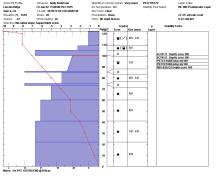
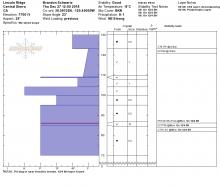
01/02/2015 - 11:15 Snowpack Observation |
Lincoln Ridge Yuba Pass Area |
 |
Forecaster |
|
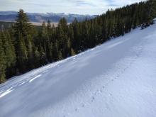
11/28/2022 - 11:00 Snowpack Observation |
Lincoln Ridge Yuba Pass Area |
   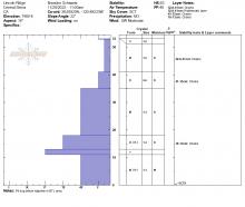 |
Forecaster |
|
01/04/2019 - 11:15 Snowpack Observation |
Lincoln Ridge Yuba Pass Area |
   |
Forecaster |
|
01/04/2021 - 12:00 Avalanche Observation |
Lincoln Ridge Yuba Pass Area |
    |
Forecaster |
|
12/02/2021 - 11:00 Snowpack Observation |
Lincoln Ridge Yuba Pass Area |
    |
Forecaster |
|
12/17/2017 - 12:30 Snowpack Observation |
Lincoln Ridge Yuba Pass Area |
     |
Forecaster |
|
12/15/2020 - 09:15 Snowpack Observation |
Above long creek Yuba Pass Area |
   |
Public |
|
02/19/2012 - 12:30 Snowpack Observation |
Lincoln Ridge Yuba Pass Area |
 |
Forecaster |
|
12/06/2018 - 11:45 Snowpack Observation |
Lincoln Ridge Yuba Pass Area |
     |
Forecaster |
|
11/29/2016 - 11:00 Snowpack Observation |
Lincoln Ridge Yuba Pass Area |
    |
Forecaster |
|
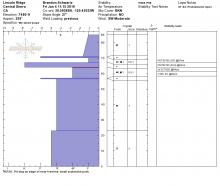
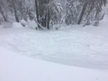
11/18/2022 - 10:55 Snowpack Observation |
Lincoln Ridge Yuba Pass Area |
    |
Forecaster |
|
02/28/2021 - 11:00 Snowpack Observation |
Lincoln Ridge Yuba Pass Area |
   |
Forecaster |
|
12/27/2018 - 12:00 Snowpack Observation |
Lincoln Ridge Yuba Pass Area |
     |
Forecaster |
|
03/27/2016 - 12:00 Snowpack Observation |
Lincoln Ridge Yuba Pass Area |
   |
Forecaster |
|
03/27/2017 - 10:30 Snowpack Observation |
Lincoln Ridge Yuba Pass Area |
   |
Forecaster |


This website is owned and maintained by the non-profit arm of the Sierra Avalanche Center. Some of the content is updated by the USDA avalanche forecasters including the forecasts and some observational data. The USDA is not responsible for any advertising, fund-raising events/information, or sponsorship information, or other content not related to the forecasts and the data pertaining to the forecasts.

