In partnership with: 
| Date and time of observation or avalanche occurrence | Location | Media | Observation made by |
|---|---|---|---|
|
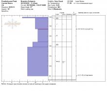
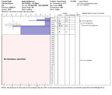
03/13/2020 - 03:00 Snowpack Observation |
Incline Peak Mount Rose Area |
 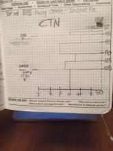  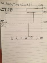 |
Public |
|
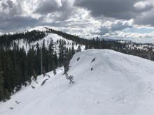
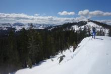
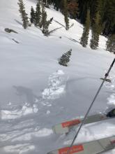
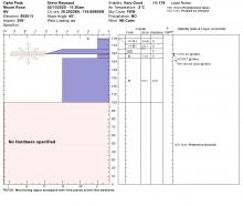
03/12/2020 - 11:30 Snowpack Observation |
Powderhouse Peak Luther Pass Area (including Job and Freel) |
|
Forecaster |
|
03/11/2020 - 13:00 Snowpack Observation |
Castle Peak Donner Summit Area |
    |
Forecaster |
|
03/11/2020 - 11:45 Snowpack Observation |
Ophir Peak Mount Rose Area |
  |
Forecaster |
|
03/10/2020 - 12:00 Snowpack Observation |
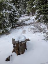
Elephant's Back Carson Pass Area |
  |
Professional Observer |
|
03/10/2020 - 12:00 Snowpack Observation |
Tamarack Peak Mount Rose Area |
     |
Forecaster |
|
03/09/2020 - 12:15 Snowpack Observation |
Stevens Peak Carson Pass Area |
      |
Professional Observer |
|
03/09/2020 - 11:30 Snowpack Observation |
Silver Peak Cabin Creek, Deep Creek, or Pole Creek Area |
      |
Forecaster |
|
03/08/2020 - 13:00 Snowpack Observation |
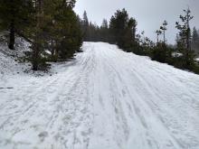
Slide mountain Mount Rose Area |
  |
Public |
|
03/08/2020 - 12:00 Snowpack Observation |
Lincoln Ridge - Yuba Pass Yuba Pass Area |
    |
Forecaster |
|
03/07/2020 - 20:00 Snowpack Observation |
Blue Lakes Carson Pass Area |
Public | |
|
03/07/2020 - 15:30 Snowpack Observation |
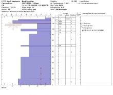
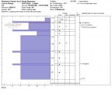
LTCC Avy 2 elephant hump pit Carson Pass Area |
 |
Public |
|
03/07/2020 - 14:30 Snowpack Observation |
Red Lake State Park Carson Pass Area |
 |
Public |
|
03/07/2020 - 11:30 Snowpack Observation |
Andesite Peak Donner Summit Area |
   |
Forecaster |
|
03/06/2020 - 15:30 Snowpack Observation |
Blue Lakes near border ruffian Carson Pass Area |
Public |


This website is owned and maintained by the non-profit arm of the Sierra Avalanche Center. Some of the content is updated by the USDA avalanche forecasters including the forecasts and some observational data. The USDA is not responsible for any advertising, fund-raising events/information, or sponsorship information, or other content not related to the forecasts and the data pertaining to the forecasts.


