These observations document past conditions at a small and variable scale. They are not to be confused with an avalanche forecast. They come from a variety of sources. We can only vouch for the quality of those produced by the SAC forecasters and professional observers.
Date and time of observation or avalanche occurrence Location Media Observation made by
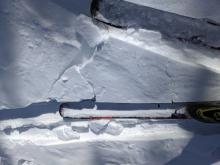
02/18/2023 - 13:52

Snowpack Observation
Trees east of Polaris bowl

Carson Pass Area
Snow pit test CT20 SP 25cm down Q1 block on column test Public
02/18/2023 - 13:00

Snowpack Observation
Castle Peak

Donner Summit Area
Wind-affected snow surfaces were widespread on Castle Peak. Minor cracking in an area of shallow wind drifted snow. The north side of Castle Peak looked wind-hammered and firm. Settlement cones indicating consolidation in the snowpack. About an inch of soft wet snow on S-SW aspects at 12:30. Cloud cover moved into the area around 1 pm. Forecaster
02/17/2023 - 11:15

Snowpack Observation
Elephants Hump

Carson Pass Area
ECTX when testing the upper snowpack on a sheltered NE aspect below treeline. Soft snow in sheltered areas below treeline and wind affected snow on the ridges. Minor cracking in a shallow deposit of wind blown snow. Wind shaped surfaces on the ridge. Wind scoured surfaces and raised tracks near the top of Elephant's Hump Looking out at Elephant's Back and the surrounding mountains. Forecaster
02/16/2023 - 15:20

Snowpack Observation
Polaris Bowl

Carson Pass Area
Test results indicated reactive wind slabs would be very localized, small, and shallow Reactive wind slab was only a few inches thick. Graupel was observed a few more inches below the ECT failure Graupel seen in all four ECT locations, but not reactive in any of them Light wind transport observed Professional Observer
02/16/2023 - 11:38

Snowpack Observation
Small wind slabs near Frog Lake.

Carson Pass Area
High cirrus clouds reducing solar radiation. Small wind slab on isolated feature. Old/new cornice development. 3cm layer of graupel. 5mm graupel within layer. Small wind slab with minimal cracking. Professional Observer
02/15/2023 - 15:30

Snowpack Observation
Powderhouse

Luther Pass Area (including Job and Freel)
Public
02/15/2023 - 12:00

Snowpack Observation
Stevens Peak

Carson Pass Area
No current wind transport observed on Stevens Peak, and previously wind loaded test slopes did not produce results Compression test with a Sudden Planar result on Jan 29th SH on the 30th tap, and and ECT that propagated beyond 30 loading steps. Snow was removed from above the Jan 29th layer after performing the tests Small near crust facets under the most recent surface crust Professional Observer
02/15/2023 - 12:00

Snowpack Observation
Stanford Rock

Blackwood Canyon or Ward Canyon Area
Blowing snow over the Sierra Crest from strong to gale force NE winds Some cracking in wind loaded terrain when undercut by skin track on 6 to 8'' wind slab. Up to 3'' skin track refill within 1.5 hours. Wind scouring in exposed areas NTL terrain. ECTN on Jan 29 buried SH layer at this location. Forecaster
02/15/2023 - 11:04

Snowpack Observation
Variable conditions on Pickett Peak

Luther Pass Area (including Job and Freel)
Wind effected snow on exposed areas in below tree line terrain. One mighty inch of snow from yesterday. Planar results @ 20cm down on NSF below recent snow. Dry unconsolidated near surface facets. Breakable melt freeze crusts on solar aspects below tree line. Professional Observer
02/14/2023 - 12:00

Snowpack Observation
Elephant's Hump

Carson Pass Area
Shooting crack on a wind loaded feature Removing the snow below the crack was easy and clean Every wind loaded feature we tested today produced shooting cracks Professional Observer
02/14/2023 - 11:00

Snowpack Observation
Deep Creek

Cabin Creek, Deep Creek, or Pole Creek Area
Light snowfall at midday. Breakable crust in areas of previous wind exposure. 2 inch thick melt-freeze crust on S aspect of a micro terrain feature. Only a 1 inch thick wind slab below this cornice area with no results on a test slope ski cut. Forecaster
02/14/2023 - 11:00

Snowpack Observation
Elephants Hump

Carson Pass Area
Public
02/14/2023 - 01:00

Snowpack Observation
Incline Lake Peak

Mount Rose Area
A short break in the clouds and light snow around midday. A dusting of snow accumulation around 1cm. Low cloud ceiling throughout most of the day with light snow. Forecaster
02/13/2023 - 12:00

Snowpack Observation
Schallenberger Ridge

Donner Summit Area
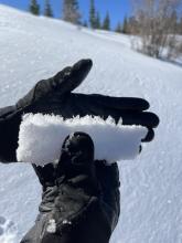
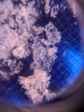
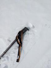
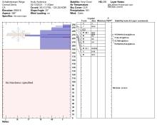
Our ECT did not show signs of instability (ECTN), nor did the PST indicate that this layer might still remain active (PST 68/100 END) The Jan 29th surface hoar layer was clearly visible in the snowpack. This layer had 8-10mm surface hoar. A close up view of the buried surface hoar. 1 inch of wet snow on top of a crust on a sunny SE aspect. Forecaster
02/13/2023 - 11:00

Snowpack Observation
Rubicon Peak

West Shore Area
NW winds drifting snow near the summit with little to no new wind slab formation. S aspect micro terrain feature at 8,000'. Most recent storm snow fully wet and assimilating with the melt-freeze crust below. Moist surface snow on N aspect terrain at 8,500'. Wet surface snow on low angle N aspect terrain at 7,400'. SE face of Crag Peak showing very limited amounts of roller ball activity. Forecaster

Pages