THIS AVALANCHE FORECAST EXPIRED ON December 8, 2013 @ 6:51 am
Avalanche Forecast published on December 7, 2013 @ 6:51 am
Issued by Brandon Schwartz - Tahoe National Forest

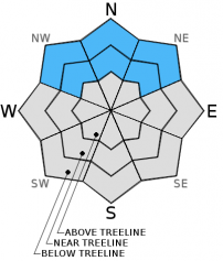
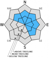
Widespread areas of CONSIDERABLE avalanche danger exist near and above treeline on NW-N-NE-E-SE aspects 30 degrees and steeper due to newly formed wind slabs and below treeline on NW-N-NE aspects 30 degrees and steeper due to persistent slabs. Natural avalanches are possible, human triggered avalanches are likely today. Significant avalanche danger exists below treeline. --- Everyone is chomping at the bit to get out there today. Only a small percentage have a handle on the weakness of the existing snowpack and the reality of avalanches today. Conservative terrain selection and effective group communication are imperative.

3. Considerable

?

Above Treeline
Dangerous avalanche conditions. Careful snowpack evaluation, cautious route-finding and conservative decision-making essential.

3. Considerable

?

Near Treeline
Dangerous avalanche conditions. Careful snowpack evaluation, cautious route-finding and conservative decision-making essential.

3. Considerable

?

Below Treeline
Dangerous avalanche conditions. Careful snowpack evaluation, cautious route-finding and conservative decision-making essential.
    Dangerous avalanche conditions. Careful snowpack evaluation, cautious route-finding and conservative decision-making essential.
Avalanche Problem 1: Persistent Slab
  • Type ?
  • Aspect/Elevation ?
  • Likelihood ?
    Certain
    Very Likely
    Likely
    Possible
    Unlikely
  • Size ?
    Historic
    Very Large
    Large
    Small

The areas that held the greatest amount of snow cover prior to last night's snowfall also hold the greatest hazard today. The near treeline and below treeline areas have many weak layers in the form of basal facets, near crust facets, near surface facets, and surface hoar. New snow loading on top of these persistent weak layers will allow for the possibility of natural and human triggered avalanches today. Wide propagation and avalanche activity on lower angle slopes to around 30 degrees are likely today below treeline. Anyone who is thinking that they will avoid avalanches today simply by staying in the trees is greatly mistaken. 

Avalanche Problem 2: Wind Slab
  • Type ?
  • Aspect/Elevation ?
  • Likelihood ?
    Certain
    Very Likely
    Likely
    Possible
    Unlikely
  • Size ?
    Historic
    Very Large
    Large
    Small

Near and above treeline, wind loading on NW-N-NE-E-SE aspects is expected to have created fresh wind slabs. Due to previous wind scouring, these new slabs are forming on top of just a few inches of old snow in most areas. Avalanche activity that occurs in these areas is most likely to occur within the storm snow. In isolated areas below cliff bands on NW-N-NE aspects, more old snow exists above treeline with the potential for more active weak layers within the older snowpack.

recent observations

The snowpack so far this season has been built a few inches at at time, not feet at a time in typical Sierra fashion. As a result the existing snowpack is weak with many weak layers. It is more like a snowpack that is commonly experienced in the Rockies, Tetons, or Wasatch than in the Sierra Nevada.

Observations collected from around the forecast area over the past few weeks have shown that the existing snowpack is weak and in poor condition to handle new snow loading. Near treeline and below treeline areas that are above 7,500' on NW-N-NE aspects held 1 to 2 feet of weak faceted (sugary) snow, eroding crusts, and surface hoar prior to the current snowfall. The vast majority of above treeline areas were significantly scoured by ENE winds Nov 21-23, removing most of the previous snow cover.

Observations made yesterday below Grouse Rocks (Ward Canyon area) revealed multiple weak layers within the snowpack on northerly aspects. Surface hoar was prevalent in open areas below treeline. Near crust facets on top of the upper most crust in the snowpack produced propagating failures in snowpit tests. For the most part, a significant slab was absent from above the most problematic weak layers yesterday (video, photo, pit profile, more info). Now that significant amounts of new snow have been added overnight, the slab is now there and additional load has been placed on these weak layers.

Weather and CURRENT CONDITIONS
weather summary

The storm system currently impacting the forecast area is expected to bring continued snowfall this morning before starting to taper down this afternoon. Remote sensors are reporting new snow amounts of 12 to 18 inches above 7,000'. An additional 2 to 8 inches are expected today. Ridgetop winds out of the southwest are moderate to strong in speed. Winds are forecast to decrease to moderate in speed this afternoon, eventually shifting to the north by tomorrow morning. Air temperatures are generally in the upper single digits to teens this morning for locations above 7,000'. Little to no daytime warming is expected as cold air is left in the wake of the cold front associated with the current weather system.

CONDITIONS ALONG THE SIERRA CREST BETWEEN 8200 FT. AND 9200 FT. IN THE LAST 24 HOURS
6am temperature: 8 to 14 deg. F.
Max. temperature: 13 to 22 deg. F.
Average ridgetop wind direction: SW
Average ridgetop wind speed: 28 mph
Maximum ridgetop wind gust: 73 mph
New snowfall: 12 to 18 inches
Total snow depth: 22 to 36 inches
Two-Day Mountain Weather Forecast Produced in partnership with the Reno NWS
For 7000 ft. to 8000 ft.
Saturday Saturday Night Sunday
Weather: Cloudy skies with snow in the morning. Snow likely in the afternoon. Mostly cloudy skies, becoming partly cloudy. Partly cloudy skies.
Temperatures: 8 to 15 deg. F. -7 to 0 deg. F. 12 to 19 deg. F.
Mid Slope Winds: SW shifting to W W NE
Wind Speed: 35 to 40 mph with gusts to 60 mph, shifting and decreasing to 20 to 25 mph with gusts to 35 mph in the afternoon. 15 to 20 mph. Gusts up to 30 mph after midnight. 20 to 25 mph with gusts to 30 mph, decreasing to 10 to 15 mph with gusts to 25 mph in the afternoon.
Expected snowfall: 1 to 8 Trace to 2 0
For 8000 ft. to 9000 ft.
Saturday Saturday Night Sunday
Weather: Cloudy skies with snow. Mostly cloudy skies, becoming partly cloudy. Slight chance of snow. Partly cloudy skies.
Temperatures: 7 to 13 deg. F. -6 to 1 deg. F. 15 to 21 deg. F.
Ridge Top Winds: SW shifting to W NW N
Wind Speed: 55 to 60 mph with gusts to 95 mph, shifting and decreasing to 35 to 40 mph with gusts to 60 mph in the afternoon. 20 to 30 mph with gusts to 40 mph. 30 to 35 mph with gusts to 50 mph, decreasing to 20 to 25 mph with gusts to 40 mph in the afternoon.
Expected snowfall: 2 to 8 Trace to 3 0
Disclaimer

This avalanche advisory is provided through a partnership between the Tahoe National Forest and the Sierra Avalanche Center. This advisory covers the Central Sierra Nevada Mountains between Yuba Pass on the north and Ebbetts Pass on the south. Click here for a map of the forecast area. This advisory applies only to backcountry areas outside established ski area boundaries. This advisory describes general avalanche conditions and local variations always occur. This advisory expires 24 hours after the posted time unless otherwise noted. The information in this advisory is provided by the USDA Forest Service who is solely responsible for its content.