THIS AVALANCHE FORECAST EXPIRED ON December 9, 2013 @ 6:41 am
Avalanche Forecast published on December 8, 2013 @ 6:41 am
Issued by Andy Anderson - Tahoe National Forest - Sierra Avalanche Center

CONSIDERABLE avalanche danger exists at all elevations on NW-N-NE aspects 30 degrees and steeper due to a combination of lingering wind slabs and widespread persistent slabs. Human triggered avalanches remain likely today especially in near and below treeline areas where the persistent slabs exist and in above treeline areas where wind slabs sit on persistent weak layers. Remotely triggered avalanches can occur under these conditions. In addition to the avalanche danger a myriad of season-ending obstacles still lurks just below the surface. Don't let "powder-fever" cloud your judgement. Conservative terrain selection, careful snowpack evaluation, and conservative decision-making are essential.

3. Considerable

?

Above Treeline
Dangerous avalanche conditions. Careful snowpack evaluation, cautious route-finding and conservative decision-making essential.

3. Considerable

?

Near Treeline
Dangerous avalanche conditions. Careful snowpack evaluation, cautious route-finding and conservative decision-making essential.

3. Considerable

?

Below Treeline
Dangerous avalanche conditions. Careful snowpack evaluation, cautious route-finding and conservative decision-making essential.
    Dangerous avalanche conditions. Careful snowpack evaluation, cautious route-finding and conservative decision-making essential.
Avalanche Problem 1: Persistent Slab
  • Type ?
  • Aspect/Elevation ?
  • Likelihood ?
    Certain
    Very Likely
    Likely
    Possible
    Unlikely
  • Size ?
    Historic
    Very Large
    Large
    Small

Any areas that had snow cover prior to this storm remain suspect. The weak layers below the new snow still exist and will not go away anytime soon. As the new snow starts to consolidate, it will become more cohesive and slab-like. More of a slab on top of those buried Dec. 7th facets means triggering avalanches remains likely. In fact it may be easier to trigger these kind of avalanches today. Since fractures can travel so easily through the persistant weak layer, people can trigger persistent slabs remotely while standing in low angle terrain or on ridgelines or anywhere that the snowpack under thier feet connects to steeper and/or deeper terrain. Wide propagation and avalanche activity on lower angle slopes to around 30 degrees remains likely today below treeline.

Avalanche Problem 2: Wind Slab
  • Type ?
  • Aspect/Elevation ?
  • Likelihood ?
    Certain
    Very Likely
    Likely
    Possible
    Unlikely
  • Size ?
    Historic
    Very Large
    Large
    Small

The wind slabs that formed during the storm still remain on the near and above treeline NW-N-NE-E-SE aspects. In many areas these winds slabs formed on top of wind scoured slopes that held a mix of rocks, dirt, and a few inches of old snow. However, some of these wind slabs could sit on top of the persistent weak layers mentioned above on the NW-N-NE aspects that did not get as scoured. Human triggered avalanche activity resulting from the failure of these wind slabs remains likely on slopes where the persistent weak layers exist and possible on slopes that just hold wind slabs.

recent observations

Yesterday widespread cracking, whumphing, and collapsing occurred on N-NE aspects in the Mt. Rose area (photo, more info) and on Silver Peak (photos, snowpit, more info). These cracks, whumphs, and other failures occurred as the layer of weak sugary snow grains (facets formed before the storm - now the "Dec. 7th facets") collapsed under the combined weight of the new snow and a person. In some areas enough anchors (stumps, bushes, logs, trees, rocks, etc.) existed to prevent the collapses from traveling too far. Of course these same barely covered anchors also prevented people from traveling easily in those areas. In places with more snow cover these collapses propagated along the Dec. 7th facets for much longer distances, and in several cases shooting cracks shattered entire low angle slopes (photos). These failures could initiate in areas where less snow existed or in low angle terrain and travel into deeper and steeper terrain. On Silver Peak one of these collapses occurred as a skier weighted a shallow area of snow on a ridgeline that the E winds had partially scoured before the storm. This collapse traveled down slope and fractured an area below the ridge where more snow existed.

Weather and CURRENT CONDITIONS
weather summary

Another 2-5 inches of new snow fell yesterday with the greatest amounts accumulating south of Hwy. 50. This additional snowfall brings the storm total to 14-22 inches of light, cold snow. As the storm exited the area, skies cleared, winds decreased, and temperatures dropped. This morning lows above 8000 ft remain near zero with the mountain valleys and lower elevations reporting negative temperatures. The cold clear weather should continue as a high pressure ridge starts to build over the region. Some warming should begin during the next few days in the mountains. Above 7000 the forecast calls for temperatures to climb into the 20's tomorrow. Cold air trapped in the valleys should keep the lower elevations cooler. The winds should also begin to increase and shift to the East and Northeast today as the high pressure moves this direction.

CONDITIONS ALONG THE SIERRA CREST BETWEEN 8200 FT. AND 9200 FT. IN THE LAST 24 HOURS
6am temperature: -4 to 4 deg. F.
Max. temperature: 4 to 12 deg. F.
Average ridgetop wind direction: Southwest
Average ridgetop wind speed: Before midnight: 25-35 mph | After midnight: 5-15 mph
Maximum ridgetop wind gust: 65 mph
New snowfall: North of Hwy 50: 1-2 inches | South of Hwy 50: 2-5 inches
Total snow depth: 20-34 inches
Two-Day Mountain Weather Forecast Produced in partnership with the Reno NWS
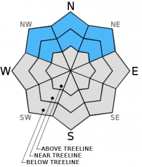
For 7000 ft. to 8000 ft.
Sunday Sunday Night Monday
Weather: Mostly sunny Clear Sunny
Temperatures: 10-19 deg. F. 2-8 deg. F. 22-27 deg. F.
Mid Slope Winds: Variable in the morning shifting to the East in the afternoon East East
Wind Speed: 10 mph increasing to 10-15 mph in the afternoon 10-20 mph with gusts to 30 mph 15-20 mph with gusts to 35 mph decreasing to 10-15 mph in the afternoon
Expected snowfall: 0 0 0
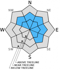
For 8000 ft. to 9000 ft.
Sunday Sunday Night Monday
Weather: Mostly sunny Clear Sunny
Temperatures: 8-15 deg. F. 5-10 deg. F. 22-27 deg. F.
Ridge Top Winds: Northwest shifting to the Northeast in the afternoon Northeast Northeast shifting to the East in the afternoon
Wind Speed: 15-25 mph with gusts to 40 mph 20-35 mph with gusts to 55 mph 20-35 mph with gusts to 60 mph decreasing to 15-25 mph with gusts to 40 mph in the afternoon
Expected snowfall: 0 0 0
Disclaimer

This avalanche advisory is provided through a partnership between the Tahoe National Forest and the Sierra Avalanche Center. This advisory covers the Central Sierra Nevada Mountains between Yuba Pass on the north and Ebbetts Pass on the south. Click here for a map of the forecast area. This advisory applies only to backcountry areas outside established ski area boundaries. This advisory describes general avalanche conditions and local variations always occur. This advisory expires 24 hours after the posted time unless otherwise noted. The information in this advisory is provided by the USDA Forest Service who is solely responsible for its content.