


For 7000 ft. to 8000 ft.
| Thursday | Thursday Night | Friday | |
|---|---|---|---|
| Weather: | Sunny | Partly Cloudy | Partly Cloudy |
| Temperatures: | 40-45 deg. F. | 23-38 deg. F. | 29-33 deg. F. |
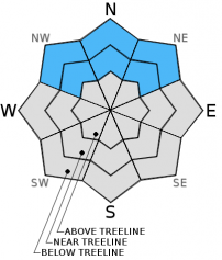
| Mid Slope Winds: | SW | W | NW shifting to the NE in the afternoon |
| Wind Speed: | up to 10 mph in the morning, increasing to 10-15 mph in the afternoon | 10-15 mph with gusts to 25 mph | 10-15 mph with gusts to 25 mph |
| Expected snowfall: | 0 | 0 | 0 |
For 8000 ft. to 9000 ft.
| Thursday | Thursday Night | Friday | |
|---|---|---|---|
| Weather: | Sunny | Partly Cloudy | Partly Cloudy |
| Temperatures: | 34-40 deg. F. | 16-23 deg. F. | 23-28 deg. F. |
| Ridge Top Winds: | SW | W | NW shifting to the NE in the afternoon |
| Wind Speed: | 10-20 mph with gusts to 35 mph | 15-25 mph with gusts to 35 mph | 15-25 mph with gusts to 45 mph |
| Expected snowfall: | 0 | 0 | 0 |


