THIS AVALANCHE FORECAST EXPIRED ON December 15, 2013 @ 6:43 am
Avalanche Forecast published on December 14, 2013 @ 6:43 am
Issued by Brandon Schwartz - Tahoe National Forest

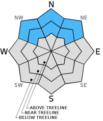
MODERATE avalanche danger continues near treeline and below treeline on NW-N-NE aspects on slopes 32 degrees and steeper due to ongoing instability of persistent slabs.

Human triggered avalanches remain possible. Pay attention to the big picture of surrounding terrain and the presence of steeper slopes above. Understand that remote triggering of avalanches from low angle slopes below to steeper slopes above is very possible under the current snowpack conditions.

1. Low

?

Above Treeline
Generally safe avalanche conditions. Watch for unstable snow on isolated terrain features.

2. Moderate

?

Near Treeline
Heightened avalanche conditions on specific terrain features. Evaluate snow and terrain carefully; identify features of concern.

2. Moderate

?

Below Treeline
Heightened avalanche conditions on specific terrain features. Evaluate snow and terrain carefully; identify features of concern.
    Heightened avalanche conditions on specific terrain features. Evaluate snow and terrain carefully; identify features of concern.
Avalanche Problem 1: Persistent Slab
  • Type ?
  • Aspect/Elevation ?
  • Likelihood ?
    Certain
    Very Likely
    Likely
    Possible
    Unlikely
  • Size ?
    Historic
    Very Large
    Large
    Small

It has now been a week since the last significant snowfall and it remains game on for avalanches. The areas with the deepest snowpack continue to hold the greatest amount of avalanche danger. Near treeline and below treeline slopes on NW-N-NE aspects that resisted scouring by the Nov 21-23 ENE gale force wind event hold significant amounts of faceted snow. This is the persistent weak layer below the overlying slab of recent storm snow from Dec 6-7.

Beware of steeper terrain above as remote triggering of avalanches from low angle terrain below is very possible under the current snowpack conditions.

recent observations

Persistent weak layers are the name of the game right now with little improvement in snowpack stability observed over the past week. Recent observations from around the forecast area continue to show the presence of the weak Dec 7 facet layer (sugary snow) in the bottom half of the snowpack on the vast majority of near treeline and below treeline NW-N-NE aspects. Where this was once several layers of crusts and facets, it is continuing to metamorphose into an increasingly homogenous facet layer as the crusts facet and erode. Human triggered snowpack collapse with whumphing sounds remains widespread in these areas along with unstable snowpit test results. Once collapse of the weak layer is triggered, propagation over distances of a few tens of feet to a few hundred feet have been observed.

Barely covered rocks, stumps, and/or logs that exist on most slopes present an additional hazard to backcountry travelers. There are very few areas where the shallow snowpack has enough structure or strength to keep a person from hitting these objects. The snow cover mostly serves to camouflage their presence.

Weather and CURRENT CONDITIONS
weather summary

High pressure is in place over the forecast area. Sunny skies are expected for the new few days. Air temperature inversion has temperatures in the low 20s to low 30s this morning over the higher terrain with single digits and teens on the mountain valley floors. Maximum daytime air temperatures are forecast to reach to mid 30s to low 40s today for areas above 7,000'. Moderate speed east winds will continue today before decreasing to light and variable for tonight and tomorrow.

CONDITIONS ALONG THE SIERRA CREST BETWEEN 8200 FT. AND 9200 FT. IN THE LAST 24 HOURS
6am temperature: 24 to 33 deg. F.
Max. temperature: 38 to 41 deg. F.
Average ridgetop wind direction: East
Average ridgetop wind speed: 25 mph
Maximum ridgetop wind gust: 42 mph
New snowfall: 0 inches
Total snow depth: 10 to 18 inches
Two-Day Mountain Weather Forecast Produced in partnership with the Reno NWS
For 7000 ft. to 8000 ft.
Saturday Saturday Night Sunday
Weather: Sunny skies. Clear skies. Sunny skies.
Temperatures: 36 to 43 deg. F. 20 to 28 deg. F. 41 to 48 deg. F.
Mid Slope Winds: SE Variable Variable
Wind Speed: 10 to 15 mph with gusts to 25 mph. Light winds. Light winds.
Expected snowfall: 0 0 0
For 8000 ft. to 9000 ft.
Saturday Saturday Night Sunday
Weather: Sunny skies. Clear skies. Sunny skies.
Temperatures: 36 to 43 deg. F. 21 to 28 deg. F. 41 to 48 deg. F.
Ridge Top Winds: East Variable Variable
Wind Speed: 15 to 25 mph with gusts to 40 mph. Light winds. Light winds.
Expected snowfall: 0 0 0
Disclaimer

This avalanche advisory is provided through a partnership between the Tahoe National Forest and the Sierra Avalanche Center. This advisory covers the Central Sierra Nevada Mountains between Yuba Pass on the north and Ebbetts Pass on the south. Click here for a map of the forecast area. This advisory applies only to backcountry areas outside established ski area boundaries. This advisory describes general avalanche conditions and local variations always occur. This advisory expires 24 hours after the posted time unless otherwise noted. The information in this advisory is provided by the USDA Forest Service who is solely responsible for its content.