THIS AVALANCHE FORECAST EXPIRED ON December 17, 2013 @ 6:59 am
Avalanche Forecast published on December 16, 2013 @ 6:59 am
Issued by Brandon Schwartz - Tahoe National Forest

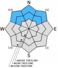
MODERATE avalanche danger continues near treeline and below treeline on NW-N-NE aspects on slopes 32 degrees and steeper due to ongoing persistent slab instability.

Current conditions are still very conducive to human triggered avalanches. Give this snowpack the respect it deserves. It is playing by its own set of rules.

1. Low

?

Above Treeline
Generally safe avalanche conditions. Watch for unstable snow on isolated terrain features.

2. Moderate

?

Near Treeline
Heightened avalanche conditions on specific terrain features. Evaluate snow and terrain carefully; identify features of concern.

2. Moderate

?

Below Treeline
Heightened avalanche conditions on specific terrain features. Evaluate snow and terrain carefully; identify features of concern.
    Heightened avalanche conditions on specific terrain features. Evaluate snow and terrain carefully; identify features of concern.
Avalanche Problem 1: Persistent Slab
  • Type ?
  • Aspect/Elevation ?
  • Likelihood ?
    Certain
    Very Likely
    Likely
    Possible
    Unlikely
  • Size ?
    Historic
    Very Large
    Large
    Small

Near treeline and below treeline slopes on NW-N-NE aspects that resisted scouring by the Nov 21-23 ENE gale force wind event hold significant amounts of faceted snow below the 9 day old storm snow. This is the Dec 7 persistent weak layer with an overlying slab. This weak layer is easily collapsed under the weight of a person and has shown the ability to propagate from tens of feet to hundreds of feet. Sizable human triggered avalanches are possible with triggering occurring either high on the slope, low on the slope, or remotely.

recent observations

Persistent instability is just that. Day after day field observations continue to show ongoing evidence of instability associated with the faceted Dec 7 persistent weak layer. Collapse and propagation continue to occur along this weak layer. Whumphing and cracking have been impressive at times, even in areas close to the tracks of previous backcountry travelers in the immediate area. See below for more detailed information on recent observations from Upper Ophir Creek (Mount Rose area) and from the Deep Creek drainage.

There are a few areas where the shallow snowpack has enough structure or strength to keep a person from hitting the many rocks and/or logs below. In other areas the snowpack remains unsupportable and impact with rocks and/or logs is inevitable.

Weather and CURRENT CONDITIONS
weather summary

High level cloud cover will give partly to mostly cloudy skies through Tuesday as high pressure dominates the weather pattern. Strong air temperature inversion remains in place with 30s and 40s above 6,500' and teens to 20s on the mountain valley floors this morning. Maximum daytime air temperatures are once again forecast to reach the upper 40s to mid 50s today for areas above 7,000'. Ridgetop winds are out of the east and increased to moderate in speed this morning. Winds are forecast to become light as the morning progresses. Moderate speed southwest winds are expected for late tonight and tomorrow.

CONDITIONS ALONG THE SIERRA CREST BETWEEN 8200 FT. AND 9200 FT. IN THE LAST 24 HOURS
6am temperature: 35 to 46 deg. F.
Max. temperature: 54 to 58 deg. F.
Average ridgetop wind direction: East
Average ridgetop wind speed: 15 mph
Maximum ridgetop wind gust: 35 mph
New snowfall: 0 inches
Total snow depth: 8 to 17 inches
Two-Day Mountain Weather Forecast Produced in partnership with the Reno NWS
For 7000 ft. to 8000 ft.
Monday Monday Night Tuesday
Weather: Partly cloudy skies. Partly cloudy skies. Mostly cloudy skies.
Temperatures: 49 to 55 deg. F. 25 to 35 deg. F. 46 to 53 deg. F.
Mid Slope Winds: Variable Becoming SW after midnight. SW
Wind Speed: Light winds. Light winds increasing to 10 to 15 mph after midnight. 10 to 15 mph with gusts to 25 mph.
Expected snowfall: 0 0 0
For 8000 ft. to 9000 ft.
Monday Monday Night Tuesday
Weather: Partly cloudy skies. Partly cloudy skies. Mostly cloudy skies.
Temperatures: 47 to 54 deg. F. 35 to 43 deg. F. 46 to 53 deg. F.
Ridge Top Winds: Variable SW SW
Wind Speed: Light winds 15 to 20 mph. Gusts to 35 mph after midnight. 15 to 25 mph with gusts to 40 mph.
Expected snowfall: 0 0 0
Disclaimer

This avalanche advisory is provided through a partnership between the Tahoe National Forest and the Sierra Avalanche Center. This advisory covers the Central Sierra Nevada Mountains between Yuba Pass on the north and Ebbetts Pass on the south. Click here for a map of the forecast area. This advisory applies only to backcountry areas outside established ski area boundaries. This advisory describes general avalanche conditions and local variations always occur. This advisory expires 24 hours after the posted time unless otherwise noted. The information in this advisory is provided by the USDA Forest Service who is solely responsible for its content.