THIS AVALANCHE FORECAST EXPIRED ON December 18, 2013 @ 6:30 am
Avalanche Forecast published on December 17, 2013 @ 6:30 am
Issued by Brandon Schwartz - Tahoe National Forest

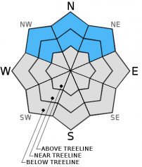
Avalanche danger remains MODERATE near treeline and below treeline on NW-N-NE aspects on slopes 32 degrees and steeper due to ongoing persistent slab instability.

Current conditions remain conducive to human triggered avalanches.

1. Low

?

Above Treeline
Generally safe avalanche conditions. Watch for unstable snow on isolated terrain features.

2. Moderate

?

Near Treeline
Heightened avalanche conditions on specific terrain features. Evaluate snow and terrain carefully; identify features of concern.

2. Moderate

?

Below Treeline
Heightened avalanche conditions on specific terrain features. Evaluate snow and terrain carefully; identify features of concern.
    Heightened avalanche conditions on specific terrain features. Evaluate snow and terrain carefully; identify features of concern.
Avalanche Problem 1: Persistent Slab
  • Type ?
  • Aspect/Elevation ?
  • Likelihood ?
    Certain
    Very Likely
    Likely
    Possible
    Unlikely
  • Size ?
    Historic
    Very Large
    Large
    Small

Near treeline and below treeline slopes on NW-N-NE aspects continue to present a risk for human triggered avalanches. Slopes that resisted scouring by the Nov 21-23 ENE gale force wind event hold significant amounts of faceted snow below the upper layers of 10 day old storm snow. This is the Dec 7 persistent weak layer with its overlying slab. This weak layer can collapsed under the weight of a person and has shown the ability to propagate from tens of feet to hundreds of feet. Under the current conditions, it is possible to trigger an avalanche either high on the slope, low on the slope, or remotely.

recent observations

Various locations around the forecast area are starting to show variability in the amount of instability associated with the faceted Dec 7 persistent weak layer. In some areas, obvious signs of instability continue to present with impressive amounts of whumphing and cracking occurring on a regular basis. In other areas, the triggering of snowpack collapse, shooting cracks, and other obvious signs of instability are becoming less frequent. In these areas evidence of instability is still very apparent in snowpit tests. Take steps to constantly mitigate hazard. Don't get caught by surprise.

See below for more detailed information on recent observations from Becker Ridge (Echo Summit area), Upper Ophir Creek (Mount Rose area), and from the Deep Creek drainage.

Weather and CURRENT CONDITIONS
weather summary

One more day of high pressure and strong air temperature inversion is expected before a weak low pressure system moves into the forecast area. There is a chance of light snowfall Wednesday night and Thursday. High level could cover will further increase today ahead of the approaching weather system. Ridgetop winds shifted to the southwest overnight and are moderate in speed. Southwest winds are forecast to continue for the next few days, mixing out the air temperature inversion.

CONDITIONS ALONG THE SIERRA CREST BETWEEN 8200 FT. AND 9200 FT. IN THE LAST 24 HOURS
6am temperature: 37 to 49 deg. F.
Max. temperature: 50 to 58 deg. F.
Average ridgetop wind direction: East shifting to Southwest
Average ridgetop wind speed: 20 mph
Maximum ridgetop wind gust: 36 mph
New snowfall: 0 inches
Total snow depth: 8 to 17 inches
Two-Day Mountain Weather Forecast Produced in partnership with the Reno NWS
For 7000 ft. to 8000 ft.
Tuesday Tuesday Night Wednesday
Weather: High level cloud cover creating mostly cloudy skies. Mostly cloudy skies, becoming partly cloudy. Mostly cloudy skies.
Temperatures: 51 to 57 deg. F. 26 to 34 deg. F. 38 to 45 deg. F.
Mid Slope Winds: SW SW SW
Wind Speed: 10 to 15 mph. 10 to 15 mph. 10 to 20 mph with gusts to 30 mph.
Expected snowfall: 0 0 0
For 8000 ft. to 9000 ft.
Tuesday Tuesday Night Wednesday
Weather: High level cloud cover creating mostly cloudy skies. Mostly cloudy skies, becoming partly cloudy. Mostly cloudy skies.
Temperatures: 46 to 53 deg. F. 31 to 37 deg. F. 39 to 45 deg. F.
Ridge Top Winds: SW SW SW
Wind Speed: 20 to 25 mph with gusts to 35 mph, decreasing to 10 to 15 mph with gusts to 25 mph in the afternoon. 15 to 20 mph with gusts to 30 mph. 15 to 20 mph with gusts to 35 mph, increasing to 25 to 30 mph with gusts to 45 mph in the afternoon.
Expected snowfall: 0 0 0
Disclaimer

This avalanche advisory is provided through a partnership between the Tahoe National Forest and the Sierra Avalanche Center. This advisory covers the Central Sierra Nevada Mountains between Yuba Pass on the north and Ebbetts Pass on the south. Click here for a map of the forecast area. This advisory applies only to backcountry areas outside established ski area boundaries. This advisory describes general avalanche conditions and local variations always occur. This advisory expires 24 hours after the posted time unless otherwise noted. The information in this advisory is provided by the USDA Forest Service who is solely responsible for its content.