


For 7000 ft. to 8000 ft.
| Thursday | Thursday Night | Friday | |
|---|---|---|---|
| Weather: | Snow in the morning. Snow showers tapering off in the afternoon. | Partly cloudy with a few scattered snow showers. | Sunny in the morning with some clouds developing in the afternoon. |
| Temperatures: | 18-25 deg. F. | 11-17 deg. F. | 30-37 deg. F. |
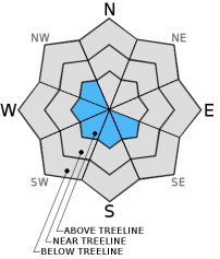
| Mid Slope Winds: | NE | NE | NE |
| Wind Speed: | 20-30 mph with gusts to 40 mph | 20-30 mph with gusts to 40 mph | 15-25 mph with gusts to 40 mph |
| Expected snowfall: | 2-4 | 0 | 0 |
For 8000 ft. to 9000 ft.
| Thursday | Thursday Night | Friday | |
|---|---|---|---|
| Weather: | Snow in the morning. Snow showers tapering off in the afternoon. | Partly cloudy with a few scattered snow showers. | Sunny in the morning with some clouds developing in the afternoon. |
| Temperatures: | 18-24 deg. F. | 9-16 deg. F. | 29-36 deg. F. |
| Ridge Top Winds: | N shifting to the NE | NE | NE |
| Wind Speed: | 20-25 mph with gusts to 40 mph increasing to 35-40 mph with gusts to 60 mph | 45-50 mph with gusts to 70 mph | 35-40 mph with gusts to 60 mph |
| Expected snowfall: | 2-4 | 0 | 0 |


