THIS AVALANCHE FORECAST EXPIRED ON December 21, 2013 @ 6:35 am
Avalanche Forecast published on December 20, 2013 @ 6:35 am
Issued by Andy Anderson - Tahoe National Forest - Sierra Avalanche Center

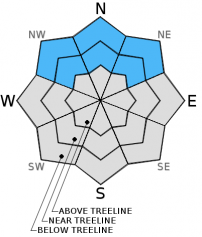
MODERATE avalanche danger will continue on the near and below treeline NW-N-NE aspects on slopes 32 degrees and steeper due to lingering persistent slabs.

Human triggered avalanches remain possible. Due to the shallow snowpack any avalanches that do occur would drag people through and into obstacles like rocks, stumps, and other hard immobile obstacles.

1. Low

?

Above Treeline
Generally safe avalanche conditions. Watch for unstable snow on isolated terrain features.

2. Moderate

?

Near Treeline
Heightened avalanche conditions on specific terrain features. Evaluate snow and terrain carefully; identify features of concern.

2. Moderate

?

Below Treeline
Heightened avalanche conditions on specific terrain features. Evaluate snow and terrain carefully; identify features of concern.
    Heightened avalanche conditions on specific terrain features. Evaluate snow and terrain carefully; identify features of concern.
Avalanche Problem 1: Persistent Slab
  • Type ?
  • Aspect/Elevation ?
  • Likelihood ?
    Certain
    Very Likely
    Likely
    Possible
    Unlikely
  • Size ?
    Historic
    Very Large
    Large
    Small

Persistent slabs remain widespread on the near and below treeline NW-N-NE aspects. The Dec. 7th facets represent the persistent weak layer. The layer of cohesive snow above them represents the slab layer. This combination remains unstable on the edge of failure waiting for some kind of trigger to break it. Human triggered avalanche activity remains possible on these slopes. People can trigger these kind of persistent slabs remotely while standing in low angle terrain or on ridgelines or anywhere that the snowpack under their feet connects to steeper and/or deeper terrain because fractures can travel through the persistent weak layer. 

Any of these avalanches that do occur would drag a person through rocks, stumps, trees, and other obstacles because of the shallow snowpack and the fact that the near and below treeline terrain holds the most unstable snow as well as the greatest number of obstacles.

recent observations

Yesterday observations in Deep Creek (video, photo, snowpit) and in the Wild Card (more info) area (Mt. Rose backcountry) showed a snowpack structure with a layer of well-consolidated snow sitting above a layer of weak sugary snow (Dec. 7th facets). In both of these areas snowpit data and tests indicated that the snowpack remains weak and that if it does break, the resulting fracture can travel along the persistent weak layer. In the Deep Creek area observations showed small improvements in the snowpack since 12/14 and no human triggered collapsing or whumpfing occurred. On the other hand, the additional weight of people on the snowpack in the Wildcard area triggered large whumpfs and collapses.

The meager amount of new snow that fell yesterday did little to change the state of the snowpack. No new wind slabs formed in either of these areas yesterday due to the lack of new snow combined with the fact that the strong winds remained limited to ridge crests above treeline.

Barely covered rocks, stumps, logs, and other hard, immobile, season-ending, equipment-breaking objects still exist on all slopes. The shallow snowpack does not have enough structure or strength to keep a person above all these things. It only camouflages their existence.

Weather and CURRENT CONDITIONS
weather summary

1-2 inches of snow accumulated during yesterday's storm. Snowfall quickly tapered off leaving behind cold temperatures and light winds near and below treeline. Along top of the Sierra Crest Ridgeline, strong ENE winds prevailed. A high pressure has moved in behind this system bringing more dry, mostly clear, and warmer weather to the region. Today's highs should climb into the low to mid 30's above 7000 ft, and tomorrow's could reach into the mid to upper 30's. A small system passing to the north of the forecast area could push some cloud cover over the Tahoe region this afternoon and tonight, but that should remain short-lived and clear back up tomorrow. The forecast calls for the NE winds to remain strong above treeline today and tomorrow, while winds at the lower elevations should be much weaker.

CONDITIONS ALONG THE SIERRA CREST BETWEEN 8200 FT. AND 9200 FT. IN THE LAST 24 HOURS
6am temperature: 11 to 22 deg. F.
Max. temperature: 19 to 26 deg. F.
Average ridgetop wind direction: ENE
Average ridgetop wind speed: Along the Crest: 30-40 mph | Below the Crest: 10-20 mph
Maximum ridgetop wind gust: 55 mph
New snowfall: 1 to 2 inches
Total snow depth: 10 to 19 inches
Two-Day Mountain Weather Forecast Produced in partnership with the Reno NWS
For 7000 ft. to 8000 ft.
Friday Friday Night Saturday
Weather: Sunny with some cloud cover moving in this afternoon Mostly cloudy becoming partly cloudy Partly cloudy in the morning becoming sunny
Temperatures: 31-37 deg. F. 22-30 deg. F. 34-40 deg. F.
Mid Slope Winds: NE N N shifting to the NE
Wind Speed: 20-35 mph with gusts to 50 mph 25-35 mph with gusts to 50 mph 35-40 mph with gusts to 60 mph decreasing to 25-35 mph with gusts to 50 mph in the afternoon
Expected snowfall: 0 0 0
For 8000 ft. to 9000 ft.
Friday Friday Night Saturday
Weather: Sunny with some cloud cover moving in this afternoon Mostly cloudy becoming partly cloudy Partly cloudy in the morning becoming sunny
Temperatures: 28-35 deg. F. 21-26 deg. F. 32-38 deg. F.
Ridge Top Winds: NE N N
Wind Speed: 40-50 mph with gusts to 65 mph 45-55 mph with gusts to 70 mph 45-55 mph with gusts to 75 mph decreasing to 35-45 mph with gusts to 60 mph in the afternoon
Expected snowfall: 0 0 0
Disclaimer

This avalanche advisory is provided through a partnership between the Tahoe National Forest and the Sierra Avalanche Center. This advisory covers the Central Sierra Nevada Mountains between Yuba Pass on the north and Ebbetts Pass on the south. Click here for a map of the forecast area. This advisory applies only to backcountry areas outside established ski area boundaries. This advisory describes general avalanche conditions and local variations always occur. This advisory expires 24 hours after the posted time unless otherwise noted. The information in this advisory is provided by the USDA Forest Service who is solely responsible for its content.