THIS AVALANCHE FORECAST EXPIRED ON December 22, 2013 @ 6:49 am
Avalanche Forecast published on December 21, 2013 @ 6:49 am
Issued by Brandon Schwartz - Tahoe National Forest

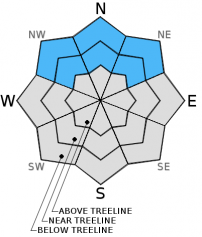
Near treeline and below treeline, MODERATE avalanche danger continues on NW-N-NE aspects on slopes 32 degrees and steeper due to lingering persistent slabs.

Human triggered avalanches remain possible. Shallow covered rocks, logs, and stumps are an additional hazard to backcountry travelers. Impact with rocks or trees while caught in an avalanche can greatly increase consequences.

1. Low

?

Above Treeline
Generally safe avalanche conditions. Watch for unstable snow on isolated terrain features.

2. Moderate

?

Near Treeline
Heightened avalanche conditions on specific terrain features. Evaluate snow and terrain carefully; identify features of concern.

2. Moderate

?

Below Treeline
Heightened avalanche conditions on specific terrain features. Evaluate snow and terrain carefully; identify features of concern.
    Heightened avalanche conditions on specific terrain features. Evaluate snow and terrain carefully; identify features of concern.
Avalanche Problem 1: Persistent Slab
  • Type ?
  • Aspect/Elevation ?
  • Likelihood ?
    Certain
    Very Likely
    Likely
    Possible
    Unlikely
  • Size ?
    Historic
    Very Large
    Large
    Small

It is now two weeks past the most recent significant snowfall event and persistent slab instability continues. While some small and very gradual improvement in stability has occurred over that time, it is fairly negligible in the big picture. The problematic Dec 7 persistent weak layer remains widespread in NE wind protected areas near treeline and below treeline on NW-N-NE aspects. Obvious clues of instability are still encountered on a near daily basis by backcountry travelers. Snowpit data remains very telling of the current instability. Venturing into steep terrain where this weak layer exists beneath an overlying slab is begging to trigger an avalanche.

recent observations

Observations made yesterday on the East Ridge of Tamarack Peak (Mount Rose backcountry) fell right in line with previous observations made around the forecast area over the past two weeks. Persistent slab instability continues near treeline and below treeline on NW-N-NE aspects. In these areas, the faceted Dec 7 persistent weak layer is barely able to support the overlying slab of cohesive snow. Once the additional weight of a person is added to the snowpack, collapse of the weak layer has frequently occurred. This is clearly seen in snowpit tests on a regular basis, in addition to the human triggered collapsing, whumphing, and cracking that is still experienced in some areas. Yesterday's NE ridgetop winds were once again observed to scour snow from above treeline areas on N-NE aspects.

Rocks, logs, and stumps lurk below the snow surface. The ability of the snowpack to keep a person supported above these hazards remains variable and can change greatly over short distances. Travel accordingly to minimize the risk of injury.

Weather and CURRENT CONDITIONS
weather summary

High pressure will build over the forecast area this afternoon and tonight. Lingering cloud cover this morning is expected to clear this afternoon, bringing the eventual return of sunny skies. Maximum daytime air temperatures are forecast in the 30s today for areas above 7,000'. Ridgetop winds for today and tomorrow will remain out of the north to northeast. Winds speeds are forecast to remain strong today, gradually decreasing in speed tomorrow.

CONDITIONS ALONG THE SIERRA CREST BETWEEN 8200 FT. AND 9200 FT. IN THE LAST 24 HOURS
6am temperature: 27 to 30 deg. F.
Max. temperature: 31 to 36 deg. F.
Average ridgetop wind direction: NE
Average ridgetop wind speed: 21 mph
Maximum ridgetop wind gust: 53 mph
New snowfall: 0 inches
Total snow depth: 10 to 19 inches
Two-Day Mountain Weather Forecast Produced in partnership with the Reno NWS
For 7000 ft. to 8000 ft.
Saturday Saturday Night Sunday
Weather: Mostly cloudy skies, becoming partly cloudy. Clear skies. Sunny skies.
Temperatures: 31 to 37 deg. F. 21 to 29 deg. F. 32 to 45 deg. F.
Mid Slope Winds: N NE NE
Wind Speed: 25 to 35 mph with gusts to 50 mph. 20 to 30 mph with gusts to 45 mph. 25 to 30 mph with gusts to 40 mph, decreasing to 10 to 15 mph with gusts to 25 mph in the afternoon.
Expected snowfall: 0 0 0
For 8000 ft. to 9000 ft.
Saturday Saturday Night Sunday
Weather: Mostly cloudy skies, becoming partly cloudy. Clear skies. Sunny skies.
Temperatures: 30 to 36 deg. F. 20 to 28 deg. F. 32 to 39 deg. F.
Ridge Top Winds: N NE NE
Wind Speed: 35 to 45 mph with gusts to 60 mph. 30 to 40 mph with gusts to 55 mph. 30 to 35 mph with gusts to 50 mph, decreasing to 20 to 25 mph with gusts to 35 mph in the afternoon.
Expected snowfall: 0 0 0
Disclaimer

This avalanche advisory is provided through a partnership between the Tahoe National Forest and the Sierra Avalanche Center. This advisory covers the Central Sierra Nevada Mountains between Yuba Pass on the north and Ebbetts Pass on the south. Click here for a map of the forecast area. This advisory applies only to backcountry areas outside established ski area boundaries. This advisory describes general avalanche conditions and local variations always occur. This advisory expires 24 hours after the posted time unless otherwise noted. The information in this advisory is provided by the USDA Forest Service who is solely responsible for its content.