


For 7000 ft. to 8000 ft.
| Sunday | Sunday Night | Monday | |
|---|---|---|---|
| Weather: | Partly cloudy skies, becoming sunny. | Clear skies. | Sunny skies. |
| Temperatures: | 37 to 44 deg. F. | 23 to 31 deg. F. | 42 to 49 deg. F. |
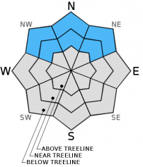
| Mid Slope Winds: | NE | E | Variable |
| Wind Speed: | 20 to 25 mph with gusts to 35 mph, decreasing to 10 to 15 mph with gusts to 25 mph in the afternoon. | 10 to 15 mph. | Light winds. |
| Expected snowfall: | 0 | 0 | 0 |
For 8000 ft. to 9000 ft.
| Sunday | Sunday Night | Monday | |
|---|---|---|---|
| Weather: | Partly cloudy skies, becoming sunny. | Clear skies. | Sunny skies. |
| Temperatures: | 35 to 42 deg. F. | 23 to 30 deg. F. | 40 to 47 deg. F. |
| Ridge Top Winds: | NE | NE | W |
| Wind Speed: | 20 to 30 mph with gusts to 40 mph. | 15 to 20 mph with gusts to 30 mph. | 10 to 15 mph. Gusts to 25 mph in the afternoon. |
| Expected snowfall: | 0 | 0 | 0 |


