THIS AVALANCHE FORECAST EXPIRED ON December 24, 2013 @ 6:38 am
Avalanche Forecast published on December 23, 2013 @ 6:38 am
Issued by Brandon Schwartz - Tahoe National Forest

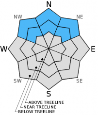
Near treeline and below treeline, MODERATE avalanche danger continues on NW-N-NE aspects on slopes 32 degrees and steeper due to lingering persistent slabs.

Human triggered avalanches remain possible. Shallow covered rocks, logs, and stumps are an additional hazard to backcountry travelers. Impact with rocks or trees while caught in an avalanche can greatly increase consequences.

1. Low

?

Above Treeline
Generally safe avalanche conditions. Watch for unstable snow on isolated terrain features.

2. Moderate

?

Near Treeline
Heightened avalanche conditions on specific terrain features. Evaluate snow and terrain carefully; identify features of concern.

2. Moderate

?

Below Treeline
Heightened avalanche conditions on specific terrain features. Evaluate snow and terrain carefully; identify features of concern.
    Heightened avalanche conditions on specific terrain features. Evaluate snow and terrain carefully; identify features of concern.
Avalanche Problem 1: Persistent Slab
  • Type ?
  • Aspect/Elevation ?
  • Likelihood ?
    Certain
    Very Likely
    Likely
    Possible
    Unlikely
  • Size ?
    Historic
    Very Large
    Large
    Small

Just over two weeks have past since the most recent significant snowfall event, and persistent slab instability continues. While some small and very gradual improvement in stability has occurred over that time, it does not negate the fact that human triggered avalanches remain possible. The problematic faceted Dec 7 persistent weak layer remains widespread on NE wind protected slopes near treeline and below treeline on NW-N-NE aspects. Evidence of instability is still encountered on a near daily basis by backcountry travelers. Snowpit data continues to point out the current instability. Avalanche avoidance through travel on sub 32 degree slopes without steeper slopes above remains the best way to mitigate the hazard.

recent observations

Observations made yesterday on Andesite Ridge (Donner Summit area) and near Grouse Rocks (Ward Canyon area) matched well with other previous observations from around the forecast area near treeline and below treeline on NW-N-NE aspects. Snowpit data in both locations indicated that the faceted Dec 7 persistent weak layer has become more difficult to collapse, but still shows the ability to propagate. Other recent observations from around the forecast area have also shown some stability improvements and increased difficulty in triggering weak layer collapse. The ongoing propagation potential remains problematic, as it has been observed in snowpit data on slopes with and without ski tracks. This indicates that if the right trigger point is found on the slope, the necessary snowpack ingredients for a human triggered avalanche remain present.

Rocks, logs, and stumps lurk below the snow surface. The ability of the snowpack to keep a person supported above these hazards remains variable and can change greatly over short distances. Travel accordingly to minimize the risk of injury. 

Weather and CURRENT CONDITIONS
weather summary

High pressure parked just off shore will bring sunny skies with occasional clouds to the region as weather systems pass to the north of the forecast area. Weak air temperature inversion has below freezing temperatures on the mountain valley floors with air temperatures generally in the mid to upper 30's at 8,000 ft. Ridgetop winds have shifted from east to west overnight. Light to moderate speed winds are forecast for today.

CONDITIONS ALONG THE SIERRA CREST BETWEEN 8200 FT. AND 9200 FT. IN THE LAST 24 HOURS
6am temperature: 30 to 40 deg. F.
Max. temperature: 39 to 42 deg. F.
Average ridgetop wind direction: E shifing to W
Average ridgetop wind speed: 30 mph
Maximum ridgetop wind gust: 51 mph
New snowfall: 0 inches
Total snow depth: 10 to 19 inches
Two-Day Mountain Weather Forecast Produced in partnership with the Reno NWS
For 7000 ft. to 8000 ft.
Monday Monday Night Tuesday
Weather: Sunny skies becoming partly cloudy. Partly cloudy. Partly cloudy skies becoming sunny.
Temperatures: 42 to 49 deg. F. 25 to 33 deg. F. 41 to 48 deg. F.
Mid Slope Winds: SW W variable
Wind Speed: 10 to 15 mph 10 to 15 mph in the evening becoming light. Light winds.
Expected snowfall: 0 0 0
For 8000 ft. to 9000 ft.
Monday Monday Night Tuesday
Weather: Sunny skies becoming partly cloudy. Partly cloudy skies. Partly cloudy skies becoming sunny.
Temperatures: 40 to 47 deg. F. 28 to 34 deg. F. 40 to 47 deg. F.
Ridge Top Winds: NW W W shifting to S.
Wind Speed: 15 to 20 mph 20 to 25 mph decreasing to 10 to 15 mph after midnight. 10 to 15 mph with gusts to 25 mph.
Expected snowfall: 0 0 0
Disclaimer

This avalanche advisory is provided through a partnership between the Tahoe National Forest and the Sierra Avalanche Center. This advisory covers the Central Sierra Nevada Mountains between Yuba Pass on the north and Ebbetts Pass on the south. Click here for a map of the forecast area. This advisory applies only to backcountry areas outside established ski area boundaries. This advisory describes general avalanche conditions and local variations always occur. This advisory expires 24 hours after the posted time unless otherwise noted. The information in this advisory is provided by the USDA Forest Service who is solely responsible for its content.