THIS AVALANCHE FORECAST EXPIRED ON December 26, 2013 @ 7:01 am
Avalanche Forecast published on December 24, 2013 @ 7:01 am
Issued by Andy Anderson - Tahoe National Forest - Sierra Avalanche Center

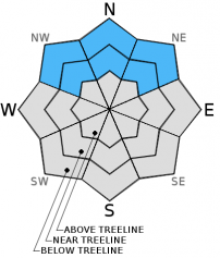
MODERATE avalanche danger still lingers on near and below treeline NW-N-NE aspects on slopes steeper than 32 degrees because persistent slabs still remain in those areas.

Human triggered avalanches remain possible. Barely covered rocks, logs, stumps and other obstacles would increase the consequences of any avalanches that do occur.

I will update the advisory again on Dec. 26 at 7:00 am.

1. Low

?

Above Treeline
Generally safe avalanche conditions. Watch for unstable snow on isolated terrain features.

2. Moderate

?

Near Treeline
Heightened avalanche conditions on specific terrain features. Evaluate snow and terrain carefully; identify features of concern.

2. Moderate

?

Below Treeline
Heightened avalanche conditions on specific terrain features. Evaluate snow and terrain carefully; identify features of concern.
    Heightened avalanche conditions on specific terrain features. Evaluate snow and terrain carefully; identify features of concern.
Avalanche Problem 1: Persistent Slab
  • Type ?
  • Aspect/Elevation ?
  • Likelihood ?
    Certain
    Very Likely
    Likely
    Possible
    Unlikely
  • Size ?
    Historic
    Very Large
    Large
    Small

Persistent slabs still exist on NW-N-NE aspects in near and below treeline terrain. In some areas the myriad of anchors/obstacles poking through the snowpack have kept these slabs small. In some areas these slabs have become more difficult to trigger. However, in most places data and observations continue to indicate that the additional weight of a person on top of the slope can break the weak layer (Dec 7th facets) and that the resulting fracture can still travel along that weak layer. Human triggered persistent slabs avalanches remain possible. 

Any of these avalanches that do occur would drag a person through rocks, stumps, trees, and other obstacles because of the shallow snowpack and the fact that the near and below treeline terrain holds the most unstable snow as well as the greatest number of obstacles.

recent observations

Yesterday, observations along Becker Ridge showed some signs of improving stability (snowpit, more info). The Dec 7th facets still exist in this area and a more cohesive slab layer still sits above them. Snowpit data and tests still indicated that the sugary snow comprising the Dec 7th facets remains weak and easy to break, but that the resulting fractures did not travel very far along the weak layer. Also no human-triggered whumphing, collapsing, or cracking occurred. In contrast to this more benign data, the majority of data from around the region still points to an unstable snowpack in which fractures can easily travel along the Dec 7th facet layer (see the observations page).

As persistent weak layers like this one gain strength, they strengthen sporadically with some areas showing no signs of instability while adjacent areas remain unstable and easy to trigger. This process leads to a great deal of variability on all scales and uncertainty about which slopes or even which parts of the same slope remain unstable. Recent observations seem to indicate some of this variability.

The weak and shallow snowpack will not support a person or snowmobile enough to prevent collisions with all of the barely covered rocks, stumps, logs, and other hard immobile objects. Collisions with these obstacles could easily break equipment and injure people.  

Weather and CURRENT CONDITIONS
weather summary

High pressure over the region will cause the clear, dry and warmer than normal weather to continue through the week. Expect daytime highs in the mid to upper 40's for the next several days above 7000 ft. The winds should also remain light. Cooler air should remained trapped in the valleys creating inversion conditions where the valleys remain colder than the mountains.

CONDITIONS ALONG THE SIERRA CREST BETWEEN 8200 FT. AND 9200 FT. IN THE LAST 24 HOURS
6am temperature: 32 to 34 deg. F.
Max. temperature: 45 to 48 deg. F.
Average ridgetop wind direction: NE
Average ridgetop wind speed: 5 to 10 mph
Maximum ridgetop wind gust: 25 mph
New snowfall: 0 inches
Total snow depth: 9 to 18 inches
Two-Day Mountain Weather Forecast Produced in partnership with the Reno NWS
For 7000 ft. to 8000 ft.
Tuesday Tuesday Night Wednesday
Weather: Partly cloudy becoming sunny Clear Sunny
Temperatures: 41 to 48 deg. F. 23 to 31 deg. F. 41 to 48 deg. F.
Mid Slope Winds: Variable Variable Variable
Wind Speed: Light Light Light
Expected snowfall: 0 0 0
For 8000 ft. to 9000 ft.
Tuesday Tuesday Night Wednesday
Weather: Partly cloudy becoming sunny Clear Sunny
Temperatures: 40 to 47 deg. F. 28 to 34 deg. F. 40 to 47 deg. F.
Ridge Top Winds: East East Variable
Wind Speed: 10-15 mph 10-15 mph decreasing overnight Light
Expected snowfall: 0 0 0
Disclaimer

This avalanche advisory is provided through a partnership between the Tahoe National Forest and the Sierra Avalanche Center. This advisory covers the Central Sierra Nevada Mountains between Yuba Pass on the north and Ebbetts Pass on the south. Click here for a map of the forecast area. This advisory applies only to backcountry areas outside established ski area boundaries. This advisory describes general avalanche conditions and local variations always occur. This advisory expires 24 hours after the posted time unless otherwise noted. The information in this advisory is provided by the USDA Forest Service who is solely responsible for its content.