THIS AVALANCHE FORECAST EXPIRED ON December 29, 2013 @ 6:56 am
Avalanche Forecast published on December 28, 2013 @ 6:56 am
Issued by Brandon Schwartz - Tahoe National Forest

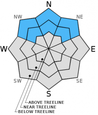
Avalanche danger remains MODERATE near treeline and below treeline on NW-N-NE aspects on slopes steeper than 32 degrees due to lingering persistent slab instability.

Signs of snowpack instability are still observed on a near daily basis. Human triggered avalanches are possible. 

1. Low

?

Above Treeline
Generally safe avalanche conditions. Watch for unstable snow on isolated terrain features.

2. Moderate

?

Near Treeline
Heightened avalanche conditions on specific terrain features. Evaluate snow and terrain carefully; identify features of concern.

2. Moderate

?

Below Treeline
Heightened avalanche conditions on specific terrain features. Evaluate snow and terrain carefully; identify features of concern.
    Heightened avalanche conditions on specific terrain features. Evaluate snow and terrain carefully; identify features of concern.
Avalanche Problem 1: Persistent Slab
  • Type ?
  • Aspect/Elevation ?
  • Likelihood ?
    Certain
    Very Likely
    Likely
    Possible
    Unlikely
  • Size ?
    Historic
    Very Large
    Large
    Small

Persistent slab instability remains ongoing near treeline and below treeline on NW-N-NE aspects. The faceted Dec 7 persistent weak layer is slowly gaining strength, but not enough to make much difference in terms of reducing overall avalanche danger.

Knowing that the ongoing going avalanche problem is a persistent slab issue, finding a lack of evidence of instability while moving around the backcountry should be cause for concern. Anyone finding themselves in that position and desiring to commit to NW-N-NE aspects on slopes steeper than 32 degrees is advised to spend additional time assessing snowpack stability on a slope by slope basis in order to find the missing pieces of data.

recent observations

It has been three weeks since the last significant snowfall and obvious clues of instability are still apparent. Yesterday on Silver Peak (Pole Creek area), travel on slopes that had not experienced traffic since the Dec 7 snowfall event caused localized cracking and skier triggered collapsing to occur. One of the collapses radiated out approximately 60 feet from the trigger point. This matched well with much of the other recent snowpit data from around the forecast area that has repeatedly shown that the faceted Dec 7 persistent weak layer retains the ability to propagate fractures once collapsed.

Spacial variability is increasing around the forecast area in regards to stability improvements of the Dec 7 faceted weak layer. The amount of force required to trigger weak layer collapse and the ability for that collapse to propagate are becoming more variable from one location to another. In some spots, strength increases in the Dec 7 persistent weak layer are highly evident while in other areas the strength gains have been much more modest. Either way, the data still indicates that human triggered avalanches are possible in many locations around the forecast area.

Weather and CURRENT CONDITIONS
weather summary

A weak and dry cold front will pass through the region today. Ridgetop winds are forecast to shift from the southwest to east and north following frontal passage around mid day. The associated winds will finally mix out the air temperature inversion that has persisted over the area, at least for the short term. Moderate speed ridgetop winds are expected to continue through the weekend. Maximum daytime air temperatures will be a bit cooler today at the mid and upper elevations before warming again on Sunday.

2013 is expected to finish as the driest year on record for Tahoe City, CA (click here for more info from the NWS on this record).

CONDITIONS ALONG THE SIERRA CREST BETWEEN 8200 FT. AND 9200 FT. IN THE LAST 24 HOURS
6am temperature: 28 to 35 deg. F.
Max. temperature: 43 to 48 deg. F.
Average ridgetop wind direction: SW
Average ridgetop wind speed: 19 mph
Maximum ridgetop wind gust: 36 mph
New snowfall: 0 inches
Total snow depth: 8 to 16 inches
Two-Day Mountain Weather Forecast Produced in partnership with the Reno NWS
For 7000 ft. to 8000 ft.
Saturday Saturday Night Sunday
Weather: Sunny skies. Clear skies. Sunny skies.
Temperatures: 38 to 45 deg. F. 25 to 30 deg. F. 40 to 47 deg. F.
Mid Slope Winds: West shifting to East East Northeast
Wind Speed: 10 to 15 mph with gusts to 30 mph, shifting and increasing to 20 to 25 mph with gusts to 40 mph in the afternoon. 15 to 25 mph. Gusts to 45 mph, decreasing to 35 mph after midnight. 15 to 20 mph with gusts to 30 mph.
Expected snowfall: 0 0 0
For 8000 ft. to 9000 ft.
Saturday Saturday Night Sunday
Weather: Sunny skies. Clear skies. Sunny skies.
Temperatures: 35 to 40 deg. F. 23 to 30 deg. F. 40 to 47 deg. F.
Ridge Top Winds: West shifting to East. East Northeast
Wind Speed: 20 to 25 mph. Gusts up to 45 mph. 20 to 30 mph with gusts to 55 mph. 20 to 30 mph with gusts to 45 mph.
Expected snowfall: 0 0 0
Disclaimer

This avalanche advisory is provided through a partnership between the Tahoe National Forest and the Sierra Avalanche Center. This advisory covers the Central Sierra Nevada Mountains between Yuba Pass on the north and Ebbetts Pass on the south. Click here for a map of the forecast area. This advisory applies only to backcountry areas outside established ski area boundaries. This advisory describes general avalanche conditions and local variations always occur. This advisory expires 24 hours after the posted time unless otherwise noted. The information in this advisory is provided by the USDA Forest Service who is solely responsible for its content.