THIS AVALANCHE FORECAST EXPIRED ON December 30, 2013 @ 6:40 am
Avalanche Forecast published on December 29, 2013 @ 6:40 am
Issued by Brandon Schwartz - Tahoe National Forest

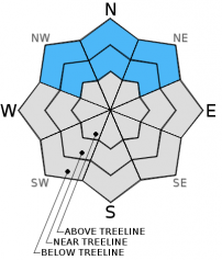
Avalanche danger remains MODERATE near treeline and below treeline on NW-N-NE aspects on slopes steeper than 32 degrees due to lingering persistent slab instability.

Ongoing signs of snowpack instability have been observed on a regular basis. Human triggered avalanches remain possible. 

1. Low

?

Above Treeline
Generally safe avalanche conditions. Watch for unstable snow on isolated terrain features.

2. Moderate

?

Near Treeline
Heightened avalanche conditions on specific terrain features. Evaluate snow and terrain carefully; identify features of concern.

2. Moderate

?

Below Treeline
Heightened avalanche conditions on specific terrain features. Evaluate snow and terrain carefully; identify features of concern.
    Heightened avalanche conditions on specific terrain features. Evaluate snow and terrain carefully; identify features of concern.
Avalanche Problem 1: Persistent Slab
  • Type ?
  • Aspect/Elevation ?
  • Likelihood ?
    Certain
    Very Likely
    Likely
    Possible
    Unlikely
  • Size ?
    Historic
    Very Large
    Large
    Small

Persistent slab instability remains ongoing near treeline and below treeline on NW-N-NE aspects. The snowpack structure and the faceted Dec 7 persistent weak layer are slowly changing in these areas, but not enough to make much difference in terms of reducing overall avalanche danger.

Dealing with the spacial variability that now exists around the forecast area presents a challenge for anyone desiring to travel on NW-N-NE aspects that are steeper than 32 degrees. When dealing with a persistent weak layer, slope instability is assumed. Significant amounts of snowpack study and data collection are necessary to determine why a particular slope that meets the aspect and slope angle criteria for suspected instability is showing an absence of the weak layer and/or overlying slab.

recent observations

Observations made yesterday on Tamarack Peak (Mount Rose backcountry) revealed continued faceting at all heights within the snowpack on northerly aspects. As a result, the slab of once cohesive snow that sat on top of the faceted Dec 7 persistent weak layer has lost strength. Without a cohesive slab on top of the weak layer, propagation no longer occurred upon weak layer collapse. In essence, the snowpack in this area has turned into one faceted weak layer without an overlying slab. This differed significantly from observations made Friday on Silver Peak (Pole Creek area) where a reactive slab remained in place on top of the Dec 7 weak layer. This allowed for skier triggered cracking and weak layer collapse propagating out to 60 feet away from the trigger point.

This further illustrates that spacial variability is increasing around the forecast area in regards to the current persistent slab avalanche problem. In some areas the Dec 7 facet layer has gained strength, in other areas the overlying slab has eroded away, and in some areas the right combination of slab and weak layer exist to keep human triggered avalanches possible.

Weather and CURRENT CONDITIONS
weather summary

High pressure parked just offshore will keep sunny skies and dry weather over the forecast area for the next few days. Yesterday's cold front passage kept air temperatures at the upper elevations in the 30s yesterday. Ridgetop winds shifted to the east and northeast yesterday following frontal passage. Moderate speed east to northeast winds are forecast to continue through tonight before shifting to the west tomorrow. Around 5 degrees of warming is expected today over yesterday for areas above 7,000'. This will bringing maximum daytime air temperatures up into the 40s today.

CONDITIONS ALONG THE SIERRA CREST BETWEEN 8200 FT. AND 9200 FT. IN THE LAST 24 HOURS
6am temperature: 24 to 29 deg. F.
Max. temperature: 36 to 39 deg. F.
Average ridgetop wind direction: East
Average ridgetop wind speed: 41 mph
Maximum ridgetop wind gust: 59 mph
New snowfall: 0 inches
Total snow depth: 8 to 16 inches
Two-Day Mountain Weather Forecast Produced in partnership with the Reno NWS
For 7000 ft. to 8000 ft.
Sunday Sunday Night Monday
Weather: Sunny skies. Clear skies. Sunny skies, becoming partly cloudy.
Temperatures: 42 to 48 deg. F. 35 to 42 deg. F. 42 to 48 deg. F.
Mid Slope Winds: East Northeast Southwest
Wind Speed: 10 to 15 mph with gusts to 25 mph. 10 to 15 mph in the evening, becoming light. Light winds increasing to 10 to 15 mph in the afternoon.
Expected snowfall: 0 0 0
For 8000 ft. to 9000 ft.
Sunday Sunday Night Monday
Weather: Sunny skies. Clear skies. Sunny skies, becoming partly cloudy.
Temperatures: 39 to 45 deg. F. 32 to 40 deg. F. 39 to 45 deg. F.
Ridge Top Winds: Northeast North West
Wind Speed: 15 to 25 mph with gusts to 40 mph. 15 to 20 mph with gusts to 30 mph. 15 to 20 mph with gusts to 30 mph.
Expected snowfall: 0 0 0
Disclaimer

This avalanche advisory is provided through a partnership between the Tahoe National Forest and the Sierra Avalanche Center. This advisory covers the Central Sierra Nevada Mountains between Yuba Pass on the north and Ebbetts Pass on the south. Click here for a map of the forecast area. This advisory applies only to backcountry areas outside established ski area boundaries. This advisory describes general avalanche conditions and local variations always occur. This advisory expires 24 hours after the posted time unless otherwise noted. The information in this advisory is provided by the USDA Forest Service who is solely responsible for its content.