THIS AVALANCHE FORECAST EXPIRED ON December 31, 2013 @ 7:00 am
Avalanche Forecast published on December 30, 2013 @ 7:00 am
Issued by Andy Anderson - Tahoe National Forest - Sierra Avalanche Center

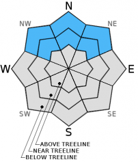
MODERATE avalanche danger still exists near and below treeline on NW-N-NE aspects on slopes steeper than 32 degrees due to lingering persistent slab instability.

Even though these slabs have become more difficult to trigger, human triggered avalanches remain possible in places where consistent snow cover exists.

1. Low

?

Above Treeline
Generally safe avalanche conditions. Watch for unstable snow on isolated terrain features.

2. Moderate

?

Near Treeline
Heightened avalanche conditions on specific terrain features. Evaluate snow and terrain carefully; identify features of concern.

2. Moderate

?

Below Treeline
Heightened avalanche conditions on specific terrain features. Evaluate snow and terrain carefully; identify features of concern.
    Heightened avalanche conditions on specific terrain features. Evaluate snow and terrain carefully; identify features of concern.
Avalanche Problem 1: Persistent Slab
  • Type ?
  • Aspect/Elevation ?
  • Likelihood ?
    Certain
    Very Likely
    Likely
    Possible
    Unlikely
  • Size ?
    Historic
    Very Large
    Large
    Small

Persistent slabs still exist on the NW-N-NE near and below treeline aspects. The persistent weak layer near the base of the snowpack has shown some signs of strengthening in some areas. In other areas the overlying slab has eroded away. However, in many areas a slab still sits on top of a fragile weak layer waiting for the right trigger to break it loose. A person's weight on the snowpack in the right spot can still trigger an avalanche.

The increase in variability and uncertainty associated with the persistent slabs makes it very difficult to accurately access snowpack stability. Even though most observations may point to a stable slope, it only takes finding that one hidden trigger point to start a failure that could take down the whole slope. Using the terrain to avoid the avalanche hazard by recreating on lower angle slopes that remain disconnected from steeper and deeper terrain represents a fun and safe plan when conditions like this exist.

Between the lingering persistent slabs and the shallow snow cover over rocks, logs, and other objects, significant hazards exist in the backcountry.

recent observations

Observations on Rubicon Peak (more info, video) yesterday showed that weak sugary snow grains (Dec 7th facets) still exist in the bottom half of the snowpack. Above this persistent weak layer, more consolidated slab-like layers of snow existed in most places between 7600ft. and 9000ft. In some areas these more consolidated layers had started to lose strength and become less slab like. Tests on the snowpack yielded unstable results indicating that fractures can still travel easily through the Dec 7th facets as well as results that indicated that fracture propagation has become unlikely.  Often these contradicting tests occurred right next to each other on the same slope. Tests also indicated that fractures are more likely to start and propagate from areas where a shallower snowpack exists or from trigger points like shallowly buried rocks. Trying to find these trigger points on a snow covered open slope would be quite difficult without x-ray vision. 

Overall data from around the forecast area indicates snowpack whose stability or instability varies greatly from slope to slope or even across an individual slope.

Weather and CURRENT CONDITIONS
weather summary

A low pressure north of the area should push some clouds into the region during the next 24 hrs. Other than that increase in clouds, expect more dry, warm, and mostly uneventful weather over the forecast area due to the high pressure ridge parked over the region. Daytime highs should climb into the mid 40's above 7000ft. for the next two days, and light to moderate southwest winds should prevail.

CONDITIONS ALONG THE SIERRA CREST BETWEEN 8200 FT. AND 9200 FT. IN THE LAST 24 HOURS
6am temperature: 32 to 41 deg. F.
Max. temperature: 42 to 49 deg. F.
Average ridgetop wind direction: Southwest
Average ridgetop wind speed: 5 to 10 mph
Maximum ridgetop wind gust: 21 mph
New snowfall: 0 inches
Total snow depth: 8 to 15 inches
Two-Day Mountain Weather Forecast Produced in partnership with the Reno NWS
For 7000 ft. to 8000 ft.
Monday Monday Night Tuesday
Weather: Partly cloudy Partly cloudy with cloud cover increasing overnight Mostly cloudy with some clearing throughout the day
Temperatures: 46 to 51 deg. F. 32 to 39 deg. F. 44 to 49 deg. F.
Mid Slope Winds: Variable Southwest Variable
Wind Speed: Light 10-15 mph Light
Expected snowfall: 0 0 0
For 8000 ft. to 9000 ft.
Monday Monday Night Tuesday
Weather: Partly cloudy Partly cloudy with cloud cover increasing overnight Mostly cloudy with some clearing throughout the day
Temperatures: 41 to 48 deg. F. 29 to 39 deg. F. 39 to 46 deg. F.
Ridge Top Winds: Southwest Southwest Southwest
Wind Speed: 15 to 20 mph with gusts to 30 mph 15 to 25 mph with gusts to 35 mph 15 to 25 mph with gusts to 35 mph
Expected snowfall: 0 0 0
Disclaimer

This avalanche advisory is provided through a partnership between the Tahoe National Forest and the Sierra Avalanche Center. This advisory covers the Central Sierra Nevada Mountains between Yuba Pass on the north and Ebbetts Pass on the south. Click here for a map of the forecast area. This advisory applies only to backcountry areas outside established ski area boundaries. This advisory describes general avalanche conditions and local variations always occur. This advisory expires 24 hours after the posted time unless otherwise noted. The information in this advisory is provided by the USDA Forest Service who is solely responsible for its content.