THIS AVALANCHE FORECAST EXPIRED ON January 4, 2014 @ 6:42 am
Avalanche Forecast published on January 3, 2014 @ 6:42 am
Issued by Brandon Schwartz - Tahoe National Forest

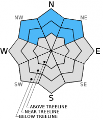
Pockets of  MODERATE avalanche danger remain near and below treeline on NW-N-NE aspects on slopes steeper than 32 degrees with consistent snow cover due to lingering persistent slabs. In these areas, the possibility of human triggered avalanches remains ongoing. For all other areas avalanche danger is either LOW or non-existent due to the lack of snow cover.

1. Low

?

Above Treeline
Generally safe avalanche conditions. Watch for unstable snow on isolated terrain features.

2. Moderate

?

Near Treeline
Heightened avalanche conditions on specific terrain features. Evaluate snow and terrain carefully; identify features of concern.

2. Moderate

?

Below Treeline
Heightened avalanche conditions on specific terrain features. Evaluate snow and terrain carefully; identify features of concern.
    Heightened avalanche conditions on specific terrain features. Evaluate snow and terrain carefully; identify features of concern.
Avalanche Problem 1: Persistent Slab
  • Type ?
  • Aspect/Elevation ?
  • Likelihood ?
    Certain
    Very Likely
    Likely
    Possible
    Unlikely
  • Size ?
    Historic
    Very Large
    Large
    Small

Variability in avalanche danger exists around the forecast area. Persistent slabs linger in some areas near treeline and below treeline on NW-N-NE aspects due to the presence of the faceted Dec 7 persistent weak layer. Field observations of the past 3+ weeks have shown the greatest amount of ongoing instability with little to no week to week stability improvement in the Carson Pass and Pole Creek/Deep Creek areas. Observations from the Yuba Pass, Mount Rose, Donner Summit, West Shore Tahoe, and Echo Summit areas have shown significantly less ongoing instability and in some cases stable conditions near treeline and below treeline on NW-N-NE aspects.

Triggering and going for a short ride in even a small avalanche at this time will almost certainly have significantly elevated consequences due to the almost guaranteed impact with rocks, logs, or trees due to the shallow snowpack. Becoming caught in the same size avalanche above a more typical deep Sierra snowpack could very well have minimal consequences.

recent observations

Observations made yesterday on Lincoln Ridge (Yuba Pass area) fell in line with the stable side of the the current spacial variability that exists near treeline and below treeline on NW-N-NE aspects around the forecast area (see the scroll below for pit profile, photo, and more info).

This remains in great contrast to the areas of significant ongoing persistent weak instability on the Dec 7 facet layer exemplified by what was observed in the Carson Pass area on Dec 31. Travel on near treeline and below treeline N-NE aspects in the area south of Red Lake produced cracking and collapsing of the snowpack. Some of the collapses occurred on the same slopes and areas previously collapsed by the same forecaster traveling through the area on Dec 12. Click here and watch the video showing very impressive collapse and propagation of the faceted Dec 7 persistent weak layer along a 2 meter (6.6ft) wide extended column test in this area. It is an excellent illustrator of the ongoing snowpack instability that has persisted for nearly a month in some areas.

Avalanche danger on SE-S-SW-W aspects has been almost entirely eliminated due to melt. Some snow cover exists on E aspects, but the Dec 7 facet layer has not been observed at any elevation on E aspects. The Dec 7 facet layer is also absent above treeline on NW-N-NE aspects. This is allowing for LOW avalanche danger in these areas. Near treeline and below treeline on NW-N-NE aspects, continued snowpack settlement has reduced the overall snowpack height and allowed rocks, logs, and stumps to show through the snowpack in places that were previously covered.

Weather and CURRENT CONDITIONS
weather summary

The high pressure currently over the forecast area will weaken slightly today as a weather system passes well to the east of the forecast area. A dry cold front will move through the region later today and tomorrow. This will mainly serve to increase winds and cool air temperatures 5 to 10 degrees at the mid and upper elevations. The air temperature inversion holding over the area is expected to mix out for a day or so. Ridgetop winds remain out of the southwest to west this morning and are light in speed. Moderate speed west winds are expected this afternoon through tomorrow morning, shifting to the east by tomorrow afternoon.

CONDITIONS ALONG THE SIERRA CREST BETWEEN 8200 FT. AND 9200 FT. IN THE LAST 24 HOURS
6am temperature: 37 to 42 deg. F.
Max. temperature: 46 to 51 deg. F.
Average ridgetop wind direction: SW
Average ridgetop wind speed: 14 mph
Maximum ridgetop wind gust: 24 mph
New snowfall: 0 inches
Total snow depth: 7 to 13 inches
Two-Day Mountain Weather Forecast Produced in partnership with the Reno NWS
For 7000 ft. to 8000 ft.
Friday Friday Night Saturday
Weather: Some high level clouds creating partly cloudy skies. Clear skies. Sunny skies.
Temperatures: 49 to 55 deg. F. 28 to 38 deg. F. 40 to 47 deg. F.
Mid Slope Winds: West West Northwest shifting to East by the afternoon.
Wind Speed: Light winds increasing to 10 to 15 mph with gusts to 25 mph in the afternoon. 10 to 15 mph. Gusts up to 25 mph in the evening. 10 to 15 mph with gusts to 25 mph.
Expected snowfall: 0 0 0
For 8000 ft. to 9000 ft.
Friday Friday Night Saturday
Weather: Some high level clouds creating partly cloudy skies. Clear skies. Sunny skies.
Temperatures: 40 to 50 deg. F. 30 to 40 deg. F. 35 to 45 deg. F.
Ridge Top Winds: West West West shifting to East by the afternoon.
Wind Speed: 10 to 15 mph with gusts to 25 mph, increasing to 20 to 25 mph with gusts to 35 mph in the afternoon. 15 to 20 mph with gusts to 35 mph. 15 to 20 mph. Gusts up to 30 mph.
Expected snowfall: 0 0 0
Disclaimer

This avalanche advisory is provided through a partnership between the Tahoe National Forest and the Sierra Avalanche Center. This advisory covers the Central Sierra Nevada Mountains between Yuba Pass on the north and Ebbetts Pass on the south. Click here for a map of the forecast area. This advisory applies only to backcountry areas outside established ski area boundaries. This advisory describes general avalanche conditions and local variations always occur. This advisory expires 24 hours after the posted time unless otherwise noted. The information in this advisory is provided by the USDA Forest Service who is solely responsible for its content.