THIS AVALANCHE FORECAST EXPIRED ON January 8, 2014 @ 7:00 am
Avalanche Forecast published on January 7, 2014 @ 7:00 am
Issued by Andy Anderson - Tahoe National Forest - Sierra Avalanche Center

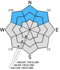
The avalanche danger has dropped to LOW on all snow covered slopes due to a shrinking snowpack. Human triggered avalanches are unlikely today but not impossible. Some persistent slabs may continue to lurk on isolated terrain features. The SE-S-SW-W aspects do not have enough snow cover on them to warrant a danger rating.

1. Low

?

Above Treeline
Generally safe avalanche conditions. Watch for unstable snow on isolated terrain features.

1. Low

?

Near Treeline
Generally safe avalanche conditions. Watch for unstable snow on isolated terrain features.

1. Low

?

Below Treeline
Generally safe avalanche conditions. Watch for unstable snow on isolated terrain features.
    Generally safe avalanche conditions. Watch for unstable snow on isolated terrain features.
Avalanche Problem 1: Persistent Slab
  • Type ?
  • Aspect/Elevation ?
  • Likelihood ?
    Certain
    Very Likely
    Likely
    Possible
    Unlikely
  • Size ?
    Historic
    Very Large
    Large
    Small

As the snowpack has become more shallow, the persistent slabs have fragmented and no longer connect across large slopes. This loss of snow has also decreased the weight on top of the persistent weak layers. Additionally, the overlying slab has lost strength and become less of a slab, and the persistent weak layer has had a month to adjust to the load above it. All of these factors combined have made triggering persistent slab avalanches unlikely. Unlikely does not mean impossible. Some unstable persistent slabs may still lurk on isolated terrain features on NW-N-NE aspects. These avalanches would remain small due to the lack of snow; however, getting caught in one of them would result in collisions with rocks, logs, or trees due to that same shallow snowpack.

Even though the avalanche danger has deceased, the barely covered rocks, logs, trees, stumps, and other obstacles including areas of bare ground on all aspects still make on-the-snow-recreation challenging. All of these things have become difficult to avoid, and collisions with these things could easily injure a person or break equipment. 

recent observations

After a month of observations that predominately indicated an unstable snowpack, the last 4 days of observations have shown a trend toward more stable conditions. Yesterday, observations and data did not reveal any signs of continued instability from an area near Red Lake (snowpit, more info) that had consistently yielded obvious unstable results since Dec. 7th. The weak sugary layer of snow in the bottom third of the snowpack still exists, but tests on this layer indicated that triggering a fracture that travels along this layer has become unlikely. This data matches the data collected earlier this week in Deep Creek, on Rubicon Peak, and on Lincoln Ridge.

Overall, finding areas with consistent snow cover has become more and more difficult. With each passing dry day the already anemic snowpack continues to wither away exposing more and more obstacles and areas of exposed ground.

Weather and CURRENT CONDITIONS
weather summary

Another weak disturbance should move past the region today. This system will bring an increase in cloud cover and southwest winds but should not carry any precipitation with it. Tomorrow a similar weak and dry system should impact the forecast area. These small systems come as part of a series that should culminate on Thurday when the strongest system of the series should arrive. Check out the Reno NWS for more details.

CONDITIONS ALONG THE SIERRA CREST BETWEEN 8200 FT. AND 9200 FT. IN THE LAST 24 HOURS
6am temperature: 28 to 34 deg. F.
Max. temperature: 40 to 46 deg. F.
Average ridgetop wind direction: Southwest
Average ridgetop wind speed: 20 to 25 mph
Maximum ridgetop wind gust: 46 mph
New snowfall: 0 inches
Total snow depth: 7 to 13 inches
Two-Day Mountain Weather Forecast Produced in partnership with the Reno NWS
For 7000 ft. to 8000 ft.
Tuesday Tuesday Night Wednesday
Weather: Partly cloudy Partly cloudy becoming mostly cloudy overnight Mostly cloudy
Temperatures: 38 to 45 deg. F. 24 to 30 deg. F. 36 to 43 deg. F.
Mid Slope Winds: Southwest Southwest Southwest
Wind Speed: 15 to 20 mph with gusts to 30 mph 15 to 20 mph with gusts to 30 mph 10 to 15 mph with gusts to 25 mph
Expected snowfall: 0 0 0
For 8000 ft. to 9000 ft.
Tuesday Tuesday Night Wednesday
Weather: Partly cloudy Partly cloudy becoming mostly cloudy overnight Mostly cloudy
Temperatures: 38 to 44 deg. F. 21 to 28 deg. F. 33 to 40 deg. F.
Ridge Top Winds: Southwest Southwest Southwest
Wind Speed: 20 to 30 mph with gusts to 45 mph 20 to 30 mph with gusts to 45 mph 15 to 25 mph with gusts to 40 mph
Expected snowfall: 0 0 0
Disclaimer

This avalanche advisory is provided through a partnership between the Tahoe National Forest and the Sierra Avalanche Center. This advisory covers the Central Sierra Nevada Mountains between Yuba Pass on the north and Ebbetts Pass on the south. Click here for a map of the forecast area. This advisory applies only to backcountry areas outside established ski area boundaries. This advisory describes general avalanche conditions and local variations always occur. This advisory expires 24 hours after the posted time unless otherwise noted. The information in this advisory is provided by the USDA Forest Service who is solely responsible for its content.