THIS AVALANCHE FORECAST EXPIRED ON January 9, 2014 @ 6:51 am
Avalanche Forecast published on January 8, 2014 @ 6:51 am
Issued by Brandon Schwartz - Tahoe National Forest

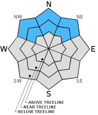
Avalanche danger is LOW for snow covered areas at all elevations on NW-N-NE-E aspects. For all other areas, avalanche danger is generally non-existant due to a lack of snow cover.

1. Low

?

Above Treeline
Generally safe avalanche conditions. Watch for unstable snow on isolated terrain features.

1. Low

?

Near Treeline
Generally safe avalanche conditions. Watch for unstable snow on isolated terrain features.

1. Low

?

Below Treeline
Generally safe avalanche conditions. Watch for unstable snow on isolated terrain features.
    Generally safe avalanche conditions. Watch for unstable snow on isolated terrain features.
Avalanche Problem 1: Persistent Slab
  • Type ?
  • Aspect/Elevation ?
  • Likelihood ?
    Certain
    Very Likely
    Likely
    Possible
    Unlikely
  • Size ?
    Historic
    Very Large
    Large
    Small

The remote possibility of finding that third scenario of the unlikely but not impossible to trigger persistent slab is just enough to warrant continued caution and diligent best practice travel techniques in the backcountry. The faceted Dec 7 persistent weak layer remained reactive for 3+ weeks following the snowfall event that buried and loaded it. It has just recently gone quiet in the areas sampled by field observations. Near treeline and below treeline slopes on NW-N-NE aspects that hold continuous snow cover still deserve respect. No one will care how "unlikely" triggering is on a regional scale if caught in an avalanche on the one slope for miles around that still holds instability. Persistent weak layers are stubborn that way.

recent observations

Observations made yesterday in the Mount Rose Backcountry fell in line with other observations from around the forecast area over the past several days. Where areas of continuous snow cover exist near treeline and below treeline on NW-N-NE aspects, generally one of two snowpack scenarios is found. Either the faceted Dec 7 layer has gained enough strength that failure has become unlikely under the current level of load or the slab sitting on top of the Dec 7 facet layer has lost so much cohesion through the near surface faceting process that it will no longer sustain propagation upon collapse. Either way human triggered avalanches have become unlikely at this time. Finding a third scenario of a lingering pocket of isolated persistent slab instability on an isolated terrain feature somewhere within the forecast area is unlikely but not impossible.

Weather and CURRENT CONDITIONS
weather summary

A brief period of clear skies will occur this morning between passing weather systems. Ridgetop winds remain out of the west this morning and are moderate in speed. Maximum daytime air temperatures are forecast to reach the mid 30s to low 40s today for areas above 7,000'. Cloud cover will increase this afternoon ahead of the next approaching weather system which is expected to bring increased winds, light snow showers, and a weak cold front to the region overnight into tomorrow morning. A period of sunshine is expected Friday before the last and strongest of the current series of weather systems moves into the west coast on Saturday.

CONDITIONS ALONG THE SIERRA CREST BETWEEN 8200 FT. AND 9200 FT. IN THE LAST 24 HOURS
6am temperature: 24 to 31 deg. F.
Max. temperature: 34 to 42 deg. F.
Average ridgetop wind direction: West
Average ridgetop wind speed: 27 mph
Maximum ridgetop wind gust: 41 mph
New snowfall: 0 inches
Total snow depth: 7 to 13 inches
Two-Day Mountain Weather Forecast Produced in partnership with the Reno NWS
For 7000 ft. to 8000 ft.
Wednesday Wednesday Night Thursday
Weather: Partly cloudy skies, becoming mostly cloudy. Mostly cloudy skies. Cloudy skies, becoming mostly cloudy. A slight chance of snow.
Temperatures: 35 to 43 deg. F. 19 to 26 deg. F. 29 to 36 deg. F.
Mid Slope Winds: Southwest West West
Wind Speed: 10 to 15 mph with gusts to 25 mph. 15 to 25 mph with gusts to 35 mph. 20 to 30 mph with gusts to 45 mph.
Expected snowfall: 0 0 0 to trace
For 8000 ft. to 9000 ft.
Wednesday Wednesday Night Thursday
Weather: Partly cloudy skies, becoming mostly cloudy. Mostly cloudy skies. Cloudy skies, becoming mostly cloudy. A slight chance of snow.
Temperatures: 31 to 38 deg. F. 19 to 26 deg. F. 28 to 34 deg. F.
Ridge Top Winds: West West West
Wind Speed: 20 to 30 mph with gusts to 40 mph. 30 to 40 mph with gusts to 60 mph. 35 to 45 mph with gusts to 65 mph.
Expected snowfall: 0 0 0 to trace
Disclaimer

This avalanche advisory is provided through a partnership between the Tahoe National Forest and the Sierra Avalanche Center. This advisory covers the Central Sierra Nevada Mountains between Yuba Pass on the north and Ebbetts Pass on the south. Click here for a map of the forecast area. This advisory applies only to backcountry areas outside established ski area boundaries. This advisory describes general avalanche conditions and local variations always occur. This advisory expires 24 hours after the posted time unless otherwise noted. The information in this advisory is provided by the USDA Forest Service who is solely responsible for its content.