


For 7000 ft. to 8000 ft.
| Saturday | Saturday Night | Sunday | |
|---|---|---|---|
| Weather: | Mostly couldy with isolated snow showers in the morning. Snow becoming more widespread this afternoon. | Mostly cloudy with some scattered snow showers in the evening. Snow tapering off overnight. | Partly cloudy in the morning becoming sunny by the afternoon |
| Temperatures: | 37 to 42 deg. F. | 20 to 25 deg. F. | 35 to 40 deg. F. |
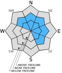
| Mid Slope Winds: | Southwest | Southwest | Northwest shifing to the Northeast in the afternoon |
| Wind Speed: | 30 to 45 mph with gusts to 75 mph | 30 to 40 mph with gusts to 70 mph decreasing to 15 to 25 mph with gusts to 45 mph after midnight | 10 to 15 mph increasing to 10 to 20 mph with gusts to 30 mph in the afternoon |
| Expected snowfall: | 1 to 3 | 0 | 0 |
For 8000 ft. to 9000 ft.
| Saturday | Saturday Night | Sunday | |
|---|---|---|---|
| Weather: | Mostly couldy with isolated snow showers in the morning. Snow becoming more widespread this afternoon. | Mostly cloudy with some scattered snow showers in the evening. Snow tapering off overnight. | Partly cloudy in the morning becoming sunny by the afternoon |
| Temperatures: | 31 to 38 deg. F. | 20 to 25 deg. F. | 28 to 33 deg. F. |
| Ridge Top Winds: | Southwest | West shifting to the Northwest after midnight | Northwest shifing to the North in the afternoon |
| Wind Speed: | 45 to 60 mph with gusts to 90 mph increasing to 55 to 70 mph with gusts to 105 mph in the afternoon | 50 to 60 mph with gusts to 95 mph decreasing to 30 to 45 mph with gusts to 80 mph after midnight | 25 to 40 mph with gusts to 65 mph deceasing to 20 to 30 mph with gusts to 45 mph in the afternoon |
| Expected snowfall: | 3 to 5 | 0 | 0 |


