THIS AVALANCHE FORECAST EXPIRED ON January 13, 2014 @ 7:00 am
Avalanche Forecast published on January 12, 2014 @ 7:00 am
Issued by Andy Anderson - Tahoe National Forest - Sierra Avalanche Center

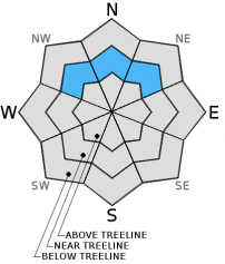
The avalanche danger is LOW for most areas with consistent snow cover and nonexistent for areas without snow. On a few of the near treeline NW-N-NE aspects that received the most snow yesterday, some pockets of MODERATE avalanche danger may exist where human triggered avalanches may be possible on slopes steeper than 32 degrees. These more fragile areas are mostly likely to exist where small wind slabs formed above persistent weak layers.

1. Low

?

Above Treeline
Generally safe avalanche conditions. Watch for unstable snow on isolated terrain features.

2. Moderate

?

Near Treeline
Heightened avalanche conditions on specific terrain features. Evaluate snow and terrain carefully; identify features of concern.

1. Low

?

Below Treeline
Generally safe avalanche conditions. Watch for unstable snow on isolated terrain features.
    Heightened avalanche conditions on specific terrain features. Evaluate snow and terrain carefully; identify features of concern.
Avalanche Problem 1: Persistent Slab
  • Type ?
  • Aspect/Elevation ?
  • Likelihood ?
    Certain
    Very Likely
    Likely
    Possible
    Unlikely
  • Size ?
    Historic
    Very Large
    Large
    Small

In most areas yesterday's meager amounts of new snow were not enough to change the avalanche conditions. However, a few areas did report 4 to 6 inches of new snow with strong winds. Some of these areas represent the places where signs of instability lasted the longest in regards to the Dec. 7th facet layers. On some near treeline NW-N-NE aspects, the 4 to 6 inches of new snow may have formed small soft slabs or combined with the winds to form a small wind slabs that would allow the possibility of humans breaking the buried persistent weak layer and causing an avalanche. The places that reported the most snow are scattered along the Sierra Crest. Due to the variable winds, variable accumulation amounts, and variation in weak layer strength, diligent observations to determine where wind slabs or soft slabs have formed and what kind of snowpack they formed above will be necessary to determine which pockets of terrain may hold fragile persistent slab avalanche conditions today.

recent observations

Yesterday on Andesite Ridge, old weak snow (Dec. 7th facets) still existed in the bottom third of the snowpack on the near and below treeline N-NE aspects. Above this more weak snow resided. The 2 to 3 inches of new snow that had fallen by 3pm had not formed a slab nor did it add enough weight to the snowpack to reactivate those buried weak layers. Above treeline the new snow fell on scoured slopes where numerous rocks and other obstacles still remain uncovered. In this area observations did not reveal any signs of instability yesterday. The only wind slabs noted had formed along the ridge. They were very small (less than 8 inches deep and a few feet wide) and were well anchored by the exposed obstacles.

Weather and CURRENT CONDITIONS
weather summary

Yesterday's storm left 2 to 4 inches of new snow behind in most places. A few of the remote sensors along the Sierra Crest reported storm totals as high as 6 inches. The skies cleared last night after the storm ended, and temperatures dropped into the upper teens and low 20's. The winds have started to shift to the North as a high pressure rebuilds over the region. Expect clear sunny skies and light to moderate northerly winds through tomorrow.  After a day of temperatures in the 30's above 7000 ft. today, the high pressure should bring a warming trend for the rest of the week.

CONDITIONS ALONG THE SIERRA CREST BETWEEN 8200 FT. AND 9200 FT. IN THE LAST 24 HOURS
6am temperature: 15 to 21 deg. F.
Max. temperature: 30 to 35 deg. F.
Average ridgetop wind direction: Southwest
Average ridgetop wind speed: Before midnight: 35 to 45 mph | Since midnight: 20 mph
Maximum ridgetop wind gust: 85 mph
New snowfall: 2 to 6 inches
Total snow depth: 12 to 17 inches
Two-Day Mountain Weather Forecast Produced in partnership with the Reno NWS
For 7000 ft. to 8000 ft.
Sunday Sunday Night Monday
Weather: Mostly sunny Clear Sunny
Temperatures: 35 to 40 deg. F. 21 to 27 deg. F. 43 to 48 deg. F.
Mid Slope Winds: Northeast East East
Wind Speed: 10 to 15 mph with gusts to 25 mph 10 to 15 mph with gusts to 25 mph 10 to 15 mph with gusts to 25 mph in the morning
Expected snowfall: 0 0 0
For 8000 ft. to 9000 ft.
Sunday Sunday Night Monday
Weather: Mostly sunny Clear Sunny
Temperatures: 30 to 35 deg. F. 19 to 26 deg. F. 39 to 46 deg. F.
Ridge Top Winds: North Northeast Northeast
Wind Speed: 15 to 25 mph with gusts to 35 mph 15 to 25 mph with gusts to 40 mph 15 to 25 mph with gusts to 40 mph
Expected snowfall: 0 0 0
Disclaimer

This avalanche advisory is provided through a partnership between the Tahoe National Forest and the Sierra Avalanche Center. This advisory covers the Central Sierra Nevada Mountains between Yuba Pass on the north and Ebbetts Pass on the south. Click here for a map of the forecast area. This advisory applies only to backcountry areas outside established ski area boundaries. This advisory describes general avalanche conditions and local variations always occur. This advisory expires 24 hours after the posted time unless otherwise noted. The information in this advisory is provided by the USDA Forest Service who is solely responsible for its content.