THIS AVALANCHE FORECAST EXPIRED ON January 15, 2014 @ 6:53 am
Avalanche Forecast published on January 14, 2014 @ 6:53 am
Issued by Brandon Schwartz - Tahoe National Forest

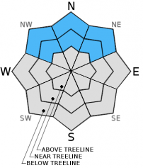
Avalanche danger is LOW at all elevations on snow covered NW-N-NE-E aspects. Human triggered avalanches are unlikely but not impossible. Isolated areas of unstable snow may exist on isolated terrain features. Due to melt, avalanche danger on SE-S-SW-W aspects is generally nonexistent.

1. Low

?

Above Treeline
Generally safe avalanche conditions. Watch for unstable snow on isolated terrain features.

1. Low

?

Near Treeline
Generally safe avalanche conditions. Watch for unstable snow on isolated terrain features.

1. Low

?

Below Treeline
Generally safe avalanche conditions. Watch for unstable snow on isolated terrain features.
    Generally safe avalanche conditions. Watch for unstable snow on isolated terrain features.
Avalanche Problem 1: Normal Caution
  • Type ?
  • Aspect/Elevation ?
  • Likelihood ?
    Certain
    Very Likely
    Likely
    Possible
    Unlikely
  • Size ?
    Historic
    Very Large
    Large
    Small

Generally stable snowpack conditions exist on a regional scale. The unlikely possibility of triggering an isolated wind slab or persistent slab avalanche continues to linger on NW-N-NE aspects. Recent field observations still show the occasional unstable snowpit test result mixed in among a majority of stable snowpit test results. Continue to exercise caution and implement best travel practices while traveling in or below avalanche terrain in order to minimize risk.

recent observations

The existing snowpack is generally stable, despite the presence of various weak layers and measuring in at just 20% of average depth for this time of year. Observations made yesterday on Rubicon Peak (West Shore Tahoe area) revealed stable slab conditions overlying various faceted weak layers on below treeline northerly aspects. In the big picture, the snowpack remains weak, but the facet layers have gained sufficient strength to support the overlying slab. In some areas, the surface slab has disintegrated through near surface faceting and no longer exists.

A guided group on the traditionally heavily wind loaded Wildflower Ridge, a N and NE aspect at 7,700' on Mt. Judah (Donner Summit area) reported ongoing propagation potential but significant difficulty in trigger collapse of the Dec 7 facet layer. Minor cracking was also observed in this area once surface wind slabs sitting on a buried graupel layer were undercut by ski tracks. These shallow wind slabs also proved difficult to trigger if not previously undercut.

Weather and CURRENT CONDITIONS
weather summary

High pressure is firmly in place over the forecast area. Sunny skies, air temperature inversion, and east winds are forecast for the next several days. Remote sensors are reporting air temperatures this morning well into the 30s above 6,500' with 20s on the mountain valley floors. Maximum daytime air temperatures are forecast to reach well into the 40s today for areas above 7,000'. Moderate speed east winds are expected to continue over ridgetops today, tonight, and tomorrow.

This is the current long term weather forecast from NWS Reno: "Long term precipitation outlook continues to be bleak. Ensemble forecasts and analogs continue to show no signs of dislodging the tenacious high pressure anomaly from the west coast for at least another 2 weeks. As most of January will likely stay dry, the 2014 water year may go down as the driest 4 month start to a water year in recorded history for the Sierra."

CONDITIONS ALONG THE SIERRA CREST BETWEEN 8200 FT. AND 9200 FT. IN THE LAST 24 HOURS
6am temperature: 32 to 37 deg. F.
Max. temperature: 39 to 47 deg. F.
Average ridgetop wind direction: East
Average ridgetop wind speed: 31 mph
Maximum ridgetop wind gust: 45 mph
New snowfall: 0 inches
Total snow depth: 10 to 17 inches
Two-Day Mountain Weather Forecast Produced in partnership with the Reno NWS
For 7000 ft. to 8000 ft.
Tuesday Tuesday Night Wednesday
Weather: Sunny skies. Clear skies. Sunny skies.
Temperatures: 44 to 49 deg. F. 28 to 35 deg. F. 45 to 50 deg. F.
Mid Slope Winds: East East East
Wind Speed: 10 to 15 mph. Gusts to 25 mph in the morning. 10 to 20 mph. Gusts up to 30 mph after midnight. 10 to 20 mph with gusts to 30 mph.
Expected snowfall: 0 0 0
For 8000 ft. to 9000 ft.
Tuesday Tuesday Night Wednesday
Weather: Sunny skies. Clear skies. Sunny skies.
Temperatures: 40 to 46 deg. F. 28 to 35 deg. F. 41 to 47 deg. F.
Ridge Top Winds: East East East
Wind Speed: 20 to 30 mph with gusts to 40 mph. 20 to 30 mph with gusts to 40 mph. 20 to 30 mph. Gusts up to 40 mph in the morning.
Expected snowfall: 0 0 0
Disclaimer

This avalanche advisory is provided through a partnership between the Tahoe National Forest and the Sierra Avalanche Center. This advisory covers the Central Sierra Nevada Mountains between Yuba Pass on the north and Ebbetts Pass on the south. Click here for a map of the forecast area. This advisory applies only to backcountry areas outside established ski area boundaries. This advisory describes general avalanche conditions and local variations always occur. This advisory expires 24 hours after the posted time unless otherwise noted. The information in this advisory is provided by the USDA Forest Service who is solely responsible for its content.