THIS AVALANCHE FORECAST EXPIRED ON January 17, 2014 @ 6:44 am
Avalanche Forecast published on January 16, 2014 @ 6:44 am
Issued by Brandon Schwartz - Tahoe National Forest

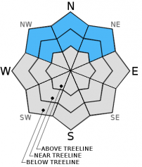
Avalanche danger is LOW for all elevations on snow covered NW-N-NE-E aspects. Encountering an isolated area of unstable snow has become unlikely, but may still be possible due to the variability that can exist on a regional scale. Due to melt, avalanche danger on SE-S-SW-W aspects is generally nonexistent.

1. Low

?

Above Treeline
Generally safe avalanche conditions. Watch for unstable snow on isolated terrain features.

1. Low

?

Near Treeline
Generally safe avalanche conditions. Watch for unstable snow on isolated terrain features.

1. Low

?

Below Treeline
Generally safe avalanche conditions. Watch for unstable snow on isolated terrain features.
    Generally safe avalanche conditions. Watch for unstable snow on isolated terrain features.
Avalanche Problem 1: Normal Caution
  • Type ?
  • Aspect/Elevation ?
  • Likelihood ?
    Certain
    Very Likely
    Likely
    Possible
    Unlikely
  • Size ?
    Historic
    Very Large
    Large
    Small

Any areas of instability that continue to exist are most likely to be found near treeline on NW-N-NE aspects were surface slabs sit on top of weaker faceted snow. Otherwise, generally stable snowpack conditions have been observed on a regional scale. Triggering an isolated wind slab or persistent slab avalanche is unlikely but not impossible. Recent field observations still show the occasional unstable snowpit test result mixed in among the vast majority of stable snowpit test results. Continue to exercise caution and implement best travel practices while traveling in or below avalanche terrain in order to minimize risk.

recent observations

Observations made yesterday on Lincoln Ridge (Yuba Pass area) revealed lingering wind slabs. These wind slabs had formed near treeline on northerly aspects during the January 11 snowfall event and were deposited on top of faceted snow. These slabs proved difficult to trigger and evidence of instability was limited. Once sufficient force was applied to collapse the faceted weak layer, snowpit tests indicated that the resulting fracture could propagate through the snowpack. The general trend recently observed in other locations around the forecast area has been indicative of better snowpack stability. Either the weak layers have sufficient strength to support the overlying load or the surface slab is not strong enough to allow snowpack collapse to travel any significant distance through the snowpack.

Weather and CURRENT CONDITIONS
weather summary

Strong high pressure, 4 to 5 standard deviations above normal remains in place over the region. Expect sunny skies, air temperature inversion, and east winds to continue for the remainder of this week. Remote sensors are reporting air temperatures this morning in the 30s for areas above 8,000' with teens on the mountain valley floors. Maximum daytime air temperatures are forecast to reach the mid 40s to mid 50s today for areas above 7,000'. Moderate speed east winds are expected to continue over ridgetops above 8,000' through tonight, becoming light tomorrow.

CONDITIONS ALONG THE SIERRA CREST BETWEEN 8200 FT. AND 9200 FT. IN THE LAST 24 HOURS
6am temperature: 31 to 37 deg. F.
Max. temperature: 41 to 48 deg. F.
Average ridgetop wind direction: East
Average ridgetop wind speed: 37 mph
Maximum ridgetop wind gust: 54 mph
New snowfall: 0 inches
Total snow depth: 10 to 18 inches
Two-Day Mountain Weather Forecast Produced in partnership with the Reno NWS
For 7000 ft. to 8000 ft.
Thursday Thursday Night Friday
Weather: Sunny skies. Clear skies. Sunny skies.
Temperatures: 50 to 55 deg. F. 30 to 38 deg. F. 51 to 56 deg. F.
Mid Slope Winds: East Southeast Southeast
Wind Speed: 10 to 15 mph. 5 to 10 mph. Light winds.
Expected snowfall: 0 0 0
For 8000 ft. to 9000 ft.
Thursday Thursday Night Friday
Weather: Sunny skies. Clear skies. Sunny skies.
Temperatures: 44 to 51 deg. F. 31 to 37 deg. F. 46 to 52 deg. F.
Ridge Top Winds: East Southeast Southeast
Wind Speed: 15 to 20 mph with gusts to 30 mph. 10 to 15 mph with gusts to 25 mph. 10 to 15 mph in the morning, becoming light.
Expected snowfall: 0 0 0
Disclaimer

This avalanche advisory is provided through a partnership between the Tahoe National Forest and the Sierra Avalanche Center. This advisory covers the Central Sierra Nevada Mountains between Yuba Pass on the north and Ebbetts Pass on the south. Click here for a map of the forecast area. This advisory applies only to backcountry areas outside established ski area boundaries. This advisory describes general avalanche conditions and local variations always occur. This advisory expires 24 hours after the posted time unless otherwise noted. The information in this advisory is provided by the USDA Forest Service who is solely responsible for its content.