THIS AVALANCHE FORECAST EXPIRED ON January 18, 2014 @ 7:00 am
Avalanche Forecast published on January 17, 2014 @ 7:00 am
Issued by Andy Anderson - Tahoe National Forest - Sierra Avalanche Center

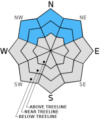
Avalanche danger remains LOW on snow covered NW-N-NE-E aspects. A few small areas of unstable snow may still exist on isolated terrain features. On SE-S-SW-W aspects a lack of snow makes the avalanche danger generally nonexistent.

1. Low

?

Above Treeline
Generally safe avalanche conditions. Watch for unstable snow on isolated terrain features.

1. Low

?

Near Treeline
Generally safe avalanche conditions. Watch for unstable snow on isolated terrain features.

1. Low

?

Below Treeline
Generally safe avalanche conditions. Watch for unstable snow on isolated terrain features.
    Generally safe avalanche conditions. Watch for unstable snow on isolated terrain features.
Avalanche Problem 1: Normal Caution
  • Type ?
  • Aspect/Elevation ?
  • Likelihood ?
    Certain
    Very Likely
    Likely
    Possible
    Unlikely
  • Size ?
    Historic
    Very Large
    Large
    Small

A shallow snowpack with buried persistent weak layers still exists on NW-N-NE aspects. At this time data and observations indicate that triggering an avalanche is unlikely. A few isolated pieces of data indicating instability still continue to crop up in day to day field observations. Finding some unstable snow in the form of a small persistent slab or small wind slab on an isolated terrain feature on a NW-N-NE aspect is not impossible. Continue to exercise caution and use safe travel practices if traveling in or below avalanche terrain in order to minimize risk.

recent observations

Observations near Grouse Rocks yesterday showed similar conditions to those seen at other locations around the forecast area. On N-NE aspects a shallow snowpack consisting of weak sugary snow capped by the most recent snow exists. Most data has indicated that the weak sugary snow buried in the snowpack can support the small slabs that exist above it in some areas. In the areas where these small slabs do not exist, more weak snow sits above these buried weak layers. Yesterday in the near and above treeline areas some wind slabs did still remain on top of the snowpack. Most tests indicated that these slabs have settled and bonded to the snow below them and that they remain difficult to trigger. However a few isolated tests still indicated that fractures could travel through the snowpack just below the wind slabs. 

Weather and CURRENT CONDITIONS
weather summary

The high pressure ridge over the region that the Sacramento NWS has termed the "Ridiculously Resilient Ridge" will keep the weather sunny, warm, and dry during the days and cold and clear at night. This pattern shows no signs of breaking this week and will go down as one of the most persistent high pressure ridges in this area's history. The Sacramento area will most likely break a record for the most consecutive days without precipitation this week. Click here for more info.

CONDITIONS ALONG THE SIERRA CREST BETWEEN 8200 FT. AND 9200 FT. IN THE LAST 24 HOURS
6am temperature: 30 to 43 deg. F.
Max. temperature: 42 to 48 deg. F.
Average ridgetop wind direction: Before midnight: East | After midnight: Variable
Average ridgetop wind speed: Before midnight: 25 to 35 mph | After midnight: 0 to 10 mph
Maximum ridgetop wind gust: 52 mph
New snowfall: 0 inches
Total snow depth: 10 to 17 inches
Two-Day Mountain Weather Forecast Produced in partnership with the Reno NWS
For 7000 ft. to 8000 ft.
Friday Friday Night Saturday
Weather: Sunny Clear Sunny
Temperatures: 43 to 50 deg. F. 24 to 32 deg. F. 44 to 51 deg. F.
Mid Slope Winds: Variable Variable Variable
Wind Speed: Light Light Light
Expected snowfall: 0 0 0
For 8000 ft. to 9000 ft.
Friday Friday Night Saturday
Weather: Sunny Clear Sunny
Temperatures: 44 to 50 deg. F. 29 to 35 deg. F. 45 to 51 deg. F.
Ridge Top Winds: Variable Variable Variable
Wind Speed: Light Light Light
Expected snowfall: 0 0 0
Disclaimer

This avalanche advisory is provided through a partnership between the Tahoe National Forest and the Sierra Avalanche Center. This advisory covers the Central Sierra Nevada Mountains between Yuba Pass on the north and Ebbetts Pass on the south. Click here for a map of the forecast area. This advisory applies only to backcountry areas outside established ski area boundaries. This advisory describes general avalanche conditions and local variations always occur. This advisory expires 24 hours after the posted time unless otherwise noted. The information in this advisory is provided by the USDA Forest Service who is solely responsible for its content.