THIS AVALANCHE FORECAST EXPIRED ON January 22, 2014 @ 6:45 am
Avalanche Forecast published on January 21, 2014 @ 6:45 am
Issued by Brandon Schwartz - Tahoe National Forest

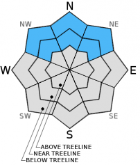
Avalanche danger is LOW at all elevations on snow covered NW-N-NE-E aspects. Avalanche danger is generally nonexistent on SE-S-SW-W aspects due to a lack of snowcover.

1. Low

?

Above Treeline
Generally safe avalanche conditions. Watch for unstable snow on isolated terrain features.

1. Low

?

Near Treeline
Generally safe avalanche conditions. Watch for unstable snow on isolated terrain features.

1. Low

?

Below Treeline
Generally safe avalanche conditions. Watch for unstable snow on isolated terrain features.
    Generally safe avalanche conditions. Watch for unstable snow on isolated terrain features.
Avalanche Problem 1: Normal Caution
  • Type ?
  • Aspect/Elevation ?
  • Likelihood ?
    Certain
    Very Likely
    Likely
    Possible
    Unlikely
  • Size ?
    Historic
    Very Large
    Large
    Small

At this time triggering an avalanche is unlikely on a regional scale. Given that the existing snowpack is composed mainly of weak faceted snow that looks nothing like what is typically found in this region at this time of year, finding a localized area of unstable snow is not an impossible scenario. The most likely area to encounter snowpack instability is near treeline and below treeline on NW-N-NE aspects. In these areas, well developed weak layers of faceted snow exist. The degree to which a slab capable of sustaining propagation exists on top of these weak layers is variable from one location to the next. In areas where a significant slab does exists, it has become very difficult to trigger. That said, keep the odds stacked in your favor by exposing only one person at a time to avalanche terrain and by moving from one well established safe zone to the next.

recent observations

Recent observations from around the forecast area indicate weak but stable snowpack conditions. The existing snowpack is generally limited to NW-N-NE-E aspects. It is composed mainly of faceted snow, with the deepest snowpack found near and below treeline on NW-N-NE aspects. These faceted weak layers have shown the ability to support the weight of the overlying snowpack plus the weight of a person in the areas sampled. Occasionally, snowpit tests point out that some of these weak layers still hold the ability to propagate if weak layer collapse could be triggered. At this time, triggering the necessary weak layer collapse is difficult to accomplish and unlikely to occur.

Weather and CURRENT CONDITIONS
weather summary

Dry shortwave weather systems passing through the region are having little effect on the existing high pressure. Ridgetop winds shifted from east to southwest last night and are light to moderate in speed this morning. Winds are forecast to shift to the northwest and northeast tonight, and become light. The well established pattern of light winds, morning air temperature inversion, and maximum daytime air temperatures in the 40s and 50s will persist today and tomorrow. A cool down of 10 to 15 degrees is expected for the second half of this week following a cold front passage Wednesday night.

CONDITIONS ALONG THE SIERRA CREST BETWEEN 8200 FT. AND 9200 FT. IN THE LAST 24 HOURS
6am temperature: 30 to 38 deg. F.
Max. temperature: 42 to 49 deg. F.
Average ridgetop wind direction: East shifting to southwest after midnight.
Average ridgetop wind speed: 15 mph
Maximum ridgetop wind gust: 31 mph
New snowfall: 0 inches
Total snow depth: 8 to 15 inches
Two-Day Mountain Weather Forecast Produced in partnership with the Reno NWS
For 7000 ft. to 8000 ft.
Tuesday Tuesday Night Wednesday
Weather: Some high clouds creating partly cloudy skies. Clear skies. Sunny skies.
Temperatures: 43 to 50 deg. F. 26 to 34 deg. F. 43 to 50 deg. F.
Mid Slope Winds: Southwest Northwest shifting to northeast North
Wind Speed: Light winds Light winds Light winds
Expected snowfall: 0 0 0
For 8000 ft. to 9000 ft.
Tuesday Tuesday Night Wednesday
Weather: Some high clouds creating partly cloudy skies. Clear skies. Sunny skies.
Temperatures: 42 to 48 deg. F. 29 to 37 deg. F. 42 to 48 deg. F.
Ridge Top Winds: Southwest Northwest shifting to northeast after midnight. North
Wind Speed: 10 to 15 mph 10 to 15 mph 10 to 15 mph
Expected snowfall: 0 0 0
Disclaimer

This avalanche advisory is provided through a partnership between the Tahoe National Forest and the Sierra Avalanche Center. This advisory covers the Central Sierra Nevada Mountains between Yuba Pass on the north and Ebbetts Pass on the south. Click here for a map of the forecast area. This advisory applies only to backcountry areas outside established ski area boundaries. This advisory describes general avalanche conditions and local variations always occur. This advisory expires 24 hours after the posted time unless otherwise noted. The information in this advisory is provided by the USDA Forest Service who is solely responsible for its content.