THIS AVALANCHE FORECAST EXPIRED ON January 24, 2014 @ 6:59 am
Avalanche Forecast published on January 23, 2014 @ 6:59 am
Issued by Andy Anderson - Tahoe National Forest - Sierra Avalanche Center

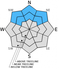
Avalanche danger remains LOW at all elevations on snow covered NW-N-NE-E aspects. Avalanche danger and snow cover are generally nonexistent on SE-S-SW-W aspects.

1. Low

?

Above Treeline
Generally safe avalanche conditions. Watch for unstable snow on isolated terrain features.

1. Low

?

Near Treeline
Generally safe avalanche conditions. Watch for unstable snow on isolated terrain features.

1. Low

?

Below Treeline
Generally safe avalanche conditions. Watch for unstable snow on isolated terrain features.
    Generally safe avalanche conditions. Watch for unstable snow on isolated terrain features.
Avalanche Problem 1: Normal Caution
  • Type ?
  • Aspect/Elevation ?
  • Likelihood ?
    Certain
    Very Likely
    Likely
    Possible
    Unlikely
  • Size ?
    Historic
    Very Large
    Large
    Small

Even though several weak layers exist in the snowpack, triggering an avalanche remains unlikely because not enough of a load resides above those buried weak layers. The vast majority of data indicates that the shallow and weak snowpack can support itself and people recreating on top of it in its current state. Day to day observations continue to yield a few isolated results indicating instability. This variability means that even though avalanches are unlikely, finding some unstable snow in the form of a small persistent slab on an isolated terrain feature on a NW-N-NE aspect is not impossible. Continue to evaluate the snowpack before committing to a slope and employ safe backcountry travel practices like traveling one at a time and spotting partners from known safe zones outside of any avalanche path. Numerous rocks, trees, stumps, logs and other obstacles remain exposed and could easily injure people or break equipment.

recent observations

Observations continue to show a shallow snowpack composed of several layers of weak snow. In some areas slab-like layers exist above weak layers, and in other areas they do not. Overall data and observations indicate that even though many weak layers exist in the snowpack, the snowpack can currently support itself and people recreating on top of it. Yesterday observations from Rubicon Peak also indicated a weak but stable snowpack. Data has shown that the snowpack continues to weaken and that depth hoar (very weak, large grained, sugary snow) exists near the base of the snowpack in some areas. If/when significant snow falls on top of the existing snowpack, these weak layers could create serious avalanche problems. 

Weather and CURRENT CONDITIONS
weather summary

Today's high temperatures should remain 5°F to 10°F below yesterdays high temperatures to to a small, dry low pressure system sliding in from the northeast. This system will cause the winds to shift to the east and increase for the next 24 to 36 hours. Those changes represent the only impacts from this low pressure. By tomorrow it should continue south and west and warmer weather should begin to return to the area as the high pressure ridge re-establishes control over the weather. 

CONDITIONS ALONG THE SIERRA CREST BETWEEN 8200 FT. AND 9200 FT. IN THE LAST 24 HOURS
6am temperature: 21 to 27 deg. F.
Max. temperature: 44 to 52 deg. F.
Average ridgetop wind direction: East
Average ridgetop wind speed: 10 to 20 mph
Maximum ridgetop wind gust: 64 mph
New snowfall: 0 inches
Total snow depth: 8 to 15 inches
Two-Day Mountain Weather Forecast Produced in partnership with the Reno NWS
For 7000 ft. to 8000 ft.
Thursday Thursday Night Friday
Weather: Sunny Clear Sunny
Temperatures: 33 to 40 deg. F. 21 to 27 deg. F. 37 to 44 deg. F.
Mid Slope Winds: East East East
Wind Speed: 10 to 15 mph with gusts to 25 mph 10 to 15 mph 10 to 15 mph
Expected snowfall: 0 0 0
For 8000 ft. to 9000 ft.
Thursday Thursday Night Friday
Weather: Sunny Clear Sunny
Temperatures: 33 to 39 deg. F. 20 to 27 deg. F. 38 to 44 deg. F.
Ridge Top Winds: East East Southeast
Wind Speed: 15 to 25 mph with gusts to 35 mph 15 to 25 mph with gusts to 35 mph 15 to 25 mph with gusts to 35 mph
Expected snowfall: 0 0 0
Disclaimer

This avalanche advisory is provided through a partnership between the Tahoe National Forest and the Sierra Avalanche Center. This advisory covers the Central Sierra Nevada Mountains between Yuba Pass on the north and Ebbetts Pass on the south. Click here for a map of the forecast area. This advisory applies only to backcountry areas outside established ski area boundaries. This advisory describes general avalanche conditions and local variations always occur. This advisory expires 24 hours after the posted time unless otherwise noted. The information in this advisory is provided by the USDA Forest Service who is solely responsible for its content.