THIS AVALANCHE FORECAST EXPIRED ON January 25, 2014 @ 6:57 am
Avalanche Forecast published on January 24, 2014 @ 6:57 am
Issued by Andy Anderson - Tahoe National Forest - Sierra Avalanche Center

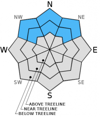
Avalanche danger remains LOW at all elevations on snow covered NW-N-NE-E aspects. Avalanche danger and snow cover are generally nonexistent on SE-S-SW-W aspects.

1. Low

?

Above Treeline
Generally safe avalanche conditions. Watch for unstable snow on isolated terrain features.

1. Low

?

Near Treeline
Generally safe avalanche conditions. Watch for unstable snow on isolated terrain features.

1. Low

?

Below Treeline
Generally safe avalanche conditions. Watch for unstable snow on isolated terrain features.
    Generally safe avalanche conditions. Watch for unstable snow on isolated terrain features.
Avalanche Problem 1: Normal Caution
  • Type ?
  • Aspect/Elevation ?
  • Likelihood ?
    Certain
    Very Likely
    Likely
    Possible
    Unlikely
  • Size ?
    Historic
    Very Large
    Large
    Small

While most data indicates that the snowpack can support itself and people recreating on top of it, a few isolated results indicating instability continue to occur. Persistent weak layers like those buried in the current snowpack often produce this kind of variability. Due to the nature of these weak layers and this variability, finding some unstable snow in the form of a small persistent slab on an isolated terrain feature on a NW-N-NE aspect is not impossible even though avalanche activity on a region scale remains unlikely. Continue to evaluate the snowpack before committing to a slope and employ safe backcountry travel practices like traveling one at a time and spotting partners from known safe zones outside of any avalanche path. Numerous rocks, trees, stumps, logs and other obstacles remain exposed and could easily injure people or break equipment.

recent observations

Yesterday observations in the Mt. Rose backcountry east of Mt. Rose Meadows resulted in data consistent with other information collected around the forecast area. A shallow snowpack comprised mostly of weak facetted snow exists on the northerly aspects and almost no snow exists on the aspects facing the southern half of the compass. In this area similar to other areas, tests indicated that the snowpack can currently support itself and people recreating on top of it, but an additional snow load could still reactivate the buried weak layers.

Weather and CURRENT CONDITIONS
weather summary

It turns out that the weak low pressure that slid in from the north and east yesterday brought more than just cooler temperatures and east winds. It did produce some snow flurries in a few areas around the region. These scattered snow showers did not yield any real accumulation only a light dusting of snow on the ground, still it was a welcome sight. As this low continues westward, the high pressure ridge will absorb it and re-establish itself as the driving weather force. In the next 24 hrs, the clouds should dissipate, the winds should decrease, and temperatures should begin to warm back up as dry, sunny, spring-like weather returns to the area.

CONDITIONS ALONG THE SIERRA CREST BETWEEN 8200 FT. AND 9200 FT. IN THE LAST 24 HOURS
6am temperature: 20 to 26 deg. F.
Max. temperature: 25 to 31 deg. F.
Average ridgetop wind direction: East
Average ridgetop wind speed: 30 to 45 mph
Maximum ridgetop wind gust: 68 mph
New snowfall: A trace to 0 inches
Total snow depth: 8 to 15 inches
Two-Day Mountain Weather Forecast Produced in partnership with the Reno NWS
For 7000 ft. to 8000 ft.
Friday Friday Night Saturday
Weather: Mostly cloudy becoming partly cloudy by the afternoon Partly cloudy Partly cloudy becoming sunny by the afternoon
Temperatures: 36 to 43 deg. F. 24 to 30 deg. F. 40 to 47 deg. F.
Mid Slope Winds: East Variable Variable
Wind Speed: 20 to 25 mph decreasing to 10 to 15 mph in the afternoon Light Light
Expected snowfall: 0 0 0
For 8000 ft. to 9000 ft.
Friday Friday Night Saturday
Weather: Mostly cloudy becoming partly cloudy by the afternoon Partly cloudy Partly cloudy becoming sunny by the afternoon
Temperatures: 33 to 40 deg. F. 22 to 29 deg. F. 37 to 44 deg. F.
Ridge Top Winds: Southeast Variable Variable
Wind Speed: 30 to 35 mph with gusts to 50 mph decreasing to 15 to 20 mph with gusts to 30 mph in the afternoon Light Light
Expected snowfall: 0 0 0
Disclaimer

This avalanche advisory is provided through a partnership between the Tahoe National Forest and the Sierra Avalanche Center. This advisory covers the Central Sierra Nevada Mountains between Yuba Pass on the north and Ebbetts Pass on the south. Click here for a map of the forecast area. This advisory applies only to backcountry areas outside established ski area boundaries. This advisory describes general avalanche conditions and local variations always occur. This advisory expires 24 hours after the posted time unless otherwise noted. The information in this advisory is provided by the USDA Forest Service who is solely responsible for its content.