THIS AVALANCHE FORECAST EXPIRED ON January 26, 2014 @ 6:50 am
Avalanche Forecast published on January 25, 2014 @ 6:50 am
Issued by Andy Anderson - Tahoe National Forest - Sierra Avalanche Center

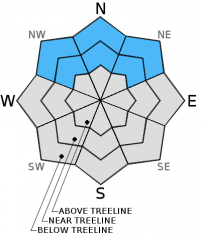
Avalanche danger remains LOW at all elevations on snow covered NW-N-NE-E aspects. Avalanche danger and snow cover are generally nonexistent on SE-S-SW-W aspects.

1. Low

?

Above Treeline
Generally safe avalanche conditions. Watch for unstable snow on isolated terrain features.

1. Low

?

Near Treeline
Generally safe avalanche conditions. Watch for unstable snow on isolated terrain features.

1. Low

?

Below Treeline
Generally safe avalanche conditions. Watch for unstable snow on isolated terrain features.
    Generally safe avalanche conditions. Watch for unstable snow on isolated terrain features.
Avalanche Problem 1: Normal Caution
  • Type ?
  • Aspect/Elevation ?
  • Likelihood ?
    Certain
    Very Likely
    Likely
    Possible
    Unlikely
  • Size ?
    Historic
    Very Large
    Large
    Small

Avalanche activity on a region scale remains unlikely. However the variability and uncertainty associated with persistent weak layers like those buried in the current snowpack means finding some unstable snow in the form of a small persistent slab on an isolated terrain feature on a NW-N-NE aspect is not impossible. Continue to evaluate the snowpack before committing to a slope and employ safe backcountry travel practices like traveling one at a time and spotting partners from known safe zones outside of any avalanche path. Numerous rocks, trees, stumps, logs, and other obstacles remain exposed and could easily injure people or break equipment.

recent observations

The snowpack continues to shrink. Yesterday on Red Lake Peak most of the snow had melted off a road that had previously provided snow covered access to elevations above 8200 ft. Above 8200 ft. in this area, snow cover still exists on the northerly aspects. The snowpack here shows characteristics similar to those seen around the region. The snowpack consists of mostly faceted weak snow. Tests on N-NE slopes between 8200 ft. and 9200 ft. in this area showed greater variation in results with some results pointing towards instability and others indicating stability. Overall, other data combined with these variable tests still indicated that the weak snowpack can currently support itself and people recreating on top of it.

Weather and CURRENT CONDITIONS
weather summary

The high pressure ridge remains in place, so expect more spring-like weather through the weekend. In the mountains above 7000 ft. temperatures could reach into the mid to upper 40's on the next two days. The winds should remain mostly calm and the skies should remain mostly clear.

CONDITIONS ALONG THE SIERRA CREST BETWEEN 8200 FT. AND 9200 FT. IN THE LAST 24 HOURS
6am temperature: 28 to 36 deg. F.
Max. temperature: 37 to 44 deg. F.
Average ridgetop wind direction: East
Average ridgetop wind speed: 5 to 10 mph
Maximum ridgetop wind gust: 40 mph
New snowfall: 0 inches
Total snow depth: 8 to 15 inches
Two-Day Mountain Weather Forecast Produced in partnership with the Reno NWS
For 7000 ft. to 8000 ft.
Saturday Saturday Night Sunday
Weather: Mostly sunny Partly cloudy Sunny then becoming partly cloudy
Temperatures: 41 to 48 deg. F. 24 to 30 deg. F. 43 to 50 deg. F.
Mid Slope Winds: Variable Variable Variable
Wind Speed: Light Light Light
Expected snowfall: 0 0 0
For 8000 ft. to 9000 ft.
Saturday Saturday Night Sunday
Weather: Mostly sunny Partly cloudy Sunny then becoming partly cloudy
Temperatures: 37 to 44 deg. F. 23 to 30 deg. F. 39 to 46 deg. F.
Ridge Top Winds: Variable Variable Variable
Wind Speed: Light Light Light
Expected snowfall: 0 0 0
Disclaimer

This avalanche advisory is provided through a partnership between the Tahoe National Forest and the Sierra Avalanche Center. This advisory covers the Central Sierra Nevada Mountains between Yuba Pass on the north and Ebbetts Pass on the south. Click here for a map of the forecast area. This advisory applies only to backcountry areas outside established ski area boundaries. This advisory describes general avalanche conditions and local variations always occur. This advisory expires 24 hours after the posted time unless otherwise noted. The information in this advisory is provided by the USDA Forest Service who is solely responsible for its content.