THIS AVALANCHE FORECAST EXPIRED ON January 27, 2014 @ 6:58 am
Avalanche Forecast published on January 26, 2014 @ 6:58 am
Issued by Brandon Schwartz - Tahoe National Forest

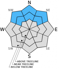
Avalanche danger remains LOW at all elevations on snow covered NW-N-NE-E aspects. Avalanche danger is generally nonexistent on SE-S-SW-W aspects due to the lack of snow cover.

1. Low

?

Above Treeline
Generally safe avalanche conditions. Watch for unstable snow on isolated terrain features.

1. Low

?

Near Treeline
Generally safe avalanche conditions. Watch for unstable snow on isolated terrain features.

1. Low

?

Below Treeline
Generally safe avalanche conditions. Watch for unstable snow on isolated terrain features.
    Generally safe avalanche conditions. Watch for unstable snow on isolated terrain features.
Avalanche Problem 1: Normal Caution
  • Type ?
  • Aspect/Elevation ?
  • Likelihood ?
    Certain
    Very Likely
    Likely
    Possible
    Unlikely
  • Size ?
    Historic
    Very Large
    Large
    Small

Avalanche activity on a region scale remains unlikely. Due to the variability associated with faceted persistent weak layers such as those buried in the current snowpack, finding a localized area of unstable snow is not impossible. If this were to occur, it would present as a small persistent slab on an isolated terrain feature located near treeline or below treeline on a NW-N-NE aspect.

For this reason, it remains prudent to evaluate the snowpack before committing to a slope. Stack the odds on survival through the use backcountry travel practices such as traveling one at a time through avalanche terrain and by spotting partners from known safe zones outside of the avalanche path. Numerous rocks, trees, stumps, logs, and other obstacles remain exposed and present an additional hazard for injury and equipment damage.

recent observations

Observations made yesterday on Billy's Peak at the head of the Deep Creek drainage revealed significant near surface faceting and buried facet layers within the snowpack. This is similar to other recent observations from around the forecast area. The snowpack that exists near treeline and below treeline on NW-N-NE aspects has shown indications that it is weak but stable at this time. Buried weak layers have generally shown the ability to support the current load of the shallow overlying snowpack, plus the weight of a person traveling on the snow surface.

With the potential for precipitation on the horizon, it is important to understand that despite the persistent drought pattern, the existing snowpack on NW-N-NE aspects is in poor condition to handle new loading from either rain or snow.

Weather and CURRENT CONDITIONS
weather summary

A change in the persistent weather pattern is in sight. High pressure will remain over the forecast area today and tomorrow. For the short term, expect continued light winds, maximum daytime air temperatures above 7,000' in the 40s, and rebuilding air temperature inversion conditions. The high pressure ridge is forecast to weaken on Tuesday, opening the door for a storm system(s) to pass through the region during the latter half of this week. There is still significant weather model uncertainty in terms of precipitation amounts. That should become more clear over the next 48 hours.

CONDITIONS ALONG THE SIERRA CREST BETWEEN 8200 FT. AND 9200 FT. IN THE LAST 24 HOURS
6am temperature: 29 to 35 deg. F.
Max. temperature: 41 to 49 deg. F.
Average ridgetop wind direction: East
Average ridgetop wind speed: 21 mph
Maximum ridgetop wind gust: 32 mph
New snowfall: 0 inches
Total snow depth: 8 to 15 inches
Two-Day Mountain Weather Forecast Produced in partnership with the Reno NWS
For 7000 ft. to 8000 ft.
Sunday Sunday Night Monday
Weather: Mostly sunny skies. Clear skies. Sunny skies, becoming partly cloudy.
Temperatures: 45 to 50 deg. F. 25 to 31 deg. F. 47 to 52 deg. F.
Mid Slope Winds: Variable Variable Variable
Wind Speed: Light winds Light winds Light winds
Expected snowfall: 0 0 0
For 8000 ft. to 9000 ft.
Sunday Sunday Night Monday
Weather: Mostly sunny skies. Clear skies. Sunny skies, becoming partly cloudy.
Temperatures: 41 to 46 deg. F. 26 to 32 deg. F. 43 to 50 deg. F.
Ridge Top Winds: East East East shifting to Northwest in the afternoon.
Wind Speed: Light winds Light winds Light winds increasing to 10 to 15 mph in the afternoon.
Expected snowfall: 0 0 0
Disclaimer

This avalanche advisory is provided through a partnership between the Tahoe National Forest and the Sierra Avalanche Center. This advisory covers the Central Sierra Nevada Mountains between Yuba Pass on the north and Ebbetts Pass on the south. Click here for a map of the forecast area. This advisory applies only to backcountry areas outside established ski area boundaries. This advisory describes general avalanche conditions and local variations always occur. This advisory expires 24 hours after the posted time unless otherwise noted. The information in this advisory is provided by the USDA Forest Service who is solely responsible for its content.