THIS AVALANCHE FORECAST EXPIRED ON January 28, 2014 @ 6:50 am
Avalanche Forecast published on January 27, 2014 @ 6:50 am
Issued by Brandon Schwartz - Tahoe National Forest

An increase in avalanche danger my occur tonight into tomorrow. For today avalanche danger remains LOW at all elevations on snow covered NW-N-NE-E aspects. Avalanche danger is generally nonexistent on SE-S-SW-W aspects due to the lack of snow cover. The possibility of rain on snow tonight has the potential to increase avalanche danger. Depending on how much rain reaches the ground, natural wet loose snow avalanches could occur late tonight and early tomorrow morning.

1. Low

?

Above Treeline
Generally safe avalanche conditions. Watch for unstable snow on isolated terrain features.

1. Low

?

Near Treeline
Generally safe avalanche conditions. Watch for unstable snow on isolated terrain features.

1. Low

?

Below Treeline
Generally safe avalanche conditions. Watch for unstable snow on isolated terrain features.
    Generally safe avalanche conditions. Watch for unstable snow on isolated terrain features.
Avalanche Problem 1: Normal Caution
  • Type ?
  • Aspect/Elevation ?
  • Likelihood ?
    Certain
    Very Likely
    Likely
    Possible
    Unlikely
  • Size ?
    Historic
    Very Large
    Large
    Small

During the daylight hours today, avalanche activity on a region scale remains unlikely. Due to the variability associated with faceted persistent weak layers such as those buried in the current snowpack, finding a localized area of unstable snow is not impossible. If this were to occur, it would present as a small persistent slab on an isolated terrain feature located near treeline or below treeline on a NW-N-NE aspect.

For this reason, it remains prudent to evaluate the snowpack before committing to a slope. Stack the odds on survival through the use of backcountry travel practices such as traveling one at a time through avalanche terrain and by spotting partners from known safe zones outside of the avalanche path. Numerous rocks, trees, stumps, logs, and other obstacles remain exposed and present an additional hazard for injury and equipment damage.

Avalanche Problem 2: Loose Wet
  • Type ?
  • Aspect/Elevation ?
  • Likelihood ?
    Certain
    Very Likely
    Likely
    Possible
    Unlikely
  • Size ?
    Historic
    Very Large
    Large
    Small

After precipitation arrives tonight, the possibility of naturally occurring wet loose snow avalanches will increase. Locations where rain falls on well developed near surface facets are the expected problem areas. NW-N-NE aspects between 7,000' and 8,000' is where this avalanche problem is most likely to occur. Some isolated E aspects may become involved as well. Steeper slope angles upwards of 37 degrees may be necessary for avalanche activity to initiate.

recent observations

Observations made yesterday on Lincoln Ridge (Yuba Pass area) showed a continuation of the area wide snowpack trend of significant near surface faceting and buried facet layers within the snowpack. The snowpack that exists near treeline and below treeline on NW-N-NE aspects has shown indications that it is weak but stable at this time. Buried weak layers have generally shown the ability to support the current load of the shallow overlying snowpack, plus the weight of a person traveling on the snow surface.

With the potential for precipitation on the horizon, it is important to understand that despite the persistent drought pattern, the existing snowpack on NW-N-NE aspects is in poor condition to handle new loading from either rain or snow. Once significant precipitation is added, the existing snowpack is likely to rapidly change from stable to unstable.

Weather and CURRENT CONDITIONS
weather summary

The ridge of high pressure that has kept the weather warm and dry for nearly all of the past seven weeks is finally breaking down. A series of storm systems will move into the region this week. The first system expected to arrive tonight into tomorrow morning will weaken significantly as it interacts the with high pressure ridge. Light rain up to 8,000' is forecast for tonight and tomorrow. Dry air at the lower elevations may initially allow for much lower snow levels or limit how much precipitation reaches the ground below 7,000'. Precipitation totals from this first system are minimal with up to 0.1 inch of rain or up to 1 inch of snow forecast. The big news is that this system will open the door for a stronger storm system to move into the area Wednesday into Thursday.

CONDITIONS ALONG THE SIERRA CREST BETWEEN 8200 FT. AND 9200 FT. IN THE LAST 24 HOURS
6am temperature: 32 to 39 deg. F.
Max. temperature: 40 to 46 deg. F.
Average ridgetop wind direction: East
Average ridgetop wind speed: 14 mph
Maximum ridgetop wind gust: 31 mph
New snowfall: 0 inches
Total snow depth: 8 to 15 inches
Two-Day Mountain Weather Forecast Produced in partnership with the Reno NWS
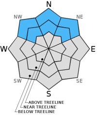
For 7000 ft. to 8000 ft.
Monday Monday Night Tuesday
Weather: Partly cloudy skies. Mostly cloudy skies. A slight chance of rain and snow after midnight. Cloudy skies with a slight chance of rain and snow in the morning.
Temperatures: 43 to 50 deg. F. 27 to 33 deg. F. 43 to 50 deg. F.
Mid Slope Winds: Southwest Southwest West
Wind Speed: Light winds Light winds increasing to 10 to 15 mph after midnight. 15 to 20 mph with gusts to 30 mph.
Expected snowfall: 0 0 to 1 0 to 1
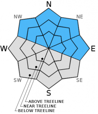
For 8000 ft. to 9000 ft.
Monday Monday Night Tuesday
Weather: Partly cloudy skies. Mostly cloudy skies. A slight chance of rain and snow after midnight. Cloudy skies with a slight chance of rain and snow in the morning.
Temperatures: 43 to 49 deg. F. 25 to 32 deg. F. 44 to 50 deg. F.
Ridge Top Winds: Southwest West West
Wind Speed: Light winds increasing to 10 to 15 mph in the afternoon. 15 to 20 mph. Gusts up to 35 mph after midnight. 20 to 25 mph with gusts to 40 mph, increasing to 30 to 35 mph with gusts to 50 mph in the aftenoon.
Expected snowfall: 0 0 to 1 0 to 1
Disclaimer

This avalanche advisory is provided through a partnership between the Tahoe National Forest and the Sierra Avalanche Center. This advisory covers the Central Sierra Nevada Mountains between Yuba Pass on the north and Ebbetts Pass on the south. Click here for a map of the forecast area. This advisory applies only to backcountry areas outside established ski area boundaries. This advisory describes general avalanche conditions and local variations always occur. This advisory expires 24 hours after the posted time unless otherwise noted. The information in this advisory is provided by the USDA Forest Service who is solely responsible for its content.