THIS AVALANCHE FORECAST EXPIRED ON January 30, 2014 @ 7:00 am
Avalanche Forecast published on January 29, 2014 @ 7:00 am
Issued by Andy Anderson - Tahoe National Forest - Sierra Avalanche Center

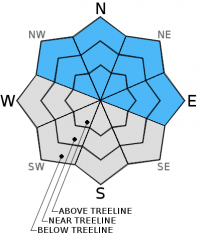
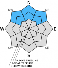
Avalanche danger remains LOW for most areas today. In areas where rain falls on the snowpack, pockets of MODERATE danger could form on NW-N-NE-E aspects on slopes steeper than 37 degrees due to the possibility of loose wet avalanches.

The avalanche danger will increase tonight and tomorrow as a strong winter storm brings wind, some rain, and 1-2 ft of snow above 7000 ft. The new load on top of the already weak snowpack should cause the avalanche danger to reach HIGH meaning that natural and human triggered avalanches will become very likely tonight and tomorrow. Travel in and around avalanche terrain is not recommended tonight or during the day tomorrow.

1. Low

?

Above Treeline
Generally safe avalanche conditions. Watch for unstable snow on isolated terrain features.

2. Moderate

?

Near Treeline
Heightened avalanche conditions on specific terrain features. Evaluate snow and terrain carefully; identify features of concern.

2. Moderate

?

Below Treeline
Heightened avalanche conditions on specific terrain features. Evaluate snow and terrain carefully; identify features of concern.
    Heightened avalanche conditions on specific terrain features. Evaluate snow and terrain carefully; identify features of concern.
Avalanche Problem 1: Loose Wet
  • Type ?
  • Aspect/Elevation ?
  • Likelihood ?
    Certain
    Very Likely
    Likely
    Possible
    Unlikely
  • Size ?
    Historic
    Very Large
    Large
    Small

Natural and human triggered wet loose avalanches could become possible again today in places where where light rain falls on the snowpack. Near and below treeline NW-N-NE aspects below 8,000 to 9,500' that already hold wet snow and areas where water saturates some of the near surface facet layers will hold the greatest potential for these wet loose slides. Still these wet snow problems could occur on any snow covered slope that receives rain today. Steeper slope angles upwards of 37 degrees may be necessary for avalanches to initiate.

Avalanche Problem 2: Persistent Slab
  • Type ?
  • Aspect/Elevation ?
  • Likelihood ?
    Certain
    Very Likely
    Likely
    Possible
    Unlikely
  • Size ?
    Historic
    Very Large
    Large
    Small

During the day today persistent slabs avalanches should remain unlikely since there is not much new load above them. However, as new snow and wind impact the forecast area tonight and tomorrow, this avalanche problem will become a serious threat. For the last several weeks the snowpack has gotten weaker and weaker and the only ingredient missing from the avalanche recipe has been a thick cohesive slab layer. This storm will provide that slab layer in the form of 1-2 ft. of dense storm slabs and wind slabs. Data indicates that the current snowpack will not support this load. Natural and human triggered avalanches will become very likely overnight and tomorrow. The size and extent of these avalanches will also increase as the snow accumulates. This is an unusual winter with a snowpack more like a CO pack than a Tahoe pack. Don't let old habits or "powder-fever" dictate decisions tomorrow. 

recent observations

Yesterday observations on Andesite Peak, near Emerald Bay, and at Mt. Rose, all showed wet unconsolidated snow on the surface. In all three of these areas small wet loose slides involving this surface snow occurred (see photos below). On Andesite Peak and at Mt. Rose below the wet surface snow, the snowpack still consists of several layers of very weak facetted snow. Tests and data indicated that the snowpack in both these places would not support the new snow load expected to arrive over the next 36 hours. All across the forecast area data and observations have shown similar weakness where ever snow exists.

Weather and CURRENT CONDITIONS
weather summary

The southwest winds have started to increase ahead of a strong storm system approaching the area. Expect clouds and winds to continue increasing today as the storm moves closer. By the afternoon, some precipitation could start to fall. Due to warm air over the region, snow levels today should remain around 8000 ft. As the storm moves further inland tonight, colder air should also move into the area causing snow levels to fall below Lake Level (6500 ft.) overnight. Snow levels should continue to drop to around 5000-5500 ft. during the day tomorrow. Once the precipitation starts this afternoon, it should continue through Thursday evening. The forecast calls for 1-2 ft of  snow accumulation above 7000 ft. by the end of the day tomorrow. In areas above 8000 ft, more than 2 ft of snow could accumulate. Below 7000 ft. more of the precipitation will fall as rain, but 5-10 inches of new snow could still accumulate. Check out the weather briefing published by the Reno NWS on Jan. 28th at 2:30 pm for information. For the latest details on this storm check the Reno NWS website.

CONDITIONS ALONG THE SIERRA CREST BETWEEN 8200 FT. AND 9200 FT. IN THE LAST 24 HOURS
6am temperature: 37 to 41 deg. F.
Max. temperature: 42 to 46 deg. F.
Average ridgetop wind direction: West Southwest
Average ridgetop wind speed: 15 to 25 mph
Maximum ridgetop wind gust: 40 mph
New snowfall: Rain: trace to 0 inches
Total snow depth: 7 to 14 inches
Two-Day Mountain Weather Forecast Produced in partnership with the Reno NWS
For 7000 ft. to 8000 ft.
Wednesday Wednesday Night Thursday
Weather: Mostly cloudy with a chance of rain this afternoon. Rain turning to snow overnight Snow
Temperatures: 45 to 51 deg. F. 24 to 31 deg. F. 25 to 32 deg. F.
Mid Slope Winds: Southwest Southwest Southwest
Wind Speed: 20 to 30 mph with gusts to 45 mph 25 to 35 mph with gusts to 50 mph 15 to 25 mph with gusts to 35 mph
Expected snowfall: 0 4 to 8 6 to 12
For 8000 ft. to 9000 ft.
Wednesday Wednesday Night Thursday
Weather: Mostly cloudy with a chance of rain or snow this afternoon. Rain turning to snow overnight Snow
Temperatures: 40 to 46 deg. F. 22 to 29 deg. F. 22 to 29 deg. F.
Ridge Top Winds: Southwest Southwest Southwest
Wind Speed: 35 to 45 mph with gusts to 60 mph increasing to gusts to 70 mph in the afternoon 40 to 50 mph with gusts to 80 mph 30 to 35 mph with gusts to 60 mph decreasing to 20 to 25 mph with gusts to 40 mph in the afternoon
Expected snowfall: 0 6 to 12 6 to 12
Disclaimer

This avalanche advisory is provided through a partnership between the Tahoe National Forest and the Sierra Avalanche Center. This advisory covers the Central Sierra Nevada Mountains between Yuba Pass on the north and Ebbetts Pass on the south. Click here for a map of the forecast area. This advisory applies only to backcountry areas outside established ski area boundaries. This advisory describes general avalanche conditions and local variations always occur. This advisory expires 24 hours after the posted time unless otherwise noted. The information in this advisory is provided by the USDA Forest Service who is solely responsible for its content.