THIS AVALANCHE FORECAST EXPIRED ON January 31, 2014 @ 7:00 am
Avalanche Forecast published on January 30, 2014 @ 7:00 am
Issued by Andy Anderson - Tahoe National Forest - Sierra Avalanche Center

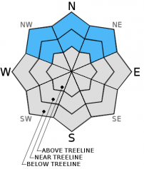
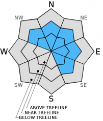
HIGH avalanche danger exists on slopes steeper than 30 degrees in near and below treeline terrain on NW-N-NE aspects due to new heavy snow slabs sitting on top of persistent weak layers. Natural and human triggered avalanche are very likely on these slopes today. CONSIDERABLE avalanche danger exists on the wind loaded NW-N-NE-E-SE aspects in near and above treeline terrain due to the pressence of newly formed wind slabs on slopes 35 degrees and steeper. MODERATE avalanche danger exists on all other aspects.

Travel in, around, or near avalanche terrain is not recommended today.

3. Considerable

?

Above Treeline
Dangerous avalanche conditions. Careful snowpack evaluation, cautious route-finding and conservative decision-making essential.

4. High

?

Near Treeline
Very dangerous avalanche conditions. Travel in avalanche terrain not recommended.

4. High

?

Below Treeline
Very dangerous avalanche conditions. Travel in avalanche terrain not recommended.
    Very dangerous avalanche conditions. Travel in avalanche terrain not recommended.
Avalanche Problem 1: Persistent Slab
  • Type ?
  • Aspect/Elevation ?
  • Likelihood ?
    Certain
    Very Likely
    Likely
    Possible
    Unlikely
  • Size ?
    Historic
    Very Large
    Large
    Small

Natural and human triggered persistent slab avalanches are very likely today on near and below treeline NW-N-NE aspects. New slabs made of heavy snow that has fallen since yesterday now exist on top of a snowpack that consists of several persistent weak layers on these aspects. The snowpack could barely support itself before the new load arrived. As more snow falls today the slabs will grow in size and extent. Heavy slabs on top of persistent weak layers create very serious avalanche conditions. These kind of avalanches can be triggered from a distance or from "safe" slopes connected to steeper terrain. These avalanches could involve the entire snowpack. These conditions look more like a typical Colorado snowpack than a Tahoe snowpack. Don't let habits and familiarity or "powder-fever" dictate decisions today. These unusual conditions require extra caution and superb travel skills. Travel in, around, or near avalanche terrain is not recommended today.

Avalanche Problem 2: Wind Slab
  • Type ?
  • Aspect/Elevation ?
  • Likelihood ?
    Certain
    Very Likely
    Likely
    Possible
    Unlikely
  • Size ?
    Historic
    Very Large
    Large
    Small

New snow and strong winds have created wind slabs on the near and above treeline NW-N-NE-E-SE aspects. As snow and wind continue today these slabs will increase in size and extent. Human triggered avalanches involving these wind slabs are likely and natural avalanches are possible. On the NW-N-NE aspects where these slabs exist above the old persistent weak layers natural and human triggered avalanches are very likely, and they will behave more like the persistent slabs discussed above.

recent observations

Yesterday near Red Lake on Carson Pass, snow level hovered around 8400 ft. for most of the day. Due to the steady rain, free water had penetrated to the bottom of the shallow snowpack. In this area yesterday, the snowpack consisted of several layers of wet, weak, unconsolidated facets. The snowpack could not even support a person on skis and each time I weighted my skis I sank to the ground. Some skier triggered cracking started to occur on N-NE aspects yesterday afternoon as the snowpack weakened. Snowpit tests confirmed this weakening with all results indicating a snowpack that could barely hold itself up and some results showing that fractures could travel through the buried persistent weak layers.

Weather and CURRENT CONDITIONS
weather summary

Precipitation started as rain across the forecast area with snow levels hovering between 8000 ft. and 8500 ft. until yesterday evening. Overnight the precipitation intensity increased and snow levels started to fall. Overall 1.5 to 2.25 inches of water has fallen during this storm: mostly as rain below 7000 ft. since snow levels did not fall below 7000 ft. until after 1am. The mountains above 7500 ft. received 6 to 12 inches of new snow overnight. The lower elevations only picked up 2 to 4 inches of snow overnight. Heavy snowfall should continue through midday before turning to snow showers and decreasing this afternoon. The forecast calls for another 4 to 8 inches of new snow above 7000 ft. today with the heaviest precipitation falling from Hwy 50 south. The strong SW winds that started yesterday should persist through today before starting to slowly decrease overnight. After a lull in storminess this afternoon, another weaker storm should impact the region overnight bringing light snow showers and 1 to 4 addition inches of snow. Temperatures should continue to cool for the next 24 hours with today's highs in the mid 20's and overnight lows around 10. By tomorrow skies should begin to clear, temperature should start to warm, and the winds should decrease and shift towards the northwest as another high pressure ridge starts to build over the area. 

CONDITIONS ALONG THE SIERRA CREST BETWEEN 8200 FT. AND 9200 FT. IN THE LAST 24 HOURS
6am temperature: 22 to 32 deg. F.
Max. temperature: 36 to 41 deg. F.
Average ridgetop wind direction: Southwest
Average ridgetop wind speed: 20-40 mph
Maximum ridgetop wind gust: 82 mph
New snowfall: Rain: .6 inches | Snow: 6 to 12 inches
Total snow depth: 13 to 24 inches
Two-Day Mountain Weather Forecast Produced in partnership with the Reno NWS
For 7000 ft. to 8000 ft.
Thursday Thursday Night Friday
Weather: Snow in the morning becoming snow showers in the afternoon Snow showers Mostly cloudy with a 40% chance of snow showers
Temperatures: 22 to 29 deg. F. 10 to 17 deg. F. 25 to 53 deg. F.
Mid Slope Winds: West West Northwest
Wind Speed: 15 to 25 mph with gusts to 40 mph decreasing to gusts to 30 mph in the afternoon 15 to 20 mph with gusts to 30 mph 10 to 15 mph with gusts to 25 mph
Expected snowfall: 4 to 6 1 to 3 0
For 8000 ft. to 9000 ft.
Thursday Thursday Night Friday
Weather: Snow in the morning becoming snow showers in the afternoon Snow showers Mostly cloudy with a 40% chance of snow showers
Temperatures: 18 to 25 deg. F. 6 to 13 deg. F. 21 to 29 deg. F.
Ridge Top Winds: Southwest West Northwest
Wind Speed: 40 to 45 mph with gusts to 65 mph decreasing to 20 to 25 mph with gusts to 40 mph in the afternoon 25 to 35 mph with gusts to 55 mph decreasing to gusts to 45 mph after midnight 15 to 25 mph with gusts to 40 mph decreasing to gusts to 30 mph in the afternoon
Expected snowfall: 4 to 8 1 to 3 0
Disclaimer

This avalanche advisory is provided through a partnership between the Tahoe National Forest and the Sierra Avalanche Center. This advisory covers the Central Sierra Nevada Mountains between Yuba Pass on the north and Ebbetts Pass on the south. Click here for a map of the forecast area. This advisory applies only to backcountry areas outside established ski area boundaries. This advisory describes general avalanche conditions and local variations always occur. This advisory expires 24 hours after the posted time unless otherwise noted. The information in this advisory is provided by the USDA Forest Service who is solely responsible for its content.