THIS AVALANCHE FORECAST EXPIRED ON February 2, 2014 @ 6:57 am
Avalanche Forecast published on February 1, 2014 @ 6:57 am
Issued by Brandon Schwartz - Tahoe National Forest

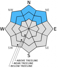
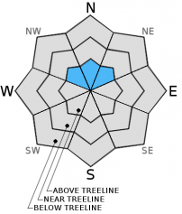
Pockets of MODERATE avalanche danger exist at all elevations on NW-N-NE aspects on slope steeper than 32 degrees that held snowcover prior to the recent snowfall. For all other areas, avalanche danger is LOW. Persistent slabs and wet slabs remain an ongoing avalanche concern.

2. Moderate

?

Above Treeline
Heightened avalanche conditions on specific terrain features. Evaluate snow and terrain carefully; identify features of concern.

2. Moderate

?

Near Treeline
Heightened avalanche conditions on specific terrain features. Evaluate snow and terrain carefully; identify features of concern.

2. Moderate

?

Below Treeline
Heightened avalanche conditions on specific terrain features. Evaluate snow and terrain carefully; identify features of concern.
    Heightened avalanche conditions on specific terrain features. Evaluate snow and terrain carefully; identify features of concern.
Avalanche Problem 1: Wet Slab
  • Type ?
  • Aspect/Elevation ?
  • Likelihood ?
    Certain
    Very Likely
    Likely
    Possible
    Unlikely
  • Size ?
    Historic
    Very Large
    Large
    Small

Wet slab avalanches remain possible today in near treeline and below treeline terrain on NW-N-NE aspects up to around 9,800'. Weak layers of wet faceted snow located below the old/new snow interface continue to show the ability to allow fractures to propagate in some areas. The potential for increasing avalanche size increases in relation to elevation as depth of both new and old snow increases. The thickest overlying slabs of new snow exist at the higher elevations. As wet faceted snow continues to refreeze, danger associated with this avalanche problem will continue to decrease.

Avalanche Problem 2: Persistent Slab
  • Type ?
  • Aspect/Elevation ?
  • Likelihood ?
    Certain
    Very Likely
    Likely
    Possible
    Unlikely
  • Size ?
    Historic
    Very Large
    Large
    Small

In areas above 9,500' to 9,800', rain did not percolate full depth through the faceted old snow layers. Persistent slab avalanches remain possible on slopes that represent the highest elevation near treeline and below treeline terrain within the forecast area. In these areas, weak layers of well developed facets and depth hoar remain problematic. Danger associated with this avalanche problem will decrease at a slower rate than the wet slab problem mentioned above.

Avalanche Problem 3: Wind Slab
  • Type ?
  • Aspect/Elevation ?
  • Likelihood ?
    Certain
    Very Likely
    Likely
    Possible
    Unlikely
  • Size ?
    Historic
    Very Large
    Large
    Small

Lingering wind slabs may remain unstable on NW-N-NE aspect above treeline terrain and along sparsely treed ridgelines. Medium size slabs will exist at higher elevations where greater amounts of new snow accumulation occurred.

recent observations

Observations made yesterday on Mt. Judah and Castle Peak in the Donner Summit area and on Mount Rose proper indicated that the snowpack is continuing to slowly gain strength following the recent rain and snow event. Evidence of rainfall from January 29 is visible in the snowpack up to a little over 10,000' on Mount Rose. In locations observed over the past two days, rain appears to have percolated full depth through the old snow layers up to an elevation of around 9,500' to 9,800'. Rain wet layers are in the process of draining and refreezing. It will likely take a few more days for full refreeze of rain wetted layers to occur.

Yesterday while ascending Mount Rose, two skier triggered collapses with audible whumphing sounds occurred in below treeline terrain on an NE aspect between 9,000' and 9,300'. The failure layer was wet facets below the new snow. In other areas yesterday, snowpit tests from each of the observed locations produced variable results on wet facets below 9,000' and on dry facets above 9,900'. Indications that human triggered avalanches could occur ranged from unlikely to likely.

Weather and CURRENT CONDITIONS
weather summary

Sunny skies and below average air temperatures are forecast for today as a break occurs between weather systems. Maximum daytime air temperatures are expected to reach the 20s to low 30s today for areas above 7,000'. High level cloud cover will increase tonight as a low pressure system approaches the north coast. Light snow showers are possible tomorrow afternoon with less than 1 inch of new snow accumulation expected. Light winds are forecast for today and tomorrow.

CONDITIONS ALONG THE SIERRA CREST BETWEEN 8200 FT. AND 9200 FT. IN THE LAST 24 HOURS
6am temperature: 9 to 16 deg. F.
Max. temperature: 24 to 32 deg. F.
Average ridgetop wind direction: East
Average ridgetop wind speed: 21 mph
Maximum ridgetop wind gust: 37 mph
New snowfall: 0 to trace inches
Total snow depth: 15 to 33 inches
Two-Day Mountain Weather Forecast Produced in partnership with the Reno NWS
For 7000 ft. to 8000 ft.
Saturday Saturday Night Sunday
Weather: Sunny skies. Partly cloudy skies, becoming mostly cloudy. Mostly cloudy skies with a slight chance of snow showers in the afternoon.
Temperatures: 26 to 32 deg. F. 13 to 19 deg. F. 22 to 29 deg. F.
Mid Slope Winds: Variable Variable Variable
Wind Speed: Light winds Light winds Light winds
Expected snowfall: 0 0 0 to trace
For 8000 ft. to 9000 ft.
Saturday Saturday Night Sunday
Weather: Sunny skies. Partly cloudy skies, becoming mostly cloudy. Mostly cloudy skies with a slight chance of snow showers in the afternoon.
Temperatures: 20 to 28 deg. F. 10 to 16 deg. F. 17 to 24 deg. F.
Ridge Top Winds: Variable Variable Variable
Wind Speed: Light winds Light winds Light winds
Expected snowfall: 0 0 0 to trace
Disclaimer

This avalanche advisory is provided through a partnership between the Tahoe National Forest and the Sierra Avalanche Center. This advisory covers the Central Sierra Nevada Mountains between Yuba Pass on the north and Ebbetts Pass on the south. Click here for a map of the forecast area. This advisory applies only to backcountry areas outside established ski area boundaries. This advisory describes general avalanche conditions and local variations always occur. This advisory expires 24 hours after the posted time unless otherwise noted. The information in this advisory is provided by the USDA Forest Service who is solely responsible for its content.