THIS AVALANCHE FORECAST EXPIRED ON February 4, 2014 @ 6:36 am
Avalanche Forecast published on February 3, 2014 @ 6:36 am
Issued by Brandon Schwartz - Tahoe National Forest

Avalanche danger is LOW for all elevations and aspects. Keep in mind that the definition of LOW danger states that human triggered avalanches are unlikely on a regional scale but could still occur in isolated areas or extreme terrain.

1. Low

?

Above Treeline
Generally safe avalanche conditions. Watch for unstable snow on isolated terrain features.

1. Low

?

Near Treeline
Generally safe avalanche conditions. Watch for unstable snow on isolated terrain features.

1. Low

?

Below Treeline
Generally safe avalanche conditions. Watch for unstable snow on isolated terrain features.
    Generally safe avalanche conditions. Watch for unstable snow on isolated terrain features.
Avalanche Problem 1: Wind Slab
  • Type ?
  • Aspect/Elevation ?
  • Likelihood ?
    Certain
    Very Likely
    Likely
    Possible
    Unlikely
  • Size ?
    Historic
    Very Large
    Large
    Small

Winds have shifted back and forth several time between east and southwest/west over the past 48 hours. Areas of blowing snow have been visible above treeline at times. Recently formed wind slabs could exist on a variety of aspects above treeline and along sparsely treed ridgelines. These wind slab are likely small in size, but in isolated areas could approach 1 foot in depth.

Avalanche Problem 2: Persistent Slab
  • Type ?
  • Aspect/Elevation ?
  • Likelihood ?
    Certain
    Very Likely
    Likely
    Possible
    Unlikely
  • Size ?
    Historic
    Very Large
    Large
    Small

In areas above 9,500' to 9,800', rain did not percolate full depth through the faceted old snow layers on near treeline and below treeline NW-N-NE aspects. In these upper elevation areas, problematic facet layers were not destroyed by the rain that fell in areas of relative lower elevation. Human triggered persistent slab avalanches are not impossible on slopes that represent the highest elevation near treeline and below treeline terrain within the forecast area. In these areas, weak layers of well developed facets and depth hoar exist below the overlying slab of recent new snow.

recent observations

Observations made yesterday on Rubicon Peak (West Shore Tahoe area) revealed that small grains of surface hoar were buried under yesterday's snowfall. This is not a problem today, but holds the potential to become a significant weak layer in the future. The overall snowpack continues to show evidence of strength gain following the end of the last storm cycle. A very strong temperature gradient has been observed within the snowpack and very early stage near crust facets were noted on top of the rain crust on Rubicon Peak. At the time of observation, bonding of recent new snow to the rain crust below remained strong.

Things to keep an eye on: 1) Formation of a new weak layer of near crust facets on top of the rain crust, just below the overlying slab of recent new snow. 2) Location and extent of areas of surface hoar now buried under yesterdays snowfall.

If the near crust facet layer continues to form, this metamorphosis of snow crystals on the ground could create a new weak layer within the snowpack. If this were to occur, snowpack stability could begin to increase rather than continue to decrease. Slopes that were stable this past weekend could become unstable over the coming days. If the areas of surface hoar that were buried yesterday are sizable, a problematic weak layer could be in place for later snow storms, potentially at the end of this week. As you stop from time to time, scoop up the top few inches of snow and gently shake it in the palm of your hand. If you see triangular shaped, striated snow crystals mixed in with the new snow, you are in an area with buried surface hoar. Good to know for future visits.

Weather and CURRENT CONDITIONS
weather summary

Yesterday's snow showers allowed for 2 to 4 inches of new snow to accumulate above 7,000'. Today will see mostly cloudy skies with isolated snow showers this afternoon and evening as a cold front moves through the region. The weather pattern creating snow showers this afternoon is different than the pattern from yesterday, making another period of prolonged snow showers unlikely. Only a trace of new snow accumulation is expected this afternoon through this evening. Ridgetop winds have shifted back and forth from southwest to east to west over the past 24 hours. Winds remain out of the west this morning. Winds speeds over the past 24 hours have ranged from light to moderate. Air temperatures are forecast to remain below average this week. Maximum daytime air temperatures are expected to reach the teens to upper 20s today for areas above 7,000'.

CONDITIONS ALONG THE SIERRA CREST BETWEEN 8200 FT. AND 9200 FT. IN THE LAST 24 HOURS
6am temperature: 14 to 19 deg. F.
Max. temperature: 22 to 28 deg. F.
Average ridgetop wind direction: variable east and west
Average ridgetop wind speed: 12 mph
Maximum ridgetop wind gust: 35 mph
New snowfall: 2 to 5 inches
Total snow depth: 16 to 34 inches
Two-Day Mountain Weather Forecast Produced in partnership with the Reno NWS
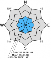
For 7000 ft. to 8000 ft.
Monday Monday Night Tuesday
Weather: Mostly cloudy skies with isolated snow showers in the afternoon. Mostly cloudy skies with isolated snow showers in the evening. Partly cloudy skies.
Temperatures: 22 to 30 deg. F. 9 to 15 deg. F. 24 to 32 deg. F.
Mid Slope Winds: West West West
Wind Speed: Light winds increasing to 10 to 15 mph in the afternoon. 10 to 15 mph in the evening, becoming light. Light winds
Expected snowfall: Trace Trace 0
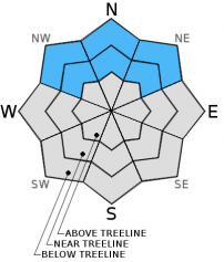
For 8000 ft. to 9000 ft.
Monday Monday Night Tuesday
Weather: Mostly cloudy skies with isolated snow showers in the afternoon. Mostly cloudy skies with isolated snow showers in the evening. Partly cloudy skies.
Temperatures: 16 to 23 deg. F. 2 to 12 deg. F. 20 to 26 deg. F.
Ridge Top Winds: West West West
Wind Speed: 15 to 20 mph with gusts to 30 mph. 15 to 25 mph with gusts to 35 mph. 15 to 20 mph. Gusts up to 30 mph in the morning.
Expected snowfall: Trace Trace 0
Disclaimer

This avalanche advisory is provided through a partnership between the Tahoe National Forest and the Sierra Avalanche Center. This advisory covers the Central Sierra Nevada Mountains between Yuba Pass on the north and Ebbetts Pass on the south. Click here for a map of the forecast area. This advisory applies only to backcountry areas outside established ski area boundaries. This advisory describes general avalanche conditions and local variations always occur. This advisory expires 24 hours after the posted time unless otherwise noted. The information in this advisory is provided by the USDA Forest Service who is solely responsible for its content.