THIS AVALANCHE FORECAST EXPIRED ON February 5, 2014 @ 7:00 am
Avalanche Forecast published on February 4, 2014 @ 7:00 am
Issued by Andy Anderson - Tahoe National Forest - Sierra Avalanche Center

The avalanche danger remains LOW at all elevations and on all aspects. Even though avalanches have become unlikely on a regional scale some unstable snow could still lurk on small isolated terrain features or in extreme terrain.

1. Low

?

Above Treeline
Generally safe avalanche conditions. Watch for unstable snow on isolated terrain features.

1. Low

?

Near Treeline
Generally safe avalanche conditions. Watch for unstable snow on isolated terrain features.

1. Low

?

Below Treeline
Generally safe avalanche conditions. Watch for unstable snow on isolated terrain features.
    Generally safe avalanche conditions. Watch for unstable snow on isolated terrain features.
Avalanche Problem 1: Normal Caution
  • Type ?
  • Aspect/Elevation ?
  • Likelihood ?
    Certain
    Very Likely
    Likely
    Possible
    Unlikely
  • Size ?
    Historic
    Very Large
    Large
    Small

A mostly strong refrozen lower snowpack with 6 to 14 inches of light, soft, unconsolidated snow as the top layer means that human triggered avalanches remain unlikely in most places today. Two potential problems have started to take shape in that light, soft snow:

  1. A buried surface hoar layer now exists in the upper few inches of the snowpack in some areas.
  2. The snow above the rain crust has started to weaken and facet.

If and when more snow accumulates on top of the current snowpack, either of these issues could cause problems. For now keeping track of where these layers exist and how they are changing will help determine which slopes may pose future problems (see the recent observations section for more details).

Avalanche Problem 2: Persistent Slab
  • Type ?
  • Aspect/Elevation ?
  • Likelihood ?
    Certain
    Very Likely
    Likely
    Possible
    Unlikely
  • Size ?
    Historic
    Very Large
    Large
    Small

In areas above 9,500 to 9,800 ft, rain did not percolate all the way through the old facetted snow layers on near treeline and below treeline NW-N-NE aspects. In these upper elevation areas, human triggered persistent slab avalanches are not impossible. Weak layers of well developed facets and depth hoar exist below the overlying slab of recent snow in these areas. Since there are very few areas with terrain above this elevation where these conditions exist in the forecast area this problem remains isolated in distribution.

Avalanche Problem 3: Wind Slab
  • Type ?
  • Aspect/Elevation ?
  • Likelihood ?
    Certain
    Very Likely
    Likely
    Possible
    Unlikely
  • Size ?
    Historic
    Very Large
    Large
    Small

Small wind slabs created by the light to moderate west and southwest winds moving the light, soft surface snow to leeward aspects represent another possibility for an isolated and unlikely but not impossible avalanche problem. These wind slabs could exist on a variety of aspects above treeline and along sparsely treed ridgelines. These wind slabs should remain small in size but could reach up to 1 ft. in depth in isolated areas.

recent observations

Yesterday on Silver Peak 6 to 12 inches of soft, cold, unconsolidated snow existed above a thick, frozen rain crust. A buried layer of surface hoar remained intact within the upper part of this soft snow.

Surface hoar represents one of the weakest kinds of snow grains. While it often forms during the calm, clear, cold nights here in Tahoe, it rarely gets buried. This time Sunday's light snowfall buried this widespread layer of surface hoar under 2-4 inches of light, soft snow. Currently, it does not pose a problem because no slab layers exist above it. For now keeping track of where the surface hoar layer exists can help determine which slopes may pose future problems. While traveling in the backcountry, stop and dig into the snow from time to time. Sift the top few inches of snow through your hands. If you see any triangular shaped, striated snow grains, a shallowly buried surface hoar layer exists in that area.

Data from Silver Peak also showed that the layer of soft snow above the rain crust had started to weaken. Like the surface hoar layer it does not currently pose a problem due to the fact that no slabs exist above this soft snow.

Below the rain crust, a thick layer of refrozen snow existed in the snowpack on Silver Peak. The frozen rain crust and the refrozen layers below have become very strong and supportable. Near the bottom of the snowpack on Silver Peak, a moist layer of unconsolidated snow still existed. This layer remained weak but should gain some strength as it continues to slowly refreeze. Yesterday the strong frozen layers above it prevented all but the largest impacts on the surface from transmitting force down to those still wet and soft layers.

Weather and CURRENT CONDITIONS
weather summary

Unsettled cold but dry weather should prevail over the forecast area through tomorrow. Winds should remain light to moderate out of the west and temperatures should only reach into the 20's above 7000 ft. today and tomorrow. Some weak low pressure systems passing near the area should keep sending a few clouds into the region during the next 36 hours. By tomorrow evening a slightly stronger low pressure may push its way into the area bringing some snow showers with it. 

CONDITIONS ALONG THE SIERRA CREST BETWEEN 8200 FT. AND 9200 FT. IN THE LAST 24 HOURS
6am temperature: 9 to 18 deg. F.
Max. temperature: 19 to 28 deg. F.
Average ridgetop wind direction: West Southwest
Average ridgetop wind speed: 15 to 25 mph
Maximum ridgetop wind gust: 40 mph
New snowfall: 0 inches
Total snow depth: 15 to 31 inches
Two-Day Mountain Weather Forecast Produced in partnership with the Reno NWS
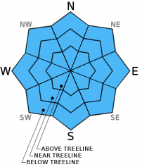
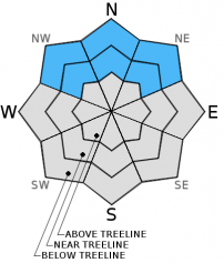
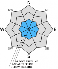
For 7000 ft. to 8000 ft.
Tuesday Tuesday Night Wednesday
Weather: Partly cloudy Partly cloudy becoming mostly cloudy overnight Mostly cloudy
Temperatures: 25 to 32 deg. F. 12 to 18 deg. F. 29 to 34 deg. F.
Mid Slope Winds: Southwest Southwest West
Wind Speed: 15 to 20 mph in the morning becoming light in the afternoon 0 to 5 mph increasing to 10 to 15 mph after midnight 15 to 20 mph with gusts to 30 mph in the afternoon
Expected snowfall: 0 0 0
For 8000 ft. to 9000 ft.
Tuesday Tuesday Night Wednesday
Weather: Partly cloudy Partly cloudy becoming mostly cloudy overnight Mostly cloudy
Temperatures: 18 to 25 deg. F. 5 to 15 deg. F. 21 to 28 deg. F.
Ridge Top Winds: West West West
Wind Speed: 25 to 30 mph with gusts to 40 mph decreasing to 15 to 20 mph with gusts to 30 mph in the afternoon 10 to 15 mph with gusts to 25 mph 10 to 15 mph with gusts to 25 mph increasing to 25 to 30 mph with gusts to 45 mph in the afternoon
Expected snowfall: 0 0 0
Disclaimer

This avalanche advisory is provided through a partnership between the Tahoe National Forest and the Sierra Avalanche Center. This advisory covers the Central Sierra Nevada Mountains between Yuba Pass on the north and Ebbetts Pass on the south. Click here for a map of the forecast area. This advisory applies only to backcountry areas outside established ski area boundaries. This advisory describes general avalanche conditions and local variations always occur. This advisory expires 24 hours after the posted time unless otherwise noted. The information in this advisory is provided by the USDA Forest Service who is solely responsible for its content.