


For 7000 ft. to 8000 ft.
| Friday | Friday Night | Saturday | |
|---|---|---|---|
| Weather: | Cloudy skies with scattered snow showers in the morning. Snow likely in the afternoon. | Cloudy skies with snow. | Cloudy skies with snow. A mix of rain and snow possible. |
| Temperatures: | 26 to 32 deg. F. | 22 to 27 deg. F. | 33 to 40 deg. F. |
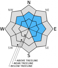
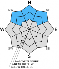
| Mid Slope Winds: | Southwest | Southwest | Southwest |
| Wind Speed: | 20 to 30 mph with gusts to 50 mph | 25 to 35 mph with gusts to 65 mph. | 45 to 55 mph with gusts to 80 mph. |
| Expected snowfall: | 1 to 4 | 6 to 10 | 4 to 8 |
For 8000 ft. to 9000 ft.
| Friday | Friday Night | Saturday | |
|---|---|---|---|
| Weather: | Cloudy skies with scattered snow showers in the morning. Snow likely in the afternoon. | Cloudy skies with snow. | Cloudy skies with snow. |
| Temperatures: | 20 to 26 deg. F. | 18 to 25 deg. F. | 21 to 28 deg. F. |
| Ridge Top Winds: | Southwest | Southwest | Southwest |
| Wind Speed: | 50 to 60 mph with gusts to 90 mph. | 65 to 75 mph with gusts to 110 mph. | 65 to 75 mph with gusts to 105 mph. |
| Expected snowfall: | 2 to 4 | 6 to 12 | 4 to 8 |


