THIS AVALANCHE FORECAST EXPIRED ON February 12, 2014 @ 7:00 am
Avalanche Forecast published on February 11, 2014 @ 7:00 am
Issued by Andy Anderson - Tahoe National Forest - Sierra Avalanche Center

MODERATE avalanche danger exists on slopes 35 degrees and steeper on all aspects in near and above treeline terrain due to wind slabs, the formation of loose wet snow, and unlikely but not impossible deep persistent slabs. MODERATE avalanche danger also exists below treeline on slopes 35 degrees and steeper on the SE-S-SW-W aspects due to the formation of loose wet snow. Although they are becoming more difficult to trigger, large, deep, and destructive avalanches could still occur today.

2. Moderate

?

Above Treeline
Heightened avalanche conditions on specific terrain features. Evaluate snow and terrain carefully; identify features of concern.

2. Moderate

?

Near Treeline
Heightened avalanche conditions on specific terrain features. Evaluate snow and terrain carefully; identify features of concern.

2. Moderate

?

Below Treeline
Heightened avalanche conditions on specific terrain features. Evaluate snow and terrain carefully; identify features of concern.
    Heightened avalanche conditions on specific terrain features. Evaluate snow and terrain carefully; identify features of concern.
Avalanche Problem 1: Wind Slab
  • Type ?
  • Aspect/Elevation ?
  • Likelihood ?
    Certain
    Very Likely
    Likely
    Possible
    Unlikely
  • Size ?
    Historic
    Very Large
    Large
    Small

Large wind slabs still exist on the wind loaded NW-N-NE-E-SE aspects in near and above treeline terrain. Observations have shown these wind slabs at 3-6+ ft in depth. Even though these slabs have become more difficult to trigger due to settlement and consolidation in the storm snow, human triggered wind slabs remain possible. The most fragile wind slabs would remain in complex or extreme terrain; however, the right trigger in the right place could still trigger a wind slab on other wind loaded slopes as well. Large destructive avalanches would result from the failure of these wind slabs.

Avalanche Problem 2: Loose Wet
  • Type ?
  • Aspect/Elevation ?
  • Likelihood ?
    Certain
    Very Likely
    Likely
    Possible
    Unlikely
  • Size ?
    Historic
    Very Large
    Large
    Small

Daytime warming and sunshine on the new snow could cause some wet snow instabilities to form again today. These should remain limited to surface instabilities like roller balls, pin wheels, and wet loose avalanches. Wet slabs should remain unlikely today, but it is not impossible that the sun hitting new snow could cause some slabs to release especially on the wind loaded SE aspects where wind slabs may already exist.

Avalanche Problem 3: Deep Slab
  • Type ?
  • Aspect/Elevation ?
  • Likelihood ?
    Certain
    Very Likely
    Likely
    Possible
    Unlikely
  • Size ?
    Historic
    Very Large
    Large
    Small

In areas above 9,500' deep persistent slabs linger near treeline and below treeline on NW-N-NE aspects. Weak layers of well developed facets and depth hoar remain buried deep in the snowpack in these areas. The strong thick layer of new snow above these weak layers has made triggering them difficult and this kind of avalanche activity has become unlikely. However, it is not impossible for the right trigger in the right place to still release one of these slabs. Areas where a shallower snowpack exists or where trigger points like rocks are closer to the surface could allow humans to still trigger these slides. Locations that are both above 9,500' and near treeline or below treeline terrain represent only a small portion of the forecast area, keeping this problem isolated in distribution.

recent observations

Yesterday on Jakes Peak, data indicated that the new snow has started to quickly settle and consolidate. Some lighter storm snow layers still remain buried under heavier layers, but snowpit tests, ski cuts on steep test slopes, and other general observations did not reveal any signs of instability associated with these layers in this area. Near the summit of Jakes where some larger wind slabs typically form, several large rocks remained exposed and only small wind slabs existed. Again ski cuts did not cause failures in these smaller wind slabs.

On the E-SE-S aspects up to 9160 ft and on all aspects below 7600 ft. some wet snow instabilities existed. At the upper elevations on the SE-S aspects some small roller ball activity occurred on steep slopes near exposed rocks. At the lower elevations a wet saturated snowpack existed and skier triggered roller balls and pinwheels occurred on all aspects.

Due to some cloud cover, the views into the Desolation Wilderness remained partially obscured, but glimpses of Dicks Peak did reveal what looked like some large avalanche crowns. Another observer also reported seeing a large crown on Jacks Peak. These slides likely occurred during the storm.

Weather and CURRENT CONDITIONS
weather summary

A small high pressure ridge over the region should keep temperatures and winds mild today. The winds and cloud cover should begin to increase overnight as a low pressure system moves into far northern CA. By tomorrow wind speeds over the Sierra Crest could climb to 55 to 75 mph with gusts as high as 100 mph. Since this system should carry more warm air with it, temperatures should also stay in the upper 30's to low 40's above 7000 ft tomorrow. The bulk of this system should stay mostly north of the Tahoe area, but some showers could develop over the northern part of the forecast area by Thursday afternoon.  

CONDITIONS ALONG THE SIERRA CREST BETWEEN 8200 FT. AND 9200 FT. IN THE LAST 24 HOURS
6am temperature: 20 to 25 deg. F.
Max. temperature: 35 to 40 deg. F.
Average ridgetop wind direction: Southwest
Average ridgetop wind speed: 10 mph
Maximum ridgetop wind gust: 30 mph
New snowfall: less than 1 inches
Total snow depth: 46 to 58 inches
Two-Day Mountain Weather Forecast Produced in partnership with the Reno NWS
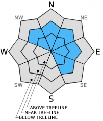
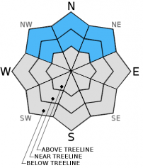
For 7000 ft. to 8000 ft.
Tuesday Tuesday Night Wednesday
Weather: Mostly cloudy to partly sunny Mostly cloudy Cloudy
Temperatures: 37 to 44 deg. F. 23 to 30 deg. F. 40 to 48 deg. F.
Mid Slope Winds: Southwest Southwest Southwest
Wind Speed: 10 to 15 mph with gusts to 25 mph 15 to 20 mph with gusts to 40 mph 15 to 30 mph with gusts to 50 mph
Expected snowfall: 0 0 0
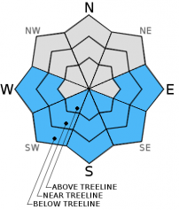
For 8000 ft. to 9000 ft.
Tuesday Tuesday Night Wednesday
Weather: Mostly cloudy to partly sunny Mostly cloudy Cloudy
Temperatures: 32 to 40 deg. F. 24 to 29 deg. F. 34 to 42 deg. F.
Ridge Top Winds: Southwest West West
Wind Speed: 15 to 25 mph with gusts to 35 mph 30 to 45 mph with gusts to 65 mph 55 to 75 mph with gusts at 80 to 100 mph
Expected snowfall: 0 0 0
Disclaimer

This avalanche advisory is provided through a partnership between the Tahoe National Forest and the Sierra Avalanche Center. This advisory covers the Central Sierra Nevada Mountains between Yuba Pass on the north and Ebbetts Pass on the south. Click here for a map of the forecast area. This advisory applies only to backcountry areas outside established ski area boundaries. This advisory describes general avalanche conditions and local variations always occur. This advisory expires 24 hours after the posted time unless otherwise noted. The information in this advisory is provided by the USDA Forest Service who is solely responsible for its content.