THIS AVALANCHE FORECAST EXPIRED ON February 15, 2014 @ 6:55 am
Avalanche Forecast published on February 14, 2014 @ 6:55 am
Issued by Brandon Schwartz - Tahoe National Forest

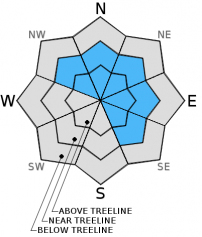
Pockets of MODERATE avalanche danger may exist near and above treeline on NW-N-NE-E-SE aspects due to lingering unstable wind slabs on slopes 35 degrees and steeper. In wind protected areas below treeline and in wind scoured areas near and above treeline, avalanche danger is LOW.

2. Moderate

?

Above Treeline
Heightened avalanche conditions on specific terrain features. Evaluate snow and terrain carefully; identify features of concern.

2. Moderate

?

Near Treeline
Heightened avalanche conditions on specific terrain features. Evaluate snow and terrain carefully; identify features of concern.

1. Low

?

Below Treeline
Generally safe avalanche conditions. Watch for unstable snow on isolated terrain features.
    Heightened avalanche conditions on specific terrain features. Evaluate snow and terrain carefully; identify features of concern.
Avalanche Problem 1: Wind Slab
  • Type ?
  • Aspect/Elevation ?
  • Likelihood ?
    Certain
    Very Likely
    Likely
    Possible
    Unlikely
  • Size ?
    Historic
    Very Large
    Large
    Small

Strong to gale force ridgetop winds over the past 48 hours redistributed snow on the ground following the last weekend's storm cycle. Windward areas are becoming scoured and little to no snow remains available for continued wind transport despite ongoing gale force ridgetop winds. Previous wind loading and subsequent wind slab formation has been observed near and above treeline on NW-N-NE-E-SE aspects. Areas above 8,400' that did not receive any rain on Feb 9 had significantly more snow available for wind transport. Pockets of unstable wind slabs 8 inches to 3 feet deep may be encountered today with human triggered avalanches remaining possible.

recent observations

The northern portion of the forecast area received a significant mist and light/moderate rain event yesterday up to at least 10,000'. At the same time, the southern half of the forecast area experience mostly cloudy to sunny skies with increasing amounts of sunshine towards Ebbetts Pass.

Observations made yesterday on Tamarack Peak (Mount Rose Backcountry) noted wet surface snow with the top 1.5 inches wet at 8,600' and 0.5 inches of wet surface snow above 9,000'. Wind slabs at treeline were dense and provided no obvious signs of instability in response to slope cuts. Snowpit data collected below treeline to examine basal facets revealed rounding of large grain facets and old depth hoar in the lower 16 inches of the snowpack on a NE aspect at 9,400'. Snowpit tests indicated that triggering collapse of this weak layer is very difficult and that once collapsed, significant propagation is unlikely. Similar wet snow surface conditions were noted on Andesite Peak (Donner Summit area) with moderate rain at times and wet surface snow 2 to 3 inches deep.

Observations made yesterday on Stevens Peak (Carson Pass area) revealed similar increasing strength of basal facets. Wet surface snow was limited to the top 2 to 3 inches of the snowpack and created by daytime warming rather than by rain/mist. A significant low density weak layer of recent storm snow was noted below recently formed wind slabs in the area.

Weather and CURRENT CONDITIONS
weather summary

Yesterday's weather system is clearing the area, but with another system on its heels for late tomorrow, strong to gale force winds continue. Air temperatures are above average and have remained above freezing for the past 24 hours. Strong to gale force southwest winds will continue today, tonight, and tomorrow. Cloud cover is forecast to thin by this afternoon, leading to partly cloudy skies. Maximum daytime air temperatures are expected to reach the low 40s to low 50s today for areas above 7,000'. A decent chance of precipitation returns to the forecast area tomorrow night.

CONDITIONS ALONG THE SIERRA CREST BETWEEN 8200 FT. AND 9200 FT. IN THE LAST 24 HOURS
6am temperature: 32 to 41 deg. F.
Max. temperature: 35 to 45 deg. F.
Average ridgetop wind direction: Southwest
Average ridgetop wind speed: 55 mph
Maximum ridgetop wind gust: 91 mph
New snowfall: 0 inches
Total snow depth: 44 to 55 inches
Two-Day Mountain Weather Forecast Produced in partnership with the Reno NWS
For 7000 ft. to 8000 ft.
Friday Friday Night Saturday
Weather: Partly cloudy skies. Mostly cloudy skies. Mostly cloudy skies with a slight chance of rain late in the day.
Temperatures: 47 to 52 deg. F. 33 to 38 deg. F. Falling temps during the day, 45 to 50 deg. F.
Mid Slope Winds: Southwest Southwest Southwest
Wind Speed: 20 to 30 mph with gusts to 45 mph. 25 to 35 mph with gusts to 55 mph. 30 to 35 mph with gusts to 55 mph, increasing to 40 to 55 mph with gusts 60 to 80 mph in the afternoon.
Expected snowfall: 0 0 0
For 8000 ft. to 9000 ft.
Friday Friday Night Saturday
Weather: Partly cloudy skies. Mostly cloudy skies. Mostly cloudy skies with a slight chance of snow late in the day.
Temperatures: 40 to 47 deg. F. 31 to 36 deg. F. Falling temps during the day, 38 to 45 deg. F.
Ridge Top Winds: Southwest Southwest Southwest
Wind Speed: 45 to 55 mph with gusts to 95 mph, decreasing to 40 to 50 mph with gusts to 85 mph in the afternoon. 40 to 55 mph with gusts to 80 mph. 55 to 60 mph with gusts to 95 mph, increasing to 65 to 70 mph with gusts to 105 mph.
Expected snowfall: 0 0 0 to trace
Disclaimer

This avalanche advisory is provided through a partnership between the Tahoe National Forest and the Sierra Avalanche Center. This advisory covers the Central Sierra Nevada Mountains between Yuba Pass on the north and Ebbetts Pass on the south. Click here for a map of the forecast area. This advisory applies only to backcountry areas outside established ski area boundaries. This advisory describes general avalanche conditions and local variations always occur. This advisory expires 24 hours after the posted time unless otherwise noted. The information in this advisory is provided by the USDA Forest Service who is solely responsible for its content.