THIS AVALANCHE FORECAST EXPIRED ON February 24, 2014 @ 6:53 am
Avalanche Forecast published on February 23, 2014 @ 6:53 am
Issued by Andy Anderson - Tahoe National Forest - Sierra Avalanche Center

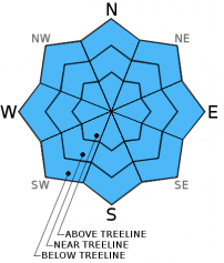
The avalanche danger remains LOW at all elevations and on all aspects. Continue to use normal caution when traveling in the backcountry.

1. Low

?

Above Treeline
Generally safe avalanche conditions. Watch for unstable snow on isolated terrain features.

1. Low

?

Near Treeline
Generally safe avalanche conditions. Watch for unstable snow on isolated terrain features.

1. Low

?

Below Treeline
Generally safe avalanche conditions. Watch for unstable snow on isolated terrain features.
    Generally safe avalanche conditions. Watch for unstable snow on isolated terrain features.
Avalanche Problem 1: Normal Caution
  • Type ?
  • Aspect/Elevation ?
  • Likelihood ?
    Certain
    Very Likely
    Likely
    Possible
    Unlikely
  • Size ?
    Historic
    Very Large
    Large
    Small

Even though human triggered avalanches are unlikely today, continue to exercise caution and use best-practice backcountry travel techniques including avoiding terrain traps that magnify the consequences of small avalanches and only putting one person on a slope at a time. Some small areas of unstable snow could still lurk on isolated terrain features during LOW danger days. Complex or extreme terrain like unsupported slopes above cliff bands, couliors, etc represent the places where these unlikely but not impossible patches unstable snow could linger in the form of small wind slabs. On the most sun-exposed SE-S-SW aspects a few small isolated wet snow instabilities could also form today.

recent observations

Observations yesterday on Mt. Judah and near Relay Peak continued to indicate a stable and well-consolidated snowpack. Some hard wind slabs did exist in on N-NE-E aspects in both areas but the vast majority of observations indicated that these slabs have bonded to the snow/crusts below them and that breaking them loose has become unlikely. The northerly aspects and areas shaded from the sun held a wide variety of surface conditions ranging from a few inches of soft snow on sheltered slopes to wind packed snow to wind scoured surfaces to hard frozen crusts at lower elevations.

On the more sun exposed SE-S-SW aspects, 1-2 inches of soft melt-freeze snow formed up to 8200 ft. on Mt. Judah by noon. At the higher elevations on Relay Peak less melting meant that less soft surface snow formed and that it remained limited to the sunniest southerly aspects. Observations did not reveal any wet snow instabilities in either location yesterday.

Weather and CURRENT CONDITIONS
weather summary

The high pressure ridge over the region will allow the mild spring-like weather to continue through Tuesday. The forecast calls for clear skies and daytime highs in the mid to upper 40's above 7000 ft. today and tomorrow. The southwest winds should also remain light through tomorrow. The calm weather has also allowed cold air to settle into the valleys this morning and temperatures at the lower elevations are currently colder than those at the higher elevations. As the day warms up, this inversion should lift.

CONDITIONS ALONG THE SIERRA CREST BETWEEN 8200 FT. AND 9200 FT. IN THE LAST 24 HOURS
6am temperature: 24 to 35 deg. F.
Max. temperature: 39 to 49 deg. F.
Average ridgetop wind direction: Southwest
Average ridgetop wind speed: 5 to 15 mph
Maximum ridgetop wind gust: 24 mph
New snowfall: 0 inches
Total snow depth: 37 to 45 inches
Two-Day Mountain Weather Forecast Produced in partnership with the Reno NWS
For 7000 ft. to 8000 ft.
Sunday Sunday Night Monday
Weather: Sunny Clear Sunny with some clouds moving into the area in the afternoon
Temperatures: 42 to 49 deg. F. 24 to 30 deg. F. 43 to 50 deg. F.
Mid Slope Winds: Southwest Variable Variable
Wind Speed: 0 to 5 mph in the morning increasing to 10 to 15 mph in the afternoon Light Light
Expected snowfall: 0 0 0
For 8000 ft. to 9000 ft.
Sunday Sunday Night Monday
Weather: Sunny Clear Sunny with some clouds moving into the area in the afternoon
Temperatures: 42 to 48 deg. F. 25 to 31 deg. F. 43 to 49 deg. F.
Ridge Top Winds: Southwest Southwest Southwest
Wind Speed: 10 to 15 mph with gusts to 25 mph in the afternoon 10 to 15 mph with gusts to 25 mph 10 to 15 mph in the morning becoming light in the afternoon
Expected snowfall: 0 0 0
Disclaimer

This avalanche advisory is provided through a partnership between the Tahoe National Forest and the Sierra Avalanche Center. This advisory covers the Central Sierra Nevada Mountains between Yuba Pass on the north and Ebbetts Pass on the south. Click here for a map of the forecast area. This advisory applies only to backcountry areas outside established ski area boundaries. This advisory describes general avalanche conditions and local variations always occur. This advisory expires 24 hours after the posted time unless otherwise noted. The information in this advisory is provided by the USDA Forest Service who is solely responsible for its content.