THIS AVALANCHE FORECAST EXPIRED ON March 1, 2014 @ 7:00 am
Avalanche Forecast published on February 28, 2014 @ 7:00 am
Issued by Andy Anderson - Tahoe National Forest - Sierra Avalanche Center

CONSIDERABLE danger exists on slopes 35 degrees and steeper at all elevations on NW-N-NE aspects and on near and above treeline, wind loaded, W, E, and SE aspects. MODERATE avalanche danger exists in all other areas. Human triggered wind slab and storm slab avalanches are likely today.

3. Considerable

?

Above Treeline
Dangerous avalanche conditions. Careful snowpack evaluation, cautious route-finding and conservative decision-making essential.

3. Considerable

?

Near Treeline
Dangerous avalanche conditions. Careful snowpack evaluation, cautious route-finding and conservative decision-making essential.

3. Considerable

?

Below Treeline
Dangerous avalanche conditions. Careful snowpack evaluation, cautious route-finding and conservative decision-making essential.
    Dangerous avalanche conditions. Careful snowpack evaluation, cautious route-finding and conservative decision-making essential.
Avalanche Problem 1: Wind Slab
  • Type ?
  • Aspect/Elevation ?
  • Likelihood ?
    Certain
    Very Likely
    Likely
    Possible
    Unlikely
  • Size ?
    Historic
    Very Large
    Large
    Small

Natural wind slab avalanches will become possible today and human triggered wind slab avalanches will be likely. More strong winds and additional snowfall today will cause the fragile wind slabs that already exist on leeward aspects to increase in size and extent. Wind slabs 2-5 ft in depth could exist on wind loaded slopes by the end of the day. These wind slabs rest on top of a mix of old crusts, layers of weak sugary snow, and layers of lighter storm snow. These wind slab avalanches could fail at or above the old/new snow interface. Due to the shifting south and southwest winds the wind slabs could exist on W-NW-N-NE-E-SE aspects in near and above treeline terrain.

Avalanche Problem 2: Storm Slab
  • Type ?
  • Aspect/Elevation ?
  • Likelihood ?
    Certain
    Very Likely
    Likely
    Possible
    Unlikely
  • Size ?
    Historic
    Very Large
    Large
    Small

Changing temperatures, winds, and snowfall rates will cause a variety of layers to form within the new snow. Some of these layers will represent small slab layers and some will represent weak layers. As a result of this stratigraphy unstable storm slabs could exist on all aspects in near and below treeline terrain. The most fragile storm slabs will lurk on the below treeline north and northeast aspects where thin layers of soft sugary snow exist near the old/new snow interface. Snowpack failure is expected to occur just below, at, or above the old/new snow interface with slab thickness expected at around 1 to 2 ft. Human triggered avalanches will be likely below treeline today on the northerly aspects and possible on all other aspects.

recent observations

Yesterday, ski cuts on a below treeline steep NE facing slope near Grouse Rocks resulted in a small (6-8 inch crown, 75 ft. wide) storm slab avalanche that ran down hill for 150 ft. This slide failed on the layer of weak sugary snow at the base of the storm snow. On Tamarack Peak stomping on a ridgeline triggered a wind slab avalanche 300 ft. away in steeper wind loaded terrain. This avalanche had a 2-3 ft crown and measured about 300 ft. wide. It ran down to the bottom of a 350 ft. slope where the debris piled up. This wind slab avalanche failed on a slightly less dense layer of storm snow at the base of the new snow on top of a firm melt freeze crust.

Farther south on Powderhouse Peak, some data indicated that the new snow had bonded well to the old snow surfaces, while other data indicated weak and fragile bonding. Some tests indicated that fractures could easily travel along this interface and other tests indicated that they should not. Ski cuts on test slopes in this area did not produce any results.

In all three areas, strong winds continued to move snow and wind load leeward slopes yesterday.

Weather and CURRENT CONDITIONS
weather summary

As yesterday's storm tapered off, the winds decreased and shifted to the south overnight and temperatures increased. The lingering snow showers did produce another 2-3 inches of snow above 7000 ft. in the last 24 hours. A second storm started to impact the the forecast area this morning with increased south winds and more snow. The forecast calls for another 6 to 9 inches of snow in the mountains above 7000 ft today and 2 to 4 inches tonight. By tomorrow snow showers should start to taper off. Overall the mountains above 7000 ft could see an additional 9-16 inches of new snow in the next 36 hours. The southern half of the forecast area could see even more snow with 12 to 18 inches possible along the Sierra Crest south of Hwy 50. Winds shifting between south and southwest at 30 to 45 mph with gusts as high as 70 mph today should accompany this storm. Temperatures should steadily fall over the next 24 hours during this storm.

CONDITIONS ALONG THE SIERRA CREST BETWEEN 8200 FT. AND 9200 FT. IN THE LAST 24 HOURS
6am temperature: 22 to 32 deg. F.
Max. temperature: 24 to 35 deg. F.
Average ridgetop wind direction: Southwest shifting to the south
Average ridgetop wind speed: Before 6pm yesterday: 30 to 40 mph | After 6pm: 10 to 20 mph
Maximum ridgetop wind gust: 56 mph
New snowfall: 2 inches
Total snow depth: 46 to 50 inches
Two-Day Mountain Weather Forecast Produced in partnership with the Reno NWS
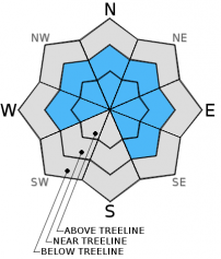
For 7000 ft. to 8000 ft.
Friday Friday Night Saturday
Weather: Snow Snow Cloudy with snow showers likely
Temperatures: 28 to 32 deg. F. 20 to 24 deg. F. 28 to 34 deg. F.
Mid Slope Winds: South Southwest South
Wind Speed: 20 to 30 mph with gusts to 45 mph 15 to 25 mph with gusts to 35 mph 15 to 20 mph with gusts to 40 mph decreasing to 30 mph in the afternoon
Expected snowfall: 6 to 8 2 to 4 .5 to 2
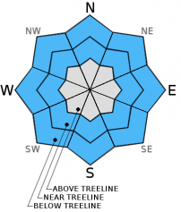
For 8000 ft. to 9000 ft.
Friday Friday Night Saturday
Weather: Snow Snow Cloudy with snow showers likely
Temperatures: 25 to 28 deg. F. 18 to 24 deg. F. 26 to 30 deg. F.
Ridge Top Winds: South Southwest Southwest shifting to the south in the afternoon
Wind Speed: 35 to 45 mph with gusts to 70 mph 25 to 35 mph with gusts to 55 mph 35 to 40 mph with gusts to 60 mph
Expected snowfall: 6 to 9 2 to 4 1 to 3
Disclaimer

This avalanche advisory is provided through a partnership between the Tahoe National Forest and the Sierra Avalanche Center. This advisory covers the Central Sierra Nevada Mountains between Yuba Pass on the north and Ebbetts Pass on the south. Click here for a map of the forecast area. This advisory applies only to backcountry areas outside established ski area boundaries. This advisory describes general avalanche conditions and local variations always occur. This advisory expires 24 hours after the posted time unless otherwise noted. The information in this advisory is provided by the USDA Forest Service who is solely responsible for its content.