


For 7000 ft. to 8000 ft.
| Monday | Monday Night | Tuesday | |
|---|---|---|---|
| Weather: | Mostly cloudy skies becoming cloudy. Scattered rain/snow showers in the morning. Isolated rain/snow showers in the afternoon. | Cloudy skies with scattered showers in the evening. Rain and snow likely after midnight. | Mostly cloudy skies, becoming partly cloudy. |
| Temperatures: | 36 to 43 deg. F. | 24 to 31 deg. F. | 40 to 47 deg. F. |
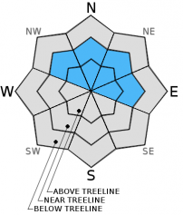
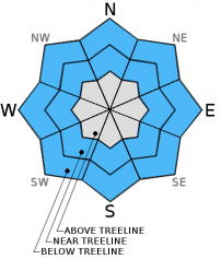
| Mid Slope Winds: | Southwest | Southwest | West |
| Wind Speed: | 15 to 25 mph with gusts to 40 mph. | 15 to 20 mph with gusts to 30 mph. | Light winds |
| Expected snowfall: | Up to 1 | 2 to 4 | 0 |
For 8000 ft. to 9000 ft.
| Monday | Monday Night | Tuesday | |
|---|---|---|---|
| Weather: | Mostly cloudy skies becoming cloudy. Scattered snow showers in the morning. Isolated snow showers in the afternoon. | Cloudy skies with scattered snow showers in the evening. Snow after midnight. | Mostly cloudy skies, becoming partly cloudy. |
| Temperatures: | 35 to 41 deg. F. | 20 to 27 deg. F. | 40 to 46 deg. F. |
| Ridge Top Winds: | Southwest | Southwest | West |
| Wind Speed: | 30 to 40 mph with gusts to 60 mph. | 20 to 30 mph with gusts to 45 mph. Gusts decreasing to 35 mph after midnight. | 10 to 15 mph. Gusts to 25 mph in the morning. |
| Expected snowfall: | Up to 1 | 2 to 4 | 0 |


